Category:Clinique Sainte-Marthe (Angoulême)
Jump to navigation
Jump to search
| Object location | | View all coordinates using: OpenStreetMap |
|---|
|
This building is inscrit au titre des monuments historiques de la France. It is indexed in the base Mérimée, a database of architectural heritage maintained by the French Ministry of Culture, under the reference PA00104205
|
hospital  | |||||
| Upload media | |||||
| Instance of | |||||
|---|---|---|---|---|---|
| Location | Angoulême, canton of Angoulême-Nord | ||||
| Street address |
| ||||
| Heritage designation |
| ||||
 | |||||
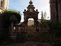
English: Old 17th century water well and gate, former clinic Sainte-Marthe, rue du Minage, Vieil Angoulême, Charente, SW France
Français : Ancienne clinique Sainte-Marthe, 5-11 rue du Minage, Angoulême (Charente, France). Puits et porte XVIIe siècle.
Media in category "Clinique Sainte-Marthe (Angoulême)"
The following 5 files are in this category, out of 5 total.
-
 AngSteMarthe3.JPG 3,024 × 4,032; 2.57 MB
-
 AngSteMarthe5.JPG 4,032 × 3,024; 2.45 MB
-
 AngSteMarthe6.JPG 4,032 × 3,024; 2.39 MB
-
 AngSteMarthe7.JPG 4,032 × 3,024; 2.35 MB
-


