Category:Co-op, Eaton Road
Jump to navigation
Jump to search
| Object location | | View all coordinates using: OpenStreetMap |
|---|
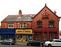
Former branch of the Co-op, Eaton Road, West Derby.
Media in category "Co-op, Eaton Road"
The following 2 files are in this category, out of 2 total.
-
 Co-op, Eaton Road 1.jpg 4,581 × 3,560; 6.34 MB
-
 Co-op, Eaton Road 2.jpg 4,864 × 3,518; 7.75 MB

