Category:Complete Atlas of China (1917)
Jump to navigation
Jump to search
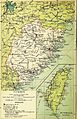
_p12_Index_map_(14783818285).jpg)
English: The Complete Atlas of China: Containing Separate Maps of the Eighteen Provinces of China Proper on the Scale of 1:3,000,000 and of the Four Great Dependencies on the Scale of 1:7,500,000 together with an Index to All the Names on the Maps with the Latitude and Longitude of Each Place: All Railways, Telegraph Stations, Ports, & Protestant Mission Stations Marked was an atlas of the Qing Empire (1st ed., 1908) or Republic of China (2nd ed., 1917) completed by Edward Stanford for the China Inland Mission, using the Postal Map romanization of Chinese names.
The 18 Provinces of China Proper:
- 1. KWANGTUNG (i.e., Guangdong & Hainan)
- 2. FUKIEN (Fujian)
- 3. CHEKIANG (Zhejiang)
- 4. KIANGSU (Jiangsu & Shanghai)
- 5. SHANTUNG (Shandong)
- 6. CHIHLI (Zhili, now Hebei, Beijing, & Tianjin)
- 7. HUPEH (Hubei)
- 8. KIANGSI (Jiangxi)
- 9. HONAN (Henan)
- 10. ANHWEI (Anhui)
- 11. HUNAN
- 12. KANSU (Gansu)
- 13. SHENSI (Shaanxi)
- 14. SHANSI (Shanxi)
- 15. SZECHWAN (Sichuan & Chongqing)
- 16. YUNNAN
- 17. KWEICHOW (Guizhou)
- 18. KWANGSI (Guangxi)
The Four Great Dependencies:
- 19. SINKIANG (Xinjiang)
- 20. MANCHURIA (now Northeast China: Heilongjiang, Jilin, & Liaoning)
- 21. TIBET (Tibet & Qinghai)
- 22. MONGOLIA (now the country of Mongolia and the Chinese autonomous region of Inner Mongolia)
Media in category "Complete Atlas of China (1917)"
The following 49 files are in this category, out of 49 total.
-
 STANFORD(1917) Complete atlas of China.jpg 2,575 × 3,971; 2.35 MB
-
 STANFORD(1917) p04 Info.jpg 2,575 × 3,971; 1.26 MB
-
 STANFORD(1917) p05 Title.jpg 2,575 × 3,971; 1.87 MB
-
 STANFORD(1917) p11 Content.jpg 2,575 × 3,971; 480 KB
-

-
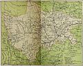
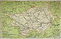
 Map of Tibet in 1917, STANFORD(1917) p12 Index map (14783818285) (cropped).jpg 1,322 × 812; 101 KB
-
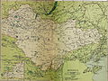
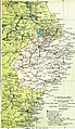
 STANFORD(1917) p12 Index map (14783818285).jpg 3,456 × 2,228; 920 KB
-
 STANFORD(1917) p15-16 PLATE 1. KWANGTUNG (14597113490).jpg 4,790 × 3,795; 8.54 MB
-

-
 STANFORD(1917) p19 PLATE 2. FUKIEN (14803676033).jpg 2,336 × 3,612; 2 MB
-
 STANFORD(1917) p21 PLATE 3. CHEKIANG.jpg 2,575 × 3,971; 6.99 MB
-
 STANFORD(1917) p24 PLATE 4. KIANGSU.jpg 2,575 × 3,971; 7.14 MB
-
 STANFORD(1917) p24 PLATE 5. SHANTUNG (14597119880).jpg 3,776 × 2,448; 2.14 MB
-
 STANFORD(1917) p27-28 PLATE 6. CHIHLI (14597121010).jpg 4,777 × 3,878; 9.76 MB
-
 STANFORD(1917) p31 PLATE 7. HUPEH (14780683651).jpg 3,712 × 2,370; 1.87 MB
-
 STANFORD(1917) p32 PLATE 8. KIANGSI (14783482962).jpg 2,450 × 3,794; 1.99 MB
-
 STANFORD(1917) p35 PLATE 9. HONAN (14597124160).jpg 2,342 × 3,718; 2.05 MB
-
 STANFORD(1917) p36 PLATE10. ANHWEI (14597315587).jpg 2,410 × 3,820; 2.05 MB
-
 STANFORD(1917) p38 PLATE11. HUNAN (14780687161).jpg 2,408 × 3,796; 1.9 MB
-
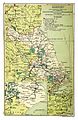
 Map of Tibet in 1917, from- STANFORD(1917) p41-42 PLATE12. KANSU (14780689431) (cropped).jpg 2,633 × 3,139; 2.84 MB
-
 STANFORD(1917) p41-42 PLATE12. KANSU (14780689431).jpg 4,923 × 4,507; 7.5 MB
-
 STANFORD(1917) p45 PLATE13. SHENSI (14780690291).jpg 2,422 × 3,816; 1.74 MB
-
 STANFORD(1917) p46 PLATE14. SHANSI (14597130080).jpg 2,420 × 3,866; 1.98 MB
-
 STANFORD(1917) p49-50 PLATE15. SZECHWAN (14783836675).jpg 4,831 × 3,809; 14.65 MB
-
 STANFORD(1917) p53-54 PLATE16. YUNNAN (14597193058).jpg 4,733 × 3,822; 9.85 MB
-
 STANFORD(1917) p57 PLATE17. KWEICHOW (14597174929).jpg 3,744 × 2,370; 1.99 MB
-
 STANFORD(1917) p58 PLATE18. KWANGSI (14760844646).jpg 3,808 × 2,420; 2.09 MB
-
 STANFORD(1917) p61 PLATE19. SINKIANG (14597194848).jpg 3,712 × 2,302; 1.51 MB
-
 STANFORD(1917) p63 PLATE20. MANCHURIA.jpg 2,575 × 3,971; 6.5 MB
-
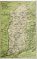
 STANFORD(1917) p64 PLATE21. TIBET (14803693893).jpg 3,744 × 2,438; 1.59 MB
-
 STANFORD(1917) p67-68 PLATE22. MONGOLIA (14597137480).jpg 4,783 × 3,600; 8.46 MB
-
 STANFORD(1917) p71 Index.jpg 1,288 × 1,986; 1.76 MB
-
 STANFORD(1917) p72 Index.jpg 1,288 × 1,986; 2.13 MB
-
 STANFORD(1917) p73 Index.jpg 1,288 × 1,986; 2.08 MB
-
 STANFORD(1917) p74 Index.jpg 1,288 × 1,986; 2.04 MB
-
 STANFORD(1917) p75 Index.jpg 1,288 × 1,986; 2.08 MB
-
 STANFORD(1917) p76 Index.jpg 1,288 × 1,986; 2.08 MB
-
 STANFORD(1917) p77 Index.jpg 1,288 × 1,986; 2.09 MB
-
 STANFORD(1917) p78 Index.jpg 1,288 × 1,986; 2.08 MB
-
 STANFORD(1917) p79 Index.jpg 1,288 × 1,986; 2.09 MB
-
 STANFORD(1917) p80 Index.jpg 1,288 × 1,986; 2.04 MB
-
 STANFORD(1917) p81 Index.jpg 1,288 × 1,986; 2.1 MB
-
 STANFORD(1917) p82 Index.jpg 1,288 × 1,986; 2.07 MB
-
 STANFORD(1917) p83 Index.jpg 1,288 × 1,986; 2.08 MB
-
 STANFORD(1917) p84 Index.jpg 1,288 × 1,986; 2 MB
-
 STANFORD(1917) p85 Index.jpg 2,575 × 3,971; 6.33 MB
-
-
-
 Zaidam Swamp.png 787 × 384; 583 KB
_Complete_atlas_of_China.jpg)
_p04_Info.jpg)
_p05_Title.jpg)
_p11_Content.jpg)
_p12_Index_map_(14783818285)_(cropped).jpg)
_p12_Index_map_(14783818285)_(cropped).jpg)
_p15-16_PLATE_1._KWANGTUNG_(14597113490).jpg)
_in_1917_from-_STANFORD_(1917)_p19_PLATE_2._FUKIEN_(14803676033)_(cropped).jpg)
_p19_PLATE_2._FUKIEN_(14803676033).jpg)
_p21_PLATE_3._CHEKIANG.jpg)
_p24_PLATE_4._KIANGSU.jpg)
_p24_PLATE_5._SHANTUNG_(14597119880).jpg)
_p27-28_PLATE_6._CHIHLI_(14597121010).jpg)
_p31_PLATE_7._HUPEH_(14780683651).jpg)
_p32_PLATE_8._KIANGSI_(14783482962).jpg)
_p35_PLATE_9._HONAN_(14597124160).jpg)
_p36_PLATE10._ANHWEI_(14597315587).jpg)
_p38_PLATE11._HUNAN_(14780687161).jpg)
_p41-42_PLATE12._KANSU_(14780689431)_(cropped).jpg)
_p41-42_PLATE12._KANSU_(14780689431).jpg)
_p45_PLATE13._SHENSI_(14780690291).jpg)
_p46_PLATE14._SHANSI_(14597130080).jpg)
_p49-50_PLATE15._SZECHWAN_(14783836675).jpg)
_p53-54_PLATE16._YUNNAN_(14597193058).jpg)
_p57_PLATE17._KWEICHOW_(14597174929).jpg)
_p58_PLATE18._KWANGSI_(14760844646).jpg)
_p61_PLATE19._SINKIANG_(14597194848).jpg)
_p63_PLATE20._MANCHURIA.jpg)
_p64_PLATE21._TIBET_(14803693893).jpg)
_p67-68_PLATE22._MONGOLIA_(14597137480).jpg)
_p71_Index.jpg)
_p72_Index.jpg)
_p73_Index.jpg)
_p74_Index.jpg)
_p75_Index.jpg)
_p76_Index.jpg)
_p77_Index.jpg)
_p78_Index.jpg)
_p79_Index.jpg)
_p80_Index.jpg)
_p81_Index.jpg)
_p82_Index.jpg)
_p83_Index.jpg)
_p84_Index.jpg)
_p85_Index.jpg)
_(14597309577).jpg)
