Category:Cookney
Jump to navigation
Jump to search
English: Cookney is a hamlet in Aberdeenshire, Scotland in proximity to Netherley in the Mounth of the Grampian Highlands. The community is situated on a hilltop approximately five miles northwest of Stonehaven and about three miles northwest of the Bridge of Muchalls. Cookney lies about two miles west of Muchalls Castle. From Cookney a portion of the ancient route of the Causey Mounth is visible to the east near Whinward Farm, although the track is not truly recognizable from that distance of about two miles. The Cookney Church is a prominent historic landmark of Cookney.
village in Aberdeenshire, Scotland, UK  | |||||
| Upload media | |||||
| Instance of | |||||
|---|---|---|---|---|---|
| Location |
| ||||
 | |||||
Media in category "Cookney"
The following 82 files are in this category, out of 82 total.
-
 19th century post box, Cookney - geograph.org.uk - 2978920.jpg 640 × 480; 123 KB
-
 B979 Stonehaven to Peterculter Road - geograph.org.uk - 168614.jpg 640 × 475; 92 KB
-

-
 Cookney Church- R.U.M. House - geograph.org.uk - 2728784.jpg 640 × 480; 73 KB
-
 Cookney Church.jpg 640 × 480; 84 KB
-
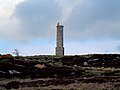
 Cookney War Memorial - geograph.org.uk - 2978925.jpg 640 × 480; 91 KB
-

-
 Northward Farm (ruin) - geograph.org.uk - 494572.jpg 640 × 480; 82 KB
-

-

-

-
 Sign at Entrance to Allochie Lochan - geograph.org.uk - 168638.jpg 640 × 475; 109 KB
-
 The road to Wedderhill - geograph.org.uk - 178551.jpg 640 × 480; 75 KB
-
 Allochie Lochan - geograph.org.uk - 168645.jpg 640 × 475; 75 KB
-
 Approach to Netherley from Burnend - geograph.org.uk - 365582.jpg 640 × 480; 92 KB
-
 Balnagubs - geograph.org.uk - 512531.jpg 640 × 480; 101 KB
-
 Bentyhowe - geograph.org.uk - 541204.jpg 640 × 480; 107 KB
-
 Berrytop - geograph.org.uk - 512519.jpg 640 × 480; 98 KB
-
 Berrytop - geograph.org.uk - 512523.jpg 640 × 480; 105 KB
-
 Boswell's Monument - geograph.org.uk - 178042.jpg 640 × 480; 96 KB
-
 Boswell's Monument Plaque - geograph.org.uk - 178043.jpg 514 × 640; 154 KB
-

-
 Buildings at Newhall - geograph.org.uk - 500849.jpg 640 × 426; 80 KB
-
 Burn of Monboys watershed - geograph.org.uk - 599726.jpg 640 × 173; 17 KB
-
 Burnhead - geograph.org.uk - 365555.jpg 640 × 480; 72 KB
-
 Burnhead Croft - geograph.org.uk - 365575.jpg 640 × 480; 95 KB
-
 Burnside Farm Junction - geograph.org.uk - 500758.jpg 640 × 426; 105 KB
-
 Burnside of Newhall - geograph.org.uk - 539596.jpg 640 × 480; 81 KB
-
 Burnside of Newhall - geograph.org.uk - 539599.jpg 640 × 480; 82 KB
-
 Cairnhill - geograph.org.uk - 500797.jpg 640 × 426; 107 KB
-
 Cairnhill Farm junction - geograph.org.uk - 500820.jpg 640 × 426; 75 KB
-
 Clayfolds - geograph.org.uk - 365491.jpg 640 × 480; 98 KB
-
 Cookney junction at Burnhead - geograph.org.uk - 365560.jpg 640 × 480; 138 KB
-

-
 Drive way to Mains of Altries - geograph.org.uk - 500710.jpg 640 × 480; 138 KB
-
 Eastside farm steading - geograph.org.uk - 500699.jpg 640 × 480; 98 KB
-
 Electricity pylons - geograph.org.uk - 365740.jpg 480 × 640; 51 KB
-
 Elrick - geograph.org.uk - 365513.jpg 640 × 480; 64 KB
-
 Entrance to an old farm - geograph.org.uk - 512508.jpg 640 × 480; 97 KB
-
 Farm buildings by South Cookney - geograph.org.uk - 365551.jpg 640 × 480; 67 KB
-
 Farm Track - geograph.org.uk - 500717.jpg 640 × 426; 80 KB
-

-
 Farm track to Burnside Farm - geograph.org.uk - 500763.jpg 640 × 426; 107 KB
-
 Field at Auchlee Hill - geograph.org.uk - 178050.jpg 640 × 151; 39 KB
-

-
 Floodplain of the Burn of Muchalls - geograph.org.uk - 1425092.jpg 640 × 474; 183 KB
-

-
 Highland cows - geograph.org.uk - 453003.jpg 640 × 480; 104 KB
-
 Lairhillock Inn - geograph.org.uk - 30727.jpg 640 × 480; 124 KB
-
 Looking towards Hawkhill Wood - geograph.org.uk - 30732.jpg 640 × 480; 72 KB
-
 Meikle Carewe - geograph.org.uk - 169594.jpg 640 × 480; 82 KB
-
 Mill of Monquich, Netherley - geograph.org.uk - 30812.jpg 640 × 480; 72 KB
-
 Newhall and Elsick - geograph.org.uk - 539601.jpg 640 × 480; 84 KB
-
 Oldman Wood - geograph.org.uk - 500719.jpg 640 × 480; 90 KB
-
 Parkies brae Maryculter - geograph.org.uk - 607386.jpg 640 × 480; 116 KB
-

-
 Private Fishing pond - geograph.org.uk - 500725.jpg 640 × 426; 89 KB
-
 Private Fishing pond - geograph.org.uk - 500730.jpg 640 × 426; 107 KB
-
 Recumbent stone circle - geograph.org.uk - 178053.jpg 640 × 173; 45 KB
-
 Red Moss - geograph.org.uk - 541218.jpg 640 × 480; 91 KB
-
 Red Moss - geograph.org.uk - 541220.jpg 640 × 480; 95 KB
-
 Residents of NO8896 - geograph.org.uk - 178056.jpg 640 × 480; 84 KB
-
 Road from Auchlee - geograph.org.uk - 178055.jpg 640 × 480; 117 KB
-
 Road junction by Clayfolds - geograph.org.uk - 365504.jpg 640 × 480; 51 KB
-
 Road junction by Eastfield Farm - geograph.org.uk - 365483.jpg 640 × 414; 63 KB
-
 Road junction to the farm at Crossley - geograph.org.uk - 500708.jpg 640 × 391; 79 KB
-
 Road to Bentyhowe - geograph.org.uk - 541197.jpg 480 × 640; 150 KB
-
 Rocklea - geograph.org.uk - 365525.jpg 640 × 480; 57 KB
-
 Rough Track to Nowhere - geograph.org.uk - 168659.jpg 475 × 640; 95 KB
-
 Sheep grazing above Crynoch Burn - geograph.org.uk - 595923.jpg 640 × 443; 61 KB
-
 Small wood - geograph.org.uk - 541208.jpg 640 × 480; 88 KB
-
 South Cookney - geograph.org.uk - 365545.jpg 640 × 480; 103 KB
-
 Springfield, Netherley - geograph.org.uk - 365591.jpg 640 × 480; 117 KB
-
 Stable buildings - geograph.org.uk - 512494.jpg 640 × 480; 90 KB
-
 Standing stone - geograph.org.uk - 500713.jpg 480 × 640; 91 KB
-
 Standing Stones and Ring Cairn - geograph.org.uk - 167968.jpg 640 × 480; 102 KB
-
 Stony Hill - geograph.org.uk - 541215.jpg 640 × 480; 90 KB
-
 Stranog Hill - geograph.org.uk - 500735.jpg 640 × 426; 90 KB
-
 Stranog Hill - geograph.org.uk - 500739.jpg 640 × 480; 75 KB
-
 Stranog Hill reservoir - geograph.org.uk - 500732.jpg 640 × 480; 83 KB
-
 Track from South Cookney - geograph.org.uk - 365538.jpg 640 × 480; 74 KB
-
 Track to Allochie - geograph.org.uk - 168656.jpg 640 × 475; 86 KB


_-_geograph.org.uk_-_494572.jpg)


