Category:Corwen (community)
Jump to navigation
Jump to search
Subcategories
This category has the following 2 subcategories, out of 2 total.
Media in category "Corwen (community)"
The following 200 files are in this category, out of 760 total.
(previous page) (next page)-
 "Postman's Walk" - geograph.org.uk - 2933507.jpg 1,600 × 1,200; 565 KB
-
 'Let me outta of here' - geograph.org.uk - 4128227.jpg 640 × 480; 122 KB
-
 20th Century dream gone sour - geograph.org.uk - 2938828.jpg 1,600 × 1,200; 525 KB
-
 7822 Foxcote Manor (2) - geograph.org.uk - 2181621.jpg 3,296 × 2,472; 1.99 MB
-
 A by-product of grassland improvement - geograph.org.uk - 1657813.jpg 640 × 428; 100 KB
-
 A fork in the lane - geograph.org.uk - 3025784.jpg 640 × 425; 119 KB
-
 A good recently erected sheep fence - geograph.org.uk - 1657797.jpg 640 × 428; 99 KB
-
 A long slow descent - geograph.org.uk - 3545255.jpg 640 × 480; 75 KB
-

-
 A place in the woods - geograph.org.uk - 2914924.jpg 1,600 × 1,200; 688 KB
-
 A quarry man's chimney - geograph.org.uk - 2970893.jpg 1,600 × 1,071; 483 KB
-
 A star returns to steam - geograph.org.uk - 2194984.jpg 640 × 480; 87 KB
-
 A steep track down to Bronwynedd - geograph.org.uk - 3023079.jpg 640 × 425; 101 KB
-
 A sudden steep rise - geograph.org.uk - 2914957.jpg 1,600 × 1,200; 801 KB
-
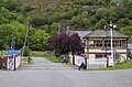
 A T2 TrawsCymru service stands at Corwen - geograph.org.uk - 4926998.jpg 640 × 480; 165 KB
-
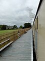
 A train approaching Corwen East station - geograph.org.uk - 4927037.jpg 640 × 480; 191 KB
-

-
 A494 between Druid and Bala - geograph.org.uk - 3393643.jpg 3,475 × 2,729; 1.75 MB
-
 A5 approaching the Bala turning - geograph.org.uk - 3176017.jpg 640 × 430; 69 KB
-
 A5 approaching the River Dee - geograph.org.uk - 3177436.jpg 640 × 383; 66 KB
-
 A5 by a layby - geograph.org.uk - 3126976.jpg 640 × 430; 85 KB
-
 A5 crossing the River Dee - geograph.org.uk - 3563014.jpg 3,216 × 2,136; 3.55 MB
-
 A5 east of Llidiart-y-Parc - geograph.org.uk - 3181307.jpg 640 × 430; 88 KB
-
 A5 entering Corwen - geograph.org.uk - 3177448.jpg 640 × 430; 90 KB
-
 A5 entering Llidiart-y-Parc - geograph.org.uk - 3181304.jpg 640 × 430; 92 KB
-
 A5 follows the Llangollen Railway - geograph.org.uk - 5230913.jpg 4,608 × 3,456; 6.52 MB
-
 A5 heading east - geograph.org.uk - 3126950.jpg 640 × 430; 67 KB
-
 A5 heading to Corwen - geograph.org.uk - 3177427.jpg 640 × 430; 76 KB
-
 A5 in the Dee Valley - geograph.org.uk - 3126964.jpg 640 × 430; 79 KB
-
 A5 in the Dee Valley - geograph.org.uk - 3181292.jpg 640 × 430; 82 KB
-
 A5 in the Dee Valley - geograph.org.uk - 3181303.jpg 640 × 372; 63 KB
-
 A5 in the Dee Valley - geograph.org.uk - 3181312.jpg 640 × 430; 95 KB
-
 A5 looking east near Bonwm - geograph.org.uk - 3004895.jpg 640 × 481; 59 KB
-
 A5 near Bonwm - geograph.org.uk - 3181290.jpg 640 × 430; 84 KB
-
 A5 near Ty'n-y-Celyn - geograph.org.uk - 3181366.jpg 640 × 430; 61 KB
-
 A5 passing Hendom - geograph.org.uk - 3181350.jpg 640 × 430; 72 KB
-

-
 A5, A494 junction - geograph.org.uk - 3176019.jpg 640 × 399; 56 KB
-
 A5, A494 junction - geograph.org.uk - 3177423.jpg 640 × 395; 43 KB
-
 A5, east of Corwen - geograph.org.uk - 3177489.jpg 640 × 430; 111 KB
-
 A5, east of Corwen - geograph.org.uk - 3181288.jpg 640 × 430; 70 KB
-
 A5, eastbound - geograph.org.uk - 3126957.jpg 640 × 430; 87 KB
-
 A5, eastward - geograph.org.uk - 3176014.jpg 640 × 430; 92 KB
-
 A5, eastward - geograph.org.uk - 3176024.jpg 640 × 430; 55 KB
-
 A5, eastward - geograph.org.uk - 3176037.jpg 640 × 386; 46 KB
-
 A5, eastward - geograph.org.uk - 3181300.jpg 640 × 430; 83 KB
-
 A5, Pont Corwen - geograph.org.uk - 3177441.jpg 640 × 430; 82 KB
-
 A5104 approaching the A5 - geograph.org.uk - 3392579.jpg 3,509 × 2,625; 1.79 MB
-
 A5104 at Bryn Bras - geograph.org.uk - 3004326.jpg 640 × 480; 75 KB
-
 A5104 near Cae-Einion - geograph.org.uk - 3004337.jpg 640 × 480; 46 KB
-
 A5104 near Foel-bach - geograph.org.uk - 3392546.jpg 3,573 × 2,879; 1.95 MB
-
 A5104 near Fron-newydd - geograph.org.uk - 3392539.jpg 3,237 × 2,821; 1.67 MB
-
 A5104 near Ty Gwyn - geograph.org.uk - 3004363.jpg 640 × 480; 55 KB
-
 Above Corwen - geograph.org.uk - 4578385.jpg 4,608 × 3,456; 3.36 MB
-
 Afon Dyfrdwy - River Dee - geograph.org.uk - 3546063.jpg 640 × 480; 104 KB
-
 Afon Dyfrdwy from Glyndyfrdwy bridge - geograph.org.uk - 2913272.jpg 1,600 × 1,200; 490 KB
-

-
 Ancient track at Foel-bach - geograph.org.uk - 2933425.jpg 1,600 × 1,200; 663 KB
-
 Another stile on the Clwydian Way - geograph.org.uk - 3545245.jpg 640 × 480; 156 KB
-
 Approaching a cattle grid - geograph.org.uk - 3554637.jpg 640 × 426; 163 KB
-

-
 Approaching Glyndyfrdwy Station in Denbighshire - geograph.org.uk - 5182297.jpg 1,280 × 929; 913 KB
-
 Approaching the "T" junction - geograph.org.uk - 1923689.jpg 1,600 × 1,071; 636 KB
-
 Approaching upland fence - geograph.org.uk - 3038881.jpg 1,600 × 1,200; 408 KB
-
 Are you sure it's a steam engine^ - geograph.org.uk - 4377986.jpg 640 × 427; 58 KB
-

-
 Ash tree near Druid - geograph.org.uk - 2870235.jpg 3,264 × 2,448; 3.58 MB
-
 B4401 at Brynterion - geograph.org.uk - 3004428.jpg 640 × 480; 96 KB
-
 B5437 at Corwen boundary - geograph.org.uk - 3004382.jpg 640 × 480; 65 KB
-
 B5437 at Trewyn Fawr - geograph.org.uk - 3004393.jpg 640 × 480; 34 KB
-
 Baby Bison on the Rhug Estate - geograph.org.uk - 2455540.jpg 640 × 480; 128 KB
-
 Barmouth moves to Glyndyfrdwy^ - geograph.org.uk - 4927195.jpg 640 × 480; 210 KB
-
 Barn at Ty'n y Celyn farm - geograph.org.uk - 4486849.jpg 640 × 480; 74 KB
-
 Barns, New Inn Farm and A5 - geograph.org.uk - 3549523.jpg 640 × 480; 99 KB
-
 Basic sheep handling pens - geograph.org.uk - 2921150.jpg 1,600 × 1,200; 622 KB
-
 Bees busy working - geograph.org.uk - 1915817.jpg 640 × 428; 124 KB
-
 Bend in the river - geograph.org.uk - 1878748.jpg 1,024 × 768; 113 KB
-
 Bend in the River Dee - geograph.org.uk - 4110912.jpg 1,024 × 768; 194 KB
-
 Berwyn - 2013 - geograph.org.uk - 4089514.jpg 3,648 × 2,736; 1,012 KB
-
 Berwyn - 2013 - geograph.org.uk - 4089517.jpg 3,648 × 2,736; 1.68 MB
-
 Berwyn - 2013 - geograph.org.uk - 4089518.jpg 3,648 × 2,736; 3.58 MB
-
 Between the river and the railway - geograph.org.uk - 1878765.jpg 1,024 × 768; 137 KB
-
 Big bale feeder with roof - geograph.org.uk - 1657880.jpg 640 × 440; 101 KB
-
 Bison herd on the Rhug Estate - geograph.org.uk - 2455547.jpg 640 × 480; 106 KB
-
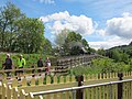
 Boundary stone - geograph.org.uk - 3213604.jpg 1,600 × 1,200; 696 KB
-

-
 Bracken take over - geograph.org.uk - 3035290.jpg 1,600 × 1,200; 567 KB
-

-
 Bridge over Afon Dyfrdwy - geograph.org.uk - 1671460.jpg 640 × 428; 90 KB
-
 Bridge over the Dee, Corwen.jpeg 900 × 700; 383 KB
-
 Bridge, signal and siding - geograph.org.uk - 4117479.jpg 640 × 480; 101 KB
-
 Bridle path across the heather - geograph.org.uk - 3213648.jpg 1,600 × 1,200; 266 KB
-
 Bridleway towards Rhewl - geograph.org.uk - 2917417.jpg 1,600 × 1,200; 446 KB
-

-
 Bungalow called Mynydd Llwyd - geograph.org.uk - 2913383.jpg 1,600 × 1,200; 402 KB
-
 Caefaes, Corwen - geograph.org.uk - 1612148.jpg 640 × 426; 60 KB
-
 Cairn on the Berwyns - geograph.org.uk - 1291217.jpg 640 × 428; 65 KB
-
 Cairn on the summit of Caer Drewyn - geograph.org.uk - 1811576.jpg 640 × 480; 64 KB
-
 Canoes ^ cabins beside the river - geograph.org.uk - 2913331.jpg 1,600 × 1,200; 679 KB
-
 Carpet of pine needles - geograph.org.uk - 3213760.jpg 1,600 × 1,200; 503 KB
-
 Cattle and sheep grazing - geograph.org.uk - 1918824.jpg 640 × 428; 70 KB
-
 Cattle Grid at the edge of the forest - geograph.org.uk - 3554624.jpg 640 × 480; 158 KB
-
 Cattle shed at Fedw Ucha - geograph.org.uk - 2938944.jpg 1,600 × 1,200; 267 KB
-
 Cattle sulking - geograph.org.uk - 4127362.jpg 640 × 480; 132 KB
-
 Cefn Rug - geograph.org.uk - 3176030.jpg 640 × 430; 45 KB
-
 Churn stand at the end of a farm road - geograph.org.uk - 1918869.jpg 1,600 × 1,071; 627 KB
-
 Coed-y-glyn farmhouse - geograph.org.uk - 2913366.jpg 1,600 × 1,200; 448 KB
-
 Community sheep and cattle handling pens - geograph.org.uk - 1918987.jpg 1,600 × 1,071; 421 KB
-

-

-
 Corwen East station - exit ramp (geograph 5576102).jpg 1,024 × 768; 217 KB
-
 Corwen East Station Beside the River Dee - geograph.org.uk - 4927027.jpg 640 × 480; 174 KB
-
 Corwen East Station in Denbighshire - geograph.org.uk - 5172949.jpg 768 × 1,024; 366 KB
-
 Corwen East Station platform - geograph.org.uk - 4927030.jpg 640 × 480; 165 KB
-
 Cottage called Hên-Alwen - geograph.org.uk - 1918645.jpg 640 × 428; 97 KB
-
 Cottage high above the Dee Valley - geograph.org.uk - 2507880.jpg 640 × 480; 115 KB
-

-
 Coupling up at Carrog - geograph.org.uk - 4927122.jpg 480 × 640; 187 KB
-
 Coupling up before departure - geograph.org.uk - 4148918.jpg 480 × 640; 72 KB
-

-
 Creigiau Llangar - geograph.org.uk - 3039054.jpg 1,600 × 1,200; 504 KB
-
 Cross fence on the map - geograph.org.uk - 3213584.jpg 1,600 × 1,200; 486 KB
-
-
 Crossing the Dee - panoramio.jpg 2,592 × 1,944; 1.27 MB
-
 Crossing the valley - geograph.org.uk - 2921142.jpg 1,600 × 1,200; 521 KB
-
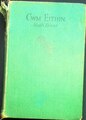 Cwm Eithin.djvu 1,844 × 2,579, 261 pages; 30.66 MB
-
 Cwm Nant-y-Pandy - geograph.org.uk - 3549481.jpg 640 × 480; 108 KB
-
 Cwm-tydi across the valley - geograph.org.uk - 2921200.jpg 1,600 × 1,200; 305 KB
-
 Cwm-tydi from under the conifers - geograph.org.uk - 2921100.jpg 1,600 × 1,200; 759 KB
-
 Cynwyd LL21, UK - panoramio.jpg 2,448 × 3,264; 2.89 MB
-
 Dee Valley East of Corwen - geograph.org.uk - 3169984.jpg 3,264 × 2,448; 2.36 MB
-
 Departing from Carrog - geograph.org.uk - 4927157.jpg 640 × 480; 134 KB
-
 Departing from Glyndyfrdwy - geograph.org.uk - 4927232.jpg 640 × 480; 181 KB
-
 Derelict cotter house at Nant-y-madwen - geograph.org.uk - 1659320.jpg 640 × 424; 106 KB
-

-

-
 Derelict slab mill buildings - geograph.org.uk - 3547760.jpg 640 × 480; 106 KB
-
 Derelict upland building - geograph.org.uk - 3036333.jpg 1,600 × 1,200; 375 KB
-
 Descent from Caer Drewyn - geograph.org.uk - 1811587.jpg 640 × 480; 68 KB
-

-

-

-

-
 Diesel units at Glyndyfrdwy in Denbighshire - geograph.org.uk - 5183240.jpg 1,280 × 858; 570 KB
-
 Disused buildings, Carreg-Afon - geograph.org.uk - 3547733.jpg 640 × 480; 94 KB
-
 Dolawen farm - geograph.org.uk - 1918672.jpg 1,600 × 1,071; 449 KB
-
 Dropping down towards Cymmo - geograph.org.uk - 2915194.jpg 1,600 × 1,200; 703 KB
-
 Dry Stone Wall - geograph.org.uk - 170563.jpg 640 × 480; 156 KB
-
 Dumped beside a woodland track - geograph.org.uk - 3554654.jpg 640 × 480; 185 KB
-
 Dwyrain Corwen East on the Llangollen Railway - geograph.org.uk - 4616140.jpg 2,184 × 1,456; 1.13 MB
-

-

-

-
 Edge of the forest - geograph.org.uk - 2970934.jpg 1,600 × 1,071; 613 KB
-
 Edge of the world - geograph.org.uk - 3405269.jpg 640 × 426; 72 KB
-

-
 Entering Carrog Station in Denbighshire - geograph.org.uk - 5171874.jpg 1,024 × 723; 567 KB
-
 Entering Glyndyfrdwy Station - geograph.org.uk - 4927218.jpg 640 × 480; 221 KB
-
 Entrance to a back lane - geograph.org.uk - 1923502.jpg 1,600 × 1,071; 670 KB
-
 Entrance to Carrog Station - geograph.org.uk - 4148877.jpg 640 × 480; 86 KB
-
 Extensive upland grazing - geograph.org.uk - 1923650.jpg 1,600 × 1,071; 445 KB
-
 Extensive upland grazing - geograph.org.uk - 3213593.jpg 1,600 × 1,200; 453 KB
-
 Farm building by the A5, Glyndyfrdwy - geograph.org.uk - 3126941.jpg 640 × 413; 65 KB
-
 Farm buildings at Cwm Canol - geograph.org.uk - 3360882.jpg 1,600 × 1,200; 610 KB
-
 Farm buildings at Cwm Isaf - geograph.org.uk - 3360720.jpg 1,600 × 1,200; 353 KB
-

-
 Farm Shop - geograph.org.uk - 2408998.jpg 2,560 × 1,920; 2.04 MB
-
 Farm steading at Fedw Ucha - geograph.org.uk - 2938916.jpg 1,600 × 1,200; 319 KB
-
 Farm steading at Fron-newydd - geograph.org.uk - 2938845.jpg 1,600 × 1,200; 485 KB
-
 Farm track towards Wern-ddu - geograph.org.uk - 2921226.jpg 1,600 × 1,200; 526 KB
-

-
 Farmhouse at Nant-y-madwen - geograph.org.uk - 1659332.jpg 640 × 396; 100 KB
-
 Farmhouse at Ty'n-y-celyn - geograph.org.uk - 1918901.jpg 1,600 × 1,071; 491 KB
-
 Farmhouse by the A5 - geograph.org.uk - 3126961.jpg 640 × 386; 77 KB
-

-

-

-

-

-

-
 Farmland by the A5 - geograph.org.uk - 3177438.jpg 640 × 430; 56 KB
-
 Farmland in the Dee Valley - geograph.org.uk - 3181355.jpg 640 × 430; 71 KB
-
 Farmland near Carrog in Denbighshire - geograph.org.uk - 5173915.jpg 1,280 × 792; 813 KB
-

-

-

-

-
 Farmland near Druid - geograph.org.uk - 2870232.jpg 3,264 × 2,448; 4.38 MB
-
 Farmland west of Glyndyfrdwy in Denbighshire - geograph.org.uk - 5181861.jpg 1,280 × 832; 807 KB
-
 Farmland west of Glyndyfrdwy, Denbighshire - geograph.org.uk - 5170924.jpg 1,280 × 772; 523 KB
-
 Farmland west of Glyndyfrdwy, Denbighshire - geograph.org.uk - 5170929.jpg 1,280 × 820; 748 KB
-
 Feeding the pregnant ewes - geograph.org.uk - 2919167.jpg 1,600 × 1,200; 524 KB
-
 Felled timber at High Park woods - geograph.org.uk - 1808963.jpg 640 × 480; 114 KB
-
 Fenced or open upland - geograph.org.uk - 2921034.jpg 1,600 × 1,200; 355 KB
-
 Field boundary - geograph.org.uk - 1862485.jpg 640 × 480; 98 KB
-
 Field of oats near Corwen - geograph.org.uk - 3157523.jpg 640 × 480; 108 KB
-
 Field of oats near Corwen - geograph.org.uk - 3157529.jpg 640 × 480; 122 KB
-
 Flat valley floor, steep valley side - geograph.org.uk - 1878742.jpg 1,024 × 768; 138 KB
-
 Flood plain of Afon Dyfrdwy - geograph.org.uk - 2913220.jpg 1,600 × 1,200; 386 KB
-
 Floodplain of the Afon Dyfrdwy at Corwen - geograph.org.uk - 2857467.jpg 1,600 × 1,200; 318 KB


_-_geograph.org.uk_-_2181621.jpg)


.jpg)


&filefrom=Flower+bed+and+pasture+at+Carrog+Station%2C+Denbighshire+-+geograph.org.uk+-+5172217.jpg#mw-category-media)