Category:Creu de Sant Pere del Bosc
Jump to navigation
Jump to search
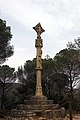
This is a category about a building indexed in the Catalan heritage register as Bé Cultural d'Interès Local (BCIL) under the reference IPA-26824. |
| Object location | | View all coordinates using: OpenStreetMap |
|---|
 | |||||
| Upload media | |||||
| Instance of | |||||
|---|---|---|---|---|---|
| Location | Lloret de Mar, Selva, Comarques Gironines, Catalonia | ||||
| Street address |
| ||||
| Architectural style | |||||
| Heritage designation |
| ||||
 | |||||
Subcategories
This category has only the following subcategory.
Media in category "Creu de Sant Pere del Bosc"
The following 7 files are in this category, out of 7 total.
-
 Creu de Sant Pere del Bosc (2016).jpg 3,286 × 2,432; 3.62 MB
-
 Creu del Terme i Sant Pere del Bosc, Lloret de Mar (maig 2013) - panoramio.jpg 3,648 × 2,736; 5.02 MB
-
 Cross Lloret.JPG 1,536 × 2,048; 673 KB
-
 Lloret de Mar, Sant pere del Bosc, Kreuz (1).JPG 3,264 × 4,928; 7.91 MB
-
 Lloret de Mar, Sant pere del Bosc, Kreuz.JPG 4,928 × 3,264; 7.93 MB
-
 LLRT-PiC-creuterme-2801-01.jpg 800 × 1,200; 303 KB
-
 LLRT-PiC-creuterme-tetramorf-2820-01.jpg 1,200 × 800; 166 KB
.jpg)
_-_panoramio.jpg)

.JPG)

