Category:Croix de Landoma
Jump to navigation
Jump to search
| Object location | | View all coordinates using: OpenStreetMap |
|---|
|
This building is inscrit au titre des monuments historiques de la France. It is indexed in the base Mérimée, a database of architectural heritage maintained by the French Ministry of Culture, under the reference PA00091479
|
| Object location | | View all coordinates using: OpenStreetMap |
|---|
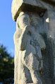
wayside cross located in Morbihan, in France  | |||||
| Upload media | |||||
| Pronunciation audio | |||||
|---|---|---|---|---|---|
| Instance of | |||||
| Location | Pleugriffet, canton of Rohan | ||||
| Heritage designation |
| ||||
 | |||||
Media in category "Croix de Landoma"
The following 6 files are in this category, out of 6 total.
-
 Croix de Landoma 5480.JPG 3,456 × 5,184; 4.3 MB
-
 Croix de Landoma 5481.JPG 3,396 × 5,144; 5.71 MB
-
 Croix de Landoma 5483.JPG 3,454 × 5,184; 8.42 MB
-
 Croix de Landoma 5484.JPG 3,456 × 5,184; 4.73 MB
-
 Croix de Landoma 5486.JPG 3,352 × 5,116; 5.72 MB
-
 Croix de Landoma 5487.JPG 3,456 × 5,184; 4.43 MB


