Category:Cumberland Plateau
Vai alla navigazione
Vai alla ricerca
plateau in the United States  | |||||
| Carica un file multimediale | |||||
| Istanza di | |||||
|---|---|---|---|---|---|
| Parte di |
| ||||
| Luogo | |||||
 | |||||
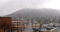
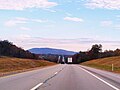
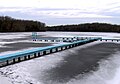
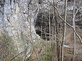
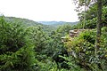
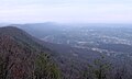
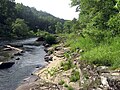
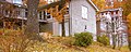
Files related to the Cumberland Plateau, a landform in the U.S. states of Kentucky, Tennessee, Georgia, and Alabama.
Sottocategorie
Questa categoria contiene le 12 sottocategorie indicate di seguito, su un totale di 12.
B
C
F
G
- Grassy Cove (11 F)
O
P
R
S
- Scott's Gulf (8 F)
- Sequatchie Valley (12 F)
T
- Tennessee River Gorge (8 F)
File nella categoria "Cumberland Plateau"
Questa categoria contiene 44 file, indicati di seguito, su un totale di 44.
-
 Bedrock mortar in a rock shelter on the Upper Cumberland Plateau.jpg 5 323 × 3 563; 13,51 MB
-
 Black-mountain-slopes-east-tn1.jpg 1 148 × 857; 306 KB
-
 Blount-county-cumberland-plateau.jpg 1 193 × 600; 379 KB
-
 Briceville-slatestone-road-cross-mtn-tn1.jpg 2 932 × 1 759; 1,47 MB
-
 County-Highway-98-Jackson-al1.jpg 4 000 × 3 000; 4,37 MB
-
 Crab Orchard Mountain Peaks.svg 962 × 845; 4,99 MB
-
 Cuesta - Lookout Mountain, Georgia.png 842 × 676; 1,31 MB
-
 Cumberland Plateau in NW Georgia.jpg 1 200 × 900; 584 KB
-
 Cumberland-plateau-i40-tn1.jpg 1 200 × 894; 173 KB
-
 Dayton-Tennessee-from-Cedar-Hill-tn1.jpg 4 244 × 2 794; 1,73 MB
-
 East-fork-obey-river-tn1.jpg 4 000 × 2 626; 4,3 MB
-
 East-tennessee-landforms.png 434 × 264; 238 KB
-
 Emory-river-nemo-tn1.jpg 3 940 × 2 911; 4,49 MB
-
 Fentress-county-cumberland-plateau-tn1.jpg 1 340 × 707; 525 KB
-
 Harriman-crescent-ave-walden-ridge-tn1.jpg 1 783 × 964; 788 KB
-
 I-40 east Crab Orchard Mountains.jpg 4 000 × 3 000; 1,16 MB
-
 I-40 east Walden Ridge.jpg 3 655 × 2 742; 1,28 MB
-
 Lake-mayland-camp-nakanawa-tn1.jpg 2 035 × 1 424; 1,22 MB
-
 Limestoneshale7342.jpg 300 × 225; 30 KB
-
 Lone-mountain-tn2.jpg 1 612 × 860; 411 KB
-
 Lost Cove Cave From Cliff.jpg 4 000 × 3 000; 4,84 MB
-
 Monte Sano State Park Lodge Overlook.jpg 3 984 × 2 656; 2,36 MB
-
 Nine-Mile-Bledsoe-tn1.jpg 4 000 × 3 000; 3,43 MB
-
 Oil-pump-rugby-tn1.jpg 2 896 × 2 115; 2,66 MB
-
 Oliver-springs-walden-tn1.jpg 1 867 × 1 297; 706 KB
-
 Pelham-powerlines-tn1.jpg 3 712 × 2 850; 4,09 MB
-
 Roane-walden-ridge-tn1.jpg 1 995 × 1 205; 325 KB
-
 Sandstone Riverscour Cumberland Plateau.jpg 3 072 × 2 304; 2,87 MB
-
 Sparta-overlook-tn4.jpg 3 565 × 2 160; 1,05 MB
-
 St Marys Convent at Sewanee Tennessee.jpg 2 845 × 1 130; 3,49 MB
-
 State-Route-277-Bridgeport-al1.jpg 4 000 × 2 225; 4,06 MB
-
 Tennessee-highway-111-spencer-tn1.jpg 3 466 × 2 218; 2,4 MB
-
 The W Signal Mountain, near Chattanooga, Tennessee (65877).jpg 3 339 × 2 140; 2,63 MB
-
 US-27-Evensville-tn1.jpg 3 956 × 2 528; 1,64 MB
-
 US-41A-Cumberland-Plateau-tn1.jpg 3 718 × 2 462; 2,96 MB
-
 US-70-overlook-sparta-tn1.jpg 3 840 × 2 160; 1,48 MB
-
 US-70-overlook-sparta-tn3.jpg 3 840 × 2 160; 1,61 MB
-
 US-70-sparta-overlook-tn2.jpg 3 840 × 2 160; 1,27 MB
-
 Valley-view-farm-tn1.jpg 3 660 × 2 361; 3,07 MB
-
 Walden-ridge-roosevelt-tn1.jpg 2 045 × 1 533; 645 KB
-
 Whitwell-Cumberland-Plateau-tn1.jpg 3 860 × 2 827; 1,62 MB
-
 Whitwell-TN28-TN283-tn1.jpg 4 000 × 3 000; 2,4 MB
-
 Wilderness Road (Cumberland Mtns) TN.jpg 7 871 × 2 074; 2,78 MB
-
 WV plateau.jpg 800 × 784; 472 KB


.jpg)


_TN.jpg)