Category:Danby Dale, North Yorkshire
Jump to navigation
Jump to search
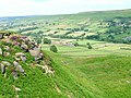
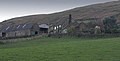
English: Danby Dale, valley in civil parish of Danby, southern arm of Eskdale, south of Castleton and Danby, Castleton Rigg to west, Danby Rigg to east
Subcategories
This category has the following 2 subcategories, out of 2 total.
B
- Botton, North Yorkshire (15 F)
S
Media in category "Danby Dale, North Yorkshire"
The following 48 files are in this category, out of 48 total.
-
 Barn, North End Farm - geograph.org.uk - 1741659.jpg 640 × 427; 298 KB
-
 Blackmires - geograph.org.uk - 1732490.jpg 640 × 427; 378 KB
-
 Castleton Rig - geograph.org.uk - 122027.jpg 640 × 371; 46 KB
-
 Cattle grid in Danby Dale - geograph.org.uk - 129957.jpg 640 × 425; 70 KB
-
 Didderhowe, Danby Dale - geograph.org.uk - 1744505.jpg 640 × 427; 117 KB
-
 Didderhowe, Danby Dale - geograph.org.uk - 1744510.jpg 640 × 427; 127 KB
-
 East Cliff, Danby Dale - geograph.org.uk - 1744892.jpg 427 × 640; 293 KB
-
 Entrance to Lumley House - geograph.org.uk - 1638070.jpg 640 × 480; 111 KB
-
 Esk Valley Way - geograph.org.uk - 1744498.jpg 427 × 640; 120 KB
-
 Forest Farm, Danby Dale - geograph.org.uk - 1744504.jpg 640 × 427; 132 KB
-
 Gate, Danby Dale - geograph.org.uk - 1744507.jpg 427 × 640; 151 KB
-
 Gateposts, Danby Dale - geograph.org.uk - 1732662.jpg 427 × 640; 300 KB
-
 Grey Stones - geograph.org.uk - 810351.jpg 640 × 427; 251 KB
-
 Intake Fields, Danby Dale - geograph.org.uk - 1732614.jpg 427 × 640; 301 KB
-

-

-
 Pasture Fields, Near Botton Grove - geograph.org.uk - 1732587.jpg 427 × 640; 308 KB
-
 Runners in the Fox and Hounds Race - geograph.org.uk - 167426.jpg 640 × 480; 126 KB
-

-
 Snowdrops, Danby Dale - geograph.org.uk - 1744901.jpg 427 × 640; 310 KB
-
 St Hildas and Church House (farm) - geograph.org.uk - 113179.jpg 640 × 427; 66 KB
-
 St. Hilda's Church, Danby Dale - geograph.org.uk - 1732626.jpg 640 × 427; 309 KB
-
 Stonebeck Gate Cottage - geograph.org.uk - 211482.jpg 640 × 427; 72 KB
-
 Stormy Hall - geograph.org.uk - 1732576.jpg 640 × 427; 285 KB
-

-
 West Green Farm - geograph.org.uk - 1732606.jpg 640 × 427; 269 KB
-
 Wheely Bin Parade - geograph.org.uk - 148492.jpg 640 × 427; 67 KB
-
 A small wood in Danby dale - geograph.org.uk - 148505.jpg 640 × 427; 71 KB
-
 Castleton from Danby dale - geograph.org.uk - 113190.jpg 640 × 427; 70 KB
-
 Crag House Farm - geograph.org.uk - 148486.jpg 640 × 427; 90 KB
-
 Danby Dale - geograph.org.uk - 23592.jpg 640 × 480; 79 KB
-
 Danby Rigg, North York Moors - geograph.org.uk - 544440.jpg 640 × 477; 166 KB
-
 Falcon Farm - Botton - geograph.org.uk - 148502.jpg 640 × 427; 78 KB
-
 Forest Farm in Danby Dale - geograph.org.uk - 148481.jpg 640 × 427; 77 KB
-
 Honey Bee Nest, Danby Head - geograph.org.uk - 23580.jpg 640 × 480; 78 KB
-

-
 Lumley House - geograph.org.uk - 113174.jpg 640 × 427; 58 KB
-
 Nook House Farm, Danby Head - geograph.org.uk - 23594.jpg 640 × 480; 87 KB
-
 Plum Tree Farm, Danby Dale - geograph.org.uk - 100247.jpg 640 × 402; 37 KB
-
 Road to West Green and Plum Tree Farm - geograph.org.uk - 148488.jpg 640 × 427; 41 KB
-
 Silage Bales near West Green Farm - geograph.org.uk - 309444.jpg 640 × 427; 77 KB
-
 St Helena, Danby Head - geograph.org.uk - 23723.jpg 640 × 480; 75 KB
-
 Stormy Hall, Danby Dale - geograph.org.uk - 23581.jpg 640 × 480; 67 KB
-
 Sycamore House - geograph.org.uk - 309440.jpg 640 × 427; 79 KB
-
 The chapel near Botton village - geograph.org.uk - 129954.jpg 640 × 427; 62 KB
-
 TV antennas Danby Dale - geograph.org.uk - 113167.jpg 640 × 427; 70 KB
-
 West Green Farm - geograph.org.uk - 309441.jpg 640 × 325; 51 KB
-
 West Green Farm and Sycamore House - geograph.org.uk - 23583.jpg 640 × 480; 58 KB


.jpg)


_-_geograph.org.uk_-_113179.jpg)


