Category:Daniel Boone Apartments (Boonville, Missouri)
Jump to navigation
Jump to search
| Object location | | View all coordinates using: OpenStreetMap |
|---|
building in Missouri, United States  | |||||
| Upload media | |||||
| Instance of | |||||
|---|---|---|---|---|---|
| Location | Missouri | ||||
| Heritage designation | |||||
 | |||||
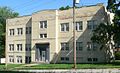
Listed in the National Register of Historic Places as "Sumner Public School". There is a second "Sumner Public School" building in Boonville, on Rural Street; as of 2015, it was occupied by Concerned Citizens for the Black Community. The two should not be confused.
|
This is a category about a place or building that is listed on the National Register of Historic Places in the United States of America. Its reference number is 82005331. |
Media in category "Daniel Boone Apartments (Boonville, Missouri)"
The following 5 files are in this category, out of 5 total.
-
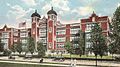 CentralHighSchoolStLouis1918postcard.jpg 695 × 387; 165 KB
-
 Daniel Boone Apartments from SE 1.JPG 2,023 × 1,234; 674 KB
-
 Daniel Boone Apartments from SE 2.JPG 2,078 × 1,196; 658 KB
-
 Daniel Boone Apartments from SSW 1.JPG 1,959 × 1,212; 589 KB
-
 Daniel Boone Apartments front entrance 1.JPG 2,275 × 1,775; 864 KB


