Category:De Kersenboom
Jump to navigation
Jump to search
| Object location | | View all coordinates using: OpenStreetMap |
|---|
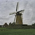
windmill in Rijsoord, Netherlands  | |||||
| Upload media | |||||
| Instance of |
| ||||
|---|---|---|---|---|---|
| Location | Rijsoord, South Holland, Netherlands | ||||
| Street address |
| ||||
| Located on street |
| ||||
| Has use | |||||
| Heritage designation |
| ||||
| Inception |
| ||||
| Source of energy | |||||
 | |||||
|
This is a category about rijksmonument number 32519
|
| Address |
|
Media in category "De Kersenboom"
The following 15 files are in this category, out of 15 total.
-
 Exterieur AFGEVALLEN HEKWERK - Rijsoord - 20290125 - RCE.jpg 1,200 × 1,200; 365 KB
-
 Exterieur BUITENROEDE GEBROKEN - Rijsoord - 20290123 - RCE.jpg 1,200 × 1,200; 230 KB
-
 Exterieur BUITENROEDE GEBROKEN - Rijsoord - 20290124 - RCE.jpg 1,200 × 1,186; 263 KB
-
 Exterieur KRUIHASPEL EN VERROTTE STAART - Rijsoord - 20290126 - RCE.jpg 1,200 × 1,200; 343 KB
-
 Korenmolen "De Kersenboom" - Rijsoord - 20187585 - RCE.jpg 1,200 × 1,179; 212 KB
-
 Korenmolen "De Kersenboom" - Rijsoord - 20187586 - RCE.jpg 1,200 × 1,176; 331 KB
-
 Korenmolen "De Kersenboom" - Rijsoord - 20187587 - RCE.jpg 1,200 × 1,179; 226 KB
-
 Korenmolen "De Kersenboom" - Rijsoord - 20187588 - RCE.jpg 1,200 × 1,188; 255 KB
-
 Korenmolen "De Kersenboom", overzicht - Rijsoord - 20187589 - RCE.jpg 1,200 × 1,200; 251 KB
-
 Korenmolen De Kersenboom, exterieur - Rijsoord - 20187590 - RCE.jpg 1,200 × 1,200; 496 KB
-
 Korenmolen Waaldijk 1a, aanzicht (1822) - Rijsoord - 20187584 - RCE.jpg 811 × 1,200; 218 KB
-
 Molen De Kersenboom Rijsoord 11-8-2007 - panoramio.jpg 850 × 638; 114 KB
-
 Overzicht - Rijsoord - 20376652 - RCE.jpg 1,200 × 1,200; 253 KB
-
 Rijsoord molen De Kersenboom foto 2.jpg 1,400 × 2,100; 1.36 MB
-
 Rijsoord molen De Kersenboom.jpg 2,100 × 1,400; 1.43 MB


_-_Rijsoord_-_20187584_-_RCE.jpg)


