Category:De Klinze (Aldtsjerk)
Jump to navigation
Jump to search
| Object location | | View all coordinates using: OpenStreetMap |
|---|
building in Tytsjerksteradiel, Netherlands  | |||||
| Upload media | |||||
| Instance of | |||||
|---|---|---|---|---|---|
| Part of | |||||
| Location | Aldtsjerk, Tytsjerksteradiel, Friesland, Netherlands | ||||
| Street address |
| ||||
| Located on street |
| ||||
| Heritage designation |
| ||||
 | |||||
|
This is a category about rijksmonumentcomplex number 529158
|
Landhuis
|
This is a category about rijksmonument number 529159
|
Historische aanleg
|
This is a category about rijksmonument number 529160
|
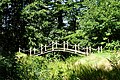
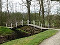
Brug
|
This is a category about rijksmonument number 529161
|
Prieel
|
This is a category about rijksmonument number 529163
|
Koetshuis
|
This is a category about rijksmonument number 529164
|
Tuinmanswoning
|
This is a category about rijksmonument number 529165
|
Orangerie
|
This is a category about rijksmonument number 529166
|
Hekken
|
This is a category about rijksmonument number 529167
|
Toegangshekken
|
This is a category about rijksmonument number 529168
|
| Address |
|
Media in category "De Klinze (Aldtsjerk)"
The following 23 files are in this category, out of 23 total.
-
 20200902 De Klinze door Jacobus Stellingwerff 1722 Aldtsjerk.jpg 2,178 × 1,439; 537 KB
-
 20200902 De Klinze1 Aldtsjerk.jpg 5,184 × 3,456; 4.05 MB
-
 20200902 De Klinze2 Aldtsjerk.jpg 5,184 × 3,456; 3.73 MB
-
 20200902 De Klinze3 Aldtsjerk.jpg 5,184 × 3,456; 4.92 MB
-
 20200902 De Klinze4 Aldtsjerk.jpg 5,184 × 3,456; 5.52 MB
-
 20210615 De Klinze1 Aldtsjerk.jpg 4,727 × 3,151; 3.34 MB
-
 20210615 De Klinze2 Aldtsjerk.jpg 5,184 × 3,456; 5.24 MB
-
 Achtergevel - Oudkerk - 20180339 - RCE.jpg 1,200 × 960; 367 KB
-
 Achtergevel koetshuis - Oudkerk - 20180340 - RCE.jpg 1,200 × 948; 292 KB
-
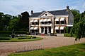 De Klinze.JPG 3,008 × 2,000; 5.2 MB
-
 Detail schouw in linker voorkamer - Oudkerk - 20180344 - RCE.jpg 953 × 1,200; 279 KB
-

-

-
 Koetshuis De Klinze.JPG 3,008 × 2,000; 5.12 MB
-
 Oudkerk De Klinze Brug.JPG 4,000 × 3,000; 7.18 MB
-
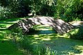
 Oudkerk De Klinze Parkaanleg.JPG 4,000 × 3,000; 7.13 MB
-
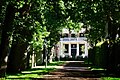
 Oudkerk De Klinze.JPG 4,000 × 3,000; 6.47 MB
-
 Overzicht - Oudkerk - 20180336 - RCE.jpg 1,200 × 954; 426 KB
-
 Overzicht - Oudkerk - 20180337 - RCE.jpg 1,200 × 950; 283 KB
-
 Overzicht voorgevel en linker zijgevel, landhuis - Oudkerk - 20345870 - RCE.jpg 1,193 × 1,200; 345 KB
-
 Prieel bij De Klinze.JPG 3,008 × 2,000; 6.23 MB
-

-
 Voorgevel - Oudkerk - 20180338 - RCE.jpg 1,200 × 949; 273 KB


