Category:De Tenellaplas
Jump to navigation
Jump to search
| Object location | | View all coordinates using: OpenStreetMap |
|---|
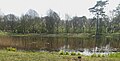
Nederlands: De Tenellaplas is een meer in de duinen tussen Rockanje en Oostvoorne, waarbij een heemtuin is aangelegd. De Tenellaplas ligt niet ver van het Voornes Duin.
English: De Tenellaplas is a wildlife garden in the Netherlands, near Rockanje.
park in the Netherlands  | |||||
| Upload media | |||||
| Instance of | |||||
|---|---|---|---|---|---|
| Location | Rockanje, Westvoorne, South Holland, Netherlands | ||||
 | |||||
Subcategories
This category has only the following subcategory.
B
- Bezoekerscentrum Tenellaplas (3 F)
Media in category "De Tenellaplas"
The following 23 files are in this category, out of 23 total.
-
 20170409 Tenellaplas 01.jpg 3,537 × 2,653; 3.15 MB
-
 20170409 Tenellaplas 02.jpg 3,504 × 2,166; 2.81 MB
-
 20170409 Tenellaplas 03.jpg 3,560 × 2,303; 2.35 MB
-
 20170409 Tenellaplas 04.jpg 3,553 × 2,665; 2.88 MB
-
 20170409 Tenellaplas 05.jpg 3,569 × 2,677; 4.06 MB
-
 20170409 Tenellaplas 06.jpg 3,577 × 2,683; 4.13 MB
-
 20170409 Tenellaplas 07.jpg 3,648 × 2,736; 2.34 MB
-
 20170409 Tenellaplas 11.jpg 2,736 × 2,948; 6.69 MB
-
 20170409 Tenellaplas 12.jpg 2,644 × 2,743; 5.68 MB
-
 20170409 Tenellaplas 13.jpg 2,736 × 3,648; 4.03 MB
-
 20170409 Tenellaplas 14.jpg 2,736 × 3,648; 4.53 MB
-
 20170409 Tenellaplas 15.jpg 2,736 × 3,648; 5.2 MB
-
 20170409 Tenellaplas 16.jpg 2,736 × 3,648; 5.21 MB
-
 20170409 Tenellaplas 17.jpg 3,648 × 2,736; 2.06 MB
-
 20170409 Tenellaplas 18.jpg 2,736 × 3,648; 4.48 MB
-
 20170409 Tenellaplas 21.jpg 5,283 × 2,518; 8.89 MB
-
 20170409 Tenellaplas 22.jpg 4,557 × 2,305; 7.23 MB
-
 Euphorbia cyparissias bloemen.jpg 2,048 × 1,536; 1.36 MB
-
 Euphorbia cyparissias bloemhoofd.jpg 1,536 × 2,048; 1.22 MB
-
 Euphorbia cyparissias overzicht.jpg 2,048 × 1,536; 1.26 MB
-
 Orobanche gracilis -Tenellaplas.jpg 1,704 × 2,272; 1.04 MB
-
 Tenellaplas 29-1-2012 - panoramio.jpg 980 × 731; 256 KB
-
 Tenellaplas, Oostvoorne.JPG 3,264 × 2,448; 3.9 MB


