Category:Death Place of Roxas historical marker
Jump to navigation
Jump to search
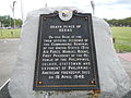
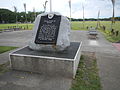
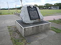
NHCP historical marker for the site of Manuel Roxas’ death  | |||||
| Upload media | |||||
| Instance of | |||||
|---|---|---|---|---|---|
| Commemorates | |||||
| Location | Stotsenburg Park, Clark Freeport and Special Economic Zone, Angeles, Central Luzon, PH | ||||
| Street address |
| ||||
| Creator | |||||
| Inception |
| ||||
 | |||||
Media in category "Death Place of Roxas historical marker"
The following 12 files are in this category, out of 12 total.
-
 1224Death Place of Manuel Roxasfvf 01.JPG 4,608 × 3,456; 5.36 MB
-
 1224Death Place of Manuel Roxasfvf 02.JPG 4,608 × 3,456; 5.81 MB
-
 1224Death Place of Manuel Roxasfvf 03.JPG 4,608 × 3,456; 5.79 MB
-
 1224Death Place of Manuel Roxasfvf 04.JPG 4,608 × 3,456; 5.89 MB
-
 1224Death Place of Manuel Roxasfvf 05.JPG 4,608 × 3,456; 6.02 MB
-
 1224Death Place of Manuel Roxasfvf 06.JPG 4,608 × 3,456; 5.81 MB
-
 1224Death Place of Manuel Roxasfvf 07.JPG 4,608 × 3,456; 5.92 MB
-
 1224Death Place of Manuel Roxasfvf 08.JPG 4,608 × 3,456; 6.43 MB
-
 1224Death Place of Manuel Roxasfvf 09.JPG 4,608 × 3,456; 6.55 MB
-
 1224Death Place of Manuel Roxasfvf 10.JPG 4,608 × 3,456; 6.67 MB
-
 1224Death Place of Manuel Roxasfvf 11.JPG 4,608 × 3,456; 6.79 MB
-
 Death Place of Roxas historical marker.jpg 2,000 × 3,105; 1.54 MB


