Category:Details of old maps, defaced
Jump to navigation
Jump to search
English: This category is for cutouts of old maps where modern markings have been added to point out the detail of interest.
Media in category "Details of old maps, defaced"
The following 200 files are in this category, out of 375 total.
(previous page) (next page)-
 1 Basil Normans Land Grant Lot 1281 on original map - LARGE copy.jpg 9,955 × 5,600; 21.8 MB
-
 1.Butterfield Overland Mail North of Springfield.png 1,588 × 1,035; 3.58 MB
-
 1.Clever Missouri Old Wire Road.png 1,444 × 692; 2.42 MB
-
 1.StateLine thru Battlefield.png 1,484 × 627; 2.26 MB
-
 10.Forkners Hill Webster Co.png 1,551 × 766; 2.71 MB
-
 11.Marshfield to Niangua.png 1,305 × 848; 2.68 MB
-
 Aug Emerita.png 1,503 × 1,016; 887 KB
-
 12.NianguaNE into Wright County.png 1,319 × 776; 2.4 MB
-
 14 PA Cav in Virginia Nov 1864.png 684 × 563; 790 KB
-
 14 PA Cav Late September 1864.png 526 × 677; 705 KB
-
 14 PA Cavalry - Early 1863.png 1,067 × 479; 1.24 MB
-
 Carta nautica del Mar Nero 1436 by Andrea Bianco.jpg 1,062 × 833; 255 KB
-
 1513 Quarta Europae Tabula FLEVVM.jpg 554 × 405; 295 KB
-
 Hof van Gistel.jpg 471 × 427; 125 KB
-
 Ehrenstraße-und-Kloster-St-Apern-Köln-Mercator-1571.jpg 474 × 506; 132 KB
-
 Asiae-IX map Mercator 1578 Alexandria Carmaniae - Annotated.jpg 1,146 × 1,272; 1.21 MB
-
 Antonio Lafreri, 1512 - 1577.jpg 800 × 758; 153 KB
-
 Усть-Пинега голландская карта 1600 год.jpg 984 × 802; 44 KB
-
 Sigizmundian Plan of Moscow. Fragment1.jpg 545 × 545; 337 KB
-
 Hessel Gerritsz, Map of Sumatra showing Pedra Branca (1620).jpg 497 × 628; 105 KB
-

-
 Map of Moscow by Matthäus Merian. Fragment1.jpg 570 × 570; 357 KB
-
 Карта Blaeu 1645 года.jpg 1,856 × 948; 831 KB
-
 Gut Nienhagen im Hochstift Hildesheim.jpg 1,081 × 1,089; 603 KB
-
 Rotkowcze.jpg 424 × 285; 79 KB
-
 Vcb.png 943 × 652; 625 KB
-
 Боплан Ольшана.jpg 500 × 389; 74 KB
-
 Боплан Район.jpg 500 × 389; 74 KB
-
 Краснопіль (Великі Сорочинці) на карті Боплана 1648 року.jpg 748 × 504; 110 KB
-
 Gerhard Mercator, amsterdam - Dioscuria, Georgia - 1690.jpg 800 × 600; 137 KB
-
 Visscher, Nicolaes, 1649-1702., 1690, amsterdam.jpg 1,200 × 1,129; 245 KB
-
 Старая карта, фрагмент.JPG 609 × 546; 113 KB
-
 1692 – “La Russie blanche ou Moscovie Alexis-Hubert Jaillot (París).jpg 1,664 × 1,962; 1.06 MB
-
 Mengden 1699.jpg 978 × 880; 267 KB
-

-
 Westend, Frankfurter Gemarkung.png 1,000 × 823; 1.97 MB
-
 Lac à la Loutre Montréal.jpg 1,014 × 745; 921 KB
-
 Whydah-map.jpg 580 × 919; 273 KB
-
 Albada en Sickinga stins.jpg 634 × 521; 55 KB
-
-

-

-

-
 Map of Moscow by Ivan Michurin (1739). Fragment1.jpg 570 × 570; 299 KB
-
 Голосов пер. Мичуринский план Москвы.1739.jpg 491 × 494; 136 KB
-
 Певческий переулок. Мичуринский план Москвы.1739.jpg 491 × 494; 138 KB
-
 Pauselijkezouaaf op villaretkaart.png 1,337 × 690; 1.87 MB
-
 Ten Bulcke - Villaretkaart (1745).png 1,048 × 559; 1 MB
-
 John rocque house of lords gunpowder plot.jpg 846 × 714; 302 KB
-
 Swan with Two Necks, John Rocque’s map of 1746.jpg 768 × 478; 223 KB
-
 1752 Samson detail map Turkish Empire by Moll BPL 17082.png 1,068 × 748; 1.87 MB
-
 1752 Adena detail map Turkish Empire by Moll BPL 17082.png 1,068 × 748; 1.87 MB
-
 1752 Bagdad detail map Turkish Empire by Moll BPL 17082.png 1,065 × 745; 1.47 MB
-
 1752 Bassora detail map Turkish Empire by Moll BPL 17082.png 1,065 × 745; 1.47 MB
-
 1752 Bursa detail map Turkish Empire by Moll BPL 17082.png 1,068 × 748; 1.87 MB
-
 1752 Damascus detail map Turkish Empire by Moll BPL 17082.png 1,065 × 745; 1.47 MB
-
 1752 Derbent detail map Turkish Empire by Moll BPL 17082.png 1,059 × 751; 1.7 MB
-
 1752 Erzerum detail map Turkish Empire by Moll BPL 17082.png 1,068 × 748; 1.87 MB
-
 1752 Gangea detail map Turkish Empire by Moll BPL 17082.png 1,059 × 751; 1.7 MB
-
 1752 Satalia detail map Turkish Empire by Moll BPL 17082.png 1,068 × 748; 1.87 MB
-
 1752 Taurus detail map Turkish Empire by Moll BPL 17082.png 1,068 × 748; 1.87 MB
-
 Colegio de San Basilio.jpg 676 × 536; 299 KB
-
 Colegio de San Buenaventura.jpg 592 × 452; 241 KB
-
 Convento de la Merced (Plano de Olavide).jpg 729 × 584; 313 KB
-
 Convento de la Trinidad (Sevilla).jpg 795 × 686; 417 KB
-
 Convento de los Remedios (Sevilla) 01.jpg 674 × 581; 306 KB
-
 Convento de Nuestra Señora de Gracia (Sevilla).jpg 578 × 520; 240 KB
-
 Convento de Regina Angelorum.jpg 554 × 423; 211 KB
-
 Convento de San Antonio de Padua.jpg 957 × 741; 572 KB
-
 Convento de San Diego.jpg 947 × 748; 558 KB
-
 Convento de San Pedro de Alcántara.jpg 679 × 508; 300 KB
-
 Convento de Santa María de Monte-Sion.jpg 548 × 433; 241 KB
-
 Convento del Buen Suceso 1771.jpg 767 × 545; 313 KB
-
 Convento del Valle.jpg 893 × 572; 395 KB
-
 Oratorio de San Felipe Neri.jpg 760 × 589; 347 KB
-
 Jacobigarten Karte A, um 1776 (Nosthoffen).jpg 1,952 × 1,952; 2.45 MB
-
 1781 Batavia map detail byJohnLodge BostonPublicLibrary 14664.png 1,062 × 746; 1.42 MB
-
 93Б. Краљевина Босна и Херцеговина (Рама) (источни лист)..jpg 1,310 × 764; 501 KB
-

-
 GlassHouseCompanyOfNewYork1752.png 608 × 515; 567 KB
-
 1800 Breslau detail of map Empire of Germany by Carey BPL 12325.png 1,066 × 749; 1.53 MB
-
 1800 Pressburgh detail of map of Turkey by Mathew Carey BPL 12328.png 1,064 × 747; 1.37 MB
-
 Map of Moscow 1817. Fragment1.jpg 486 × 636; 292 KB
-
 1DP Królestwa Polskiego 02-12-1830.jpg 1,592 × 908; 1.52 MB
-
 Хатки на карті 1842 року.jpg 927 × 573; 172 KB
-
 Junghuhn Tapanulibai.jpg 1,634 × 1,538; 430 KB
-
 Brenna Vallardi (sezione) 1860 Porta Vercellina.jpg 1,166 × 831; 1.13 MB
-
 1862 Perthes Map of Russia.JPG 502 × 453; 76 KB
-
 Map1863.png 3,997 × 2,039; 7.94 MB
-
 1865 Spruner Map FLEVVM.jpg 478 × 465; 282 KB
-
 1865-67 busimos kudros vieta.png 278 × 232; 96 KB
-
 Dom Chernova 1868.jpg 861 × 740; 144 KB
-
 Le territoire de la commune de Terrenoire.jpg 811 × 898; 522 KB
-
 Siegfriedkarte 529 Orsières 1878.png 605 × 433; 667 KB
-
 PEF map -BEIT DURAS.jpg 1,014 × 593; 138 KB
-
 Kong-Berge 1882.jpg 1,089 × 903; 1.21 MB
-

-

-
 1889 USGS Lebanon County summit crossing topo.png 1,879 × 1,020; 3.97 MB
-
 Conventus juridici in Hispania valeira.jpg 1,003 × 778; 211 KB
-
 Hispania Baetica - Munda.jpg 991 × 865; 379 KB
-
 Part of Roman Hispania 218-215 aC - Dertosa.jpg 582 × 600; 174 KB
-
 Azerbaijan -1897(1276s)bukan.jpg 712 × 573; 593 KB
-
 Хабарище на гідрографічній карті Полісся 1898 року.jpg 2,150 × 962; 689 KB
-
 18th Pennsylvania Cavalry Shenandoah 1864-1865.png 548 × 815; 1.01 MB
-
 GauleyBridgeFayetteville.png 564 × 653; 268 KB
-
 Hrvatski skolski muzej Zupanija Sriemska-Bobota.jpg 801 × 511; 93 KB
-
 Hrvatski skolski muzej Zupanija Sriemska-Borovo.jpg 801 × 511; 93 KB
-
 Hrvatski skolski muzej Zupanija Sriemska-Negoslavci.jpg 800 × 511; 93 KB
-
 Hrvatski skolski muzej Zupanija Sriemska-Trpinja.jpg 801 × 512; 94 KB
-
 Heinrich Kiepert. Asia citerior. Coele Syria. Heliopolis.jpg 3,382 × 2,102; 1.22 MB
-
 Duesseldorf 1907 Lage Radrennbahn.jpg 636 × 471; 230 KB
-
 5NY Cavalry Protects Washington.png 1,315 × 679; 1.91 MB
-
 Sheridan-Richmond 1864.png 672 × 713; 910 KB
-
 Antilles Current.jpg 3,586 × 2,246; 10.74 MB
-
 Kapıdağ Peninsula (cropped).tif 1,231 × 920; 3.27 MB
-
 Marehan Jamame2.jpg 775 × 779; 136 KB
-
 Mapa 1922.png 1,437 × 747; 2.82 MB
-
 Portuguese India 1923.jpg 2,112 × 2,816; 1.67 MB
-
 Map to 1929 Photo- Four Koreans, Sino-Soviet War.jpg 1,441 × 1,332; 839 KB
-
 Тронгзунд (план).png 405 × 451; 343 KB
-
 Karte Sumatra Topo.JPG 1,487 × 1,504; 677 KB
-
 Kaart Bevrijding Nederbetuwe.png 882 × 641; 997 KB
-
 Moskau1941vonLuckJackroma.jpg 2,550 × 3,509; 9.38 MB
-
 1970 varena , busimos kudros vieta.png 748 × 518; 901 KB
-
 1a. Springfield Missouri.png 1,029 × 861; 1.86 MB
-
 2.Browns Spring Missouri.png 1,136 × 1,290; 3.37 MB
-
 2.Ebenezer Missouri.png 998 × 759; 1.58 MB
-
 2.Pea Ridge to Brightwater.png 1,629 × 938; 2.57 MB
-
 Croatian India - Location of São Braz in Goa.jpg 886 × 728; 236 KB
-
 3.Lawrence, Barry and Stone Co. Missouri.png 1,433 × 882; 3.02 MB
-
 3rd Winchester - Crook vs Breckinridge.png 648 × 561; 828 KB
-
 3rd Winchester - Fort Collier.png 450 × 424; 439 KB
-
 3rd Winchester - VI Corps Attacks.png 832 × 483; 1.01 MB
-
 3rd Winchester 1 Infantry Beg.png 952 × 720; 281 KB
-
 3rd Winchester 2 Crook Flank.png 982 × 713; 302 KB
-
 3rd Winchester Cavalry AM.png 648 × 508; 534 KB
-
 3rd Winchester Crook Gets Ready.png 632 × 618; 819 KB
-
 3rd Winchester Final Stand US Gov.png 554 × 733; 872 KB
-
 3rd Winchester Final Stand View from east.png 916 × 604; 1.31 MB
-
 3rd Winchester Rutherford.png 577 × 586; 765 KB
-
 3rd Winchester Terrain and Positions.png 911 × 679; 256 KB
-
 3rd Winchester VI and XIX Corps.png 603 × 460; 680 KB
-
 3rd Winchester VI Corps 4-5.png 634 × 600; 978 KB
-
 3rd Winchester Wilson Cavalry.png 626 × 472; 665 KB
-
 3rd Winchester Wright VI Corps.png 605 × 672; 1,013 KB
-
 3rd Winchester XIX Corps Front.png 592 × 700; 895 KB
-
 4. Rogers Arkansas.png 1,163 × 762; 2.09 MB
-
 4.Brighton Missouri.png 1,608 × 811; 2.45 MB
-
 4a.McDowell Missouri.jpg 1,192 × 818; 619 KB
-
 5.Bolivar Missouri.png 1,080 × 786; 1.48 MB
-
 6.Butterfield Missouri.png 1,142 × 790; 2.2 MB
-
 6.Pythian to Strafford.png 1,140 × 642; 1.49 MB
-
 6.Rondo Missouri.png 1,578 × 720; 2.01 MB
-
 7.Cassville Missouri.png 1,150 × 894; 2.01 MB
-
 7a.Strafford E to Northview.png 1,487 × 681; 2.52 MB
-
 8.Washburn Missouri.png 1,402 × 898; 3.04 MB
-
 9-0f11e15c1e.jpg 638 × 373; 102 KB
-
 9.Caddo Webster Co Missouri.png 828 × 785; 1.54 MB
-
 9.Purdy Missouri.png 1,386 × 791; 2.83 MB
-
 A fragment of Roque's map (1746) showing the location of Whitechapel Mount.png 2,430 × 1,441; 6.39 MB
-
 A map of Marehan Jamame.jpg 785 × 786; 131 KB
-
 After 3rd Winchester.png 630 × 454; 506 KB
-
 Agarakattu@Trivancore.jpg 798 × 449; 187 KB
-
 Approach to Humaitá.png 693 × 992; 1.59 MB
-
 Approach to Wytheville 2 1863.JPG 683 × 306; 68 KB
-
 Averell Approach to Moorefield.png 1,145 × 558; 1.27 MB
-
 Averell Moves North.png 485 × 596; 711 KB
-
 Averell Return Salem Raid.png 566 × 784; 923 KB
-
 Averells Return May 1864 V2.png 1,025 × 714; 1.46 MB
-
 Averells Return May 1864.png 624 × 640; 855 KB
-
 Avignon 1575 Couvent des Prêcheurs marqué.jpg 1,758 × 1,340; 1,009 KB
-
 Bangueses POM Verea Hoja 2 Detalle.png 1,814 × 908; 3.11 MB
-
 Basil Normans Land Grant Lot 1281 - clipped section copy.jpg 1,798 × 1,034; 338 KB
-
 Batteries of Humaitá fortress.png 1,359 × 1,079; 2.9 MB
-
 Battle of Fayetteville Virginia 1862.png 923 × 798; 1.65 MB
-
 Battle of Kernstown II Patton.png 857 × 740; 347 KB
-
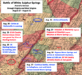
 Battle of White Sulphur Springs Confederate Map.png 477 × 701; 846 KB
-
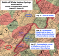
 Battle of White Sulphur Springs Plan.png 918 × 700; 1.63 MB
-
 Battle of White Sulphur Springs Retreat 2.png 842 × 769; 1.21 MB
-
 Battle of White Sulphur Springs Retreat.png 785 × 755; 1.27 MB
-
 Battle of White Sulphur Springs Union Map.png 554 × 786; 709 KB
-
 Battlefield.png 2,066 × 1,464; 3.32 MB
-
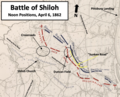
 BattleOfShilohDay1at9am.png 1,049 × 800; 1.35 MB
-
 BattleOfShilohDay1East9AM.png 862 × 795; 1.06 MB
-
 BattleOfShilohDay1noon.png 762 × 616; 767 KB
-
 BattleOfShilohDay1priorto4pm.png 804 × 654; 836 KB
-
 BattleOfShilohDay1West9AM.png 794 × 657; 816 KB
-
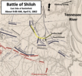
 BattleOfShilohEndOfFirstDay.png 857 × 786; 835 KB
-
 BattleOfShilohEndOfSecondDay.png 830 × 777; 1.06 MB
-
 Blome map, 1775, showing location of Whitechapel Mount.png 1,565 × 1,201; 3.87 MB
-
 Bolivar on the Old Wire Road.png 522 × 784; 656 KB
-
 Britannia Lock, Limehouse Cut, London in 1894.png 1,984 × 1,381; 5.06 MB
-
 Bukan map 1945(1324) russian.jpg 904 × 698; 979 KB
-
 Carte Mouriez Cassin.jpg 3,563 × 2,821; 5 MB
-
 Chambersburg - Hancock - Hagerstown.png 1,244 × 497; 974 KB
-
 Chambersburg - Moorefield Big Picture.png 1,128 × 672; 1.69 MB
-
 Chrausa 02.png 1,003 × 791; 2.03 MB
-
 Christopher Wren's survey of Westheath, 1673.png 1,516 × 1,228; 3 MB
-
 Civitates orbis terrarvm. LOC 2008627031-36 (detail1).jpg 2,951 × 1,268; 1.31 MB


.jpg)
.jpg)


_%D0%BD%D0%B0_%D0%BA%D0%B0%D1%80%D1%82%D1%96_%D0%91%D0%BE%D0%BF%D0%BB%D0%B0%D0%BD%D0%B0_1648_%D1%80%D0%BE%D0%BA%D1%83.jpg)


.jpg)


._Fragment1.jpg)


.png)


.jpg)
.jpg)
_01.jpg)
.jpg)


.jpg)

_(%D0%B8%D1%81%D1%82%D0%BE%D1%87%D0%BD%D0%B8_%D0%BB%D0%B8%D1%81%D1%82)..jpg)


_1860_Porta_Vercellina.jpg)


bukan.jpg)


.png)


_showing_the_location_of_Whitechapel_Mount.png)


_russian.jpg)


.jpg)