Category:Donkere Gaard 4, Oudewater
Jump to navigation
Jump to search
| Object location | | View all coordinates using: OpenStreetMap |
|---|
 | |||||
| Upload media | |||||
| Instance of |
| ||||
|---|---|---|---|---|---|
| Location | Oudewater, South Holland, Netherlands | ||||
| Street address |
| ||||
| Located on street |
| ||||
| Heritage designation |
| ||||
 | |||||
|
This is a category about rijksmonument number 32004
|
| Address |
|
Media in category "Donkere Gaard 4, Oudewater"
The following 26 files are in this category, out of 26 total.
-
 3421 Oudewater, Netherlands - panoramio (11).jpg 2,048 × 1,148; 757 KB
-
 3421 Oudewater, Netherlands - panoramio (99).jpg 4,896 × 3,264; 2.69 MB
-
 Exterieur OVERZICHT MARKTSTRAAT - Oudewater - 20277471 - RCE.jpg 1,189 × 1,200; 367 KB
-
 Interieur - Oudewater - 20376461 - RCE.jpg 1,181 × 1,200; 218 KB
-
 Interieur, console met afbeelding engelenhoofdje - Oudewater - 20376463 - RCE.jpg 1,195 × 1,200; 172 KB
-
 Interieur, console met afbeelding engelenhoofdje - Oudewater - 20376464 - RCE.jpg 1,197 × 1,200; 156 KB
-
 Interieur, console met afbeelding man - Oudewater - 20376465 - RCE.jpg 1,200 × 1,200; 162 KB
-
 Interieur, console met afbeelding man - Oudewater - 20376466 - RCE.jpg 1,192 × 1,200; 157 KB
-
 Interieur, glas-in-lood - Oudewater - 20376462 - RCE.jpg 1,200 × 1,200; 227 KB
-
 Oude nrs.C.65 en B.6gevel - Oudewater - 20179785 - RCE.jpg 890 × 1,200; 224 KB
-
 Oude nrs.C.65 en B.6gevel - Oudewater - 20179787 - RCE.jpg 881 × 1,200; 253 KB
-
 Oude nrs.C.65 en B.6gevel - Oudewater - 20179788 - RCE.jpg 882 × 1,200; 219 KB
-
 Overzicht - Oudewater - 20179797 - RCE.jpg 1,200 × 960; 195 KB
-
 Overzicht - Oudewater - 20179798 - RCE.jpg 1,200 × 960; 201 KB
-
 Overzicht van de voorgevels met trapgevels - Oudewater - 20383995 - RCE.jpg 1,200 × 1,182; 377 KB
-
 Pakhuis - Oudewater - 20179803 - RCE.jpg 884 × 1,200; 250 KB
-
 Pui - Oudewater - 20179804 - RCE.jpg 1,200 × 881; 196 KB
-
 RM32003 Oudewater - Donkere Gaard 3.jpg 1,944 × 2,592; 1.27 MB
-
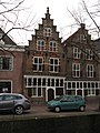
 RM32004 Oudewater - Donkere Gaard 4.jpg 1,944 × 2,592; 1.32 MB
-
 Voorgevel - Oudewater - 20179786 - RCE.jpg 1,200 × 871; 254 KB
-
 Voorgevel - Oudewater - 20179829 - RCE.jpg 888 × 1,200; 298 KB
-
 Voorgevel van voormalig kaaspakhuis - Oudewater - 20179827 - RCE.jpg 884 × 1,200; 265 KB
-
 Voorgevels - Oudewater - 20179799 - RCE.jpg 964 × 1,200; 267 KB
-
 Voorgevels - Oudewater - 20179800 - RCE.jpg 820 × 1,200; 207 KB
-

-
 Voorgevels in straat - Oudewater - 20398841 - RCE.jpg 1,191 × 1,200; 362 KB
.jpg)
.jpg)


