Category:Early Cycladic settlement Panormos on Naxos
Jump to navigation
Jump to search
| Object location | | View all coordinates using: OpenStreetMap |
|---|
archaeological site in Greece | |||||
| Upload media | |||||
| Instance of | |||||
|---|---|---|---|---|---|
| Location |
| ||||
 | |||||
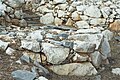
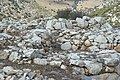
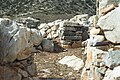
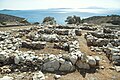
More precisely: Early Cycladic settlement "Korfari ton Amygdalon" (Hill of almonds) near Panormos bay in the southeast of Naxos. (On the southwest coast of Naxos.) The peak experienced at the time of 2800 to 2300 BC (EC II), circa 2000 BC (EC III) was fortified and then disappeared.
Subcategories
This category has only the following subcategory.
F
Media in category "Early Cycladic settlement Panormos on Naxos"
The following 32 files are in this category, out of 32 total.
-
 Early Cycladic Panormos Naxos stairs 119559.jpg 3,471 × 2,311; 6.1 MB
-
 Early Cycladic Panormos Naxos stairs 119562.jpg 3,471 × 2,311; 6.38 MB
-
 Early Cycladic Panormos Naxos stairs 119569.jpg 3,471 × 2,311; 5.11 MB
-
 Early Cycladic settlement Korfari ton Amygdalo Panormos Naxos 000358.jpg 3,471 × 2,311; 4.52 MB
-
 Early Cycladic settlement Korfari ton Amygdalo Panormos Naxos 119564.jpg 3,471 × 2,311; 5.71 MB
-
 Early Cycladic settlement Korfari ton Amygdalon Panormos Naxos 000380.jpg 3,471 × 2,311; 5.8 MB
-
 Early Cycladic settlement Korfari ton Amygdalon Panormos Naxos 119549.jpg 3,471 × 2,311; 7.14 MB
-
 Early Cycladic settlement Korfari ton Amygdalon Panormos Naxos 119563.jpg 3,471 × 2,311; 6.27 MB
-
 Early Cycladic settlement Korfari ton Amygdalon Panormos Naxos 119565.jpg 3,471 × 2,311; 6.94 MB
-
 Early Cycladic settlement Korfari ton Amygdalon Panormos Naxos 119566.jpg 3,471 × 2,311; 7.17 MB
-
 Early Cycladic settlement Korfari ton Amygdalon Panormos Naxos 119567.jpg 3,471 × 2,311; 6.5 MB
-
 Early Cycladic settlement Korfari ton Amygdalon Panormos Naxos 119568.jpg 3,471 × 2,311; 6.34 MB
-
 Early Cycladic settlement Korfari ton Amygdalon Panormos Naxos 119570.jpg 3,471 × 2,311; 5.66 MB
-
 Early Cycladic settlement Korfari ton Amygdalon Panormos Naxos 119572.jpg 3,471 × 2,311; 5.46 MB
-
 Early Cycladic settlement Korfari ton Amygdalon Panormos Naxos 119573.jpg 3,471 × 2,311; 5.15 MB
-
 Early Cycladic settlement Korfari ton Amygdalon Panormos Naxos119575.jpg 3,471 × 2,311; 5.3 MB
-
 Early Cycladic settlement Panormos on Naxos 119576.jpg 3,471 × 2,311; 4.41 MB
-
 Early Cycladic settlement Panormos on Naxos 119577.jpg 3,452 × 2,283; 3.6 MB
-
 Early Cycladic settlement Panormos on Naxos 119578.jpg 3,471 × 2,311; 3.88 MB
-
 Early Cycladic settlement Panormos on Naxos 119580.jpg 3,471 × 2,311; 5.16 MB
-
 Early Cycladic settlement Panormos on Naxos 119581.jpg 3,471 × 2,311; 4.4 MB
-
 Early Cycladic settlement Panormos on Naxos 119582.jpg 3,471 × 2,311; 4.76 MB
-
 Early Cycladic settlement Panormos on Naxos 119584.jpg 3,471 × 2,311; 6.34 MB
-
 Early Cycladic settlement Panormos on Naxos 119585.jpg 3,471 × 2,311; 6 MB
-
 Early Cycladic settlement Panormos on Naxos 119587.jpg 3,471 × 2,311; 6.02 MB
-
 Early Cycladic settlement Panormos on Naxos 119588.jpg 3,471 × 2,311; 6.87 MB
-
 Early Cycladic settlement Panormos on Naxos 119589.jpg 3,471 × 2,311; 6.41 MB
-
 Early Cycladic settlement Panormos on Naxos 119592.jpg 3,471 × 2,311; 6.9 MB
-
 Early Cycladic settlement Panormos on Naxos pottery fragments? 119591.jpg 2,053 × 2,995; 4.16 MB
-
 Kato Mili, view towards Spedos and Panormos on Naxos 144183.jpg 5,047 × 3,365; 9.22 MB
-
 Korfari ton Amygdalon Panormos Naxos monopati 119546.jpg 3,471 × 2,311; 5.49 MB
-
 Panormos 119586.jpg 3,471 × 2,311; 6 MB


