Category:East Pleasanton
Jump to navigation
Jump to search
Collection of photos of the East Pleasanton Specific Plan area.
Media in category "East Pleasanton"
The following 27 files are in this category, out of 27 total.
-
 Arroyo Mocho with Pleasanton Ridge and Hangar One Blimp.jpg 3,264 × 1,836; 1,021 KB
-
 Behind the Pleasanton Garbage Transfer Station.jpg 3,264 × 1,836; 1.24 MB
-
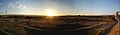
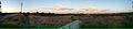
 East Pleasanton Sunset Panorama.jpg 1,396 × 464; 242 KB
-
 Kaiser Sand & Gravel Building and Office.jpg 3,264 × 1,836; 1.38 MB
-
 Kaiser Sand & Gravel Building Crane.jpg 3,264 × 1,836; 1.36 MB
-
 Kaiser Sand & Gravel Building Panorama.jpg 1,020 × 460; 332 KB
-
 Kaiser Sand & Gravel Property Buildings.jpg 3,264 × 1,836; 1.2 MB
-
 Kaiser Sand & Gravel Sunset Panorama.jpg 1,580 × 464; 489 KB
-
 Kiewit Property Buildings.jpg 3,264 × 1,836; 1.67 MB
-
 Kiewit Property Panorama with Pleasanton Garbage Transfer Station.jpg 1,958 × 468; 744 KB
-
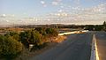
 Looking North on El Charro Rd..jpg 3,264 × 1,836; 1.35 MB
-
 Mt. Diablo from end of Busch Rd..jpg 3,264 × 1,836; 1.38 MB
-
 Paragon Outlets Construction at Dusk.jpg 3,264 × 1,836; 1.08 MB
-
 Pleasanton Garbage Old Gas Pump.jpg 1,836 × 3,264; 1.19 MB
-
 Pleasanton Garbage Service Front-loader.jpg 3,264 × 1,840; 1.49 MB
-
 Pleasanton Garbage Service Trucks.jpg 3,264 × 1,836; 1.63 MB
-
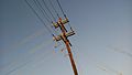 Power Pole Along El Charro Rd..jpg 3,264 × 1,836; 1.13 MB
-
 Southeast Pleasanton Hills in Distance.jpg 3,264 × 1,836; 1.46 MB
-
 Southeast Pleasanton Hills with Kaiser Sand & Gravel Property.jpg 3,264 × 1,836; 1.45 MB
-
 Vehicle Springs.jpg 3,264 × 1,840; 1.32 MB
-
 Zone 7 Building off El Charro Rd..jpg 3,264 × 1,836; 1.27 MB
-
 Zone 7 Lake "H" with Zone 7 Building.jpg 3,264 × 1,836; 1.03 MB
-
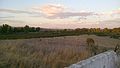
 Zone 7 Lake "I" Panorama.jpg 1,686 × 466; 625 KB
-
 Zone 7 Lake "I" Sunset.jpg 638 × 480; 214 KB
-
 Zone 7 Lake "I" with Pleasanton Ridge.jpg 3,264 × 1,836; 1.41 MB
-
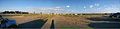
 Zone 7 Property Panorama.jpg 2,066 × 468; 694 KB
-
 Zonen 7 Property with Bushy Peak.jpg 3,264 × 1,836; 1.32 MB


