Category:Ellens Lane bridge
Jump to navigation
Jump to search
| Object location | | View all coordinates using: OpenStreetMap |
|---|
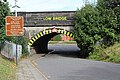
This bridge carries the Wirral Line over Ellens Lane to the north of Port Sunlight railway station. It is designated CRR2/45 on the Hooton Junction to Rock Ferry branch (CRR2) of the Chester & Rock Ferry Line and is 11.89 miles from the datum at Chester.
Media in category "Ellens Lane bridge"
The following 6 files are in this category, out of 6 total.
-
 Bebington - DSC04513.JPG 3,648 × 2,736; 3.57 MB
-
 Benchmark at Ellens Lane bridge, Port Sunlight.jpg 2,946 × 4,662; 8.88 MB
-
 Ellens Lane bridge 1.jpg 5,196 × 3,464; 10.78 MB
-
 Ellens Lane bridge 2.jpg 5,063 × 3,455; 9.94 MB
-
 Ellens Lane bridge 3.jpg 5,322 × 3,176; 6.81 MB
-
 Sewer vent at Ellen's Lane bridge, Port Sunlight.jpg 3,013 × 4,507; 12.88 MB


