Category:English-language maps of Sweden
Jump to navigation
Jump to search
Countries of Europe: Albania · Armenia‡ · Austria · Belgium · Bosnia and Herzegovina · Bulgaria · Croatia · Denmark · Estonia · Finland · France‡ · Germany · Greece · Hungary · Iceland · Italy · Kazakhstan‡ · Latvia · Lithuania · Luxembourg · Moldova · Netherlands‡ · Norway · Poland · Portugal‡ · Romania · Russia‡ · Slovakia · Slovenia · Spain‡ · Sweden · Switzerland · Turkey‡ · Ukraine · United Kingdom
‡: partly located in Europe
‡: partly located in Europe
Media in category "English-language maps of Sweden"
The following 33 files are in this category, out of 33 total.
-
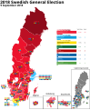 2018 Swedish General Election Map.svg 707 × 858; 568 KB
-
 Koppen-Geiger Map SWE present.svg 1,341 × 850; 4.45 MB
-

-
 Map of Sweden Cities (polar stereographic).svg 1,000 × 2,387; 694 KB
-
 Map of Sweden, CIA, 1996.jpg 2,036 × 2,484; 2.77 MB
-
 Norway and Sweden - DPLA - 28c9a728292de61df1b243054d25161f.jpg 8,396 × 12,562; 6.92 MB
-
 Norway and Sweden - DPLA - 79ef738e26d096867823cef2c15059fb.jpg 8,404 × 12,561; 6.31 MB
-
 Norway and Sweden - DPLA - a0ecf9887c67b0e86d1d0998581fa55e.jpg 8,052 × 11,957; 5.88 MB
-
 Norway and Sweden - DPLA - a13fc6d948ca1bd6f54a7b2fbb5458bd.jpg 8,392 × 12,552; 6.67 MB
-

-
 PAT - Sweden.gif 830 × 1,060; 268 KB
-
 Percentage foreign born and born to two foreign born parents in Sweden.svg 512 × 1,155; 112 KB
-

-
 Sweden - DPLA - 05df6a819caf2878848e7d049cc5a419.jpg 8,575 × 12,621; 9.9 MB
-
 Sweden - DPLA - 0d55f18fec0eccc4844c3d6a6c17119f.jpg 2,556 × 3,278; 6.68 MB
-
 Sweden - DPLA - 644ddb0da9ade26273ad45554f4818d2.jpg 4,304 × 4,691; 1.38 MB
-
 Sweden - DPLA - 71ae8547958e2e7e98bb0deb46793051.jpg 4,304 × 4,704; 1.36 MB
-
 Sweden - DPLA - 8c5e5ed3c2f33b54b57884513d0f3bbb.jpg 4,312 × 4,699; 1.25 MB
-
 Sweden - DPLA - a8ac5ee9bea42889f71d077f2a26e856.jpg 2,314 × 3,650; 8.31 MB
-
 Sweden - DPLA - d00bf86270396119b3e87fe5da9755ba.jpg 2,556 × 3,276; 6.22 MB
-
 Sweden - DPLA - d61b97d1155e50c415c1dfa371034700.jpg 8,056 × 11,960; 6.83 MB
-

-
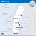 Sweden - Location Map (2013) - SWE - UNOCHA.svg 251 × 251; 1.19 MB
-
 Sweden Administrative Divisions - DPLA - 2de68fbfa6fcc60ed45255a893315a0d.jpg 2,554 × 3,276; 5.82 MB
-
 Sweden Fuel-Charcoal Wood, 1949 - DPLA - c05e658024ae847967fce77ae2551c87.jpg 4,306 × 5,694; 3.12 MB
-
 Sweden Köppen.svg 765 × 1,755; 1.82 MB
-
 Sweden Major Forest Regions - DPLA - 8ec49d96f0fb39c8e9098c70c14eab0b.jpg 4,332 × 5,719; 2.92 MB
-
 Sweden map of Köppen climate classification.svg 1,900 × 1,900; 128 KB
-
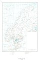
 Sweden travel map1.svg 954 × 1,837; 3.45 MB
-
 Sweden-CIA WFB Map.png 328 × 714; 30 KB
-
 Sweden. 7-63. LOC 75693736.jpg 5,236 × 9,131; 6.99 MB
-
 Sweden. LOC 2011587049.jpg 3,356 × 4,367; 1.98 MB
-
 Sweden. LOC 96686018.jpg 2,496 × 3,281; 825 KB


.svg)


_-_SWE_-_UNOCHA.svg)


