Category:Erehof Texel (Den Burg)
Jump to navigation
Jump to search
| Object location | | View all coordinates using: OpenStreetMap |
|---|
 | |||||
| Upload media | |||||
| Instance of |
| ||||
|---|---|---|---|---|---|
| Location | Den Burg, Texel, North Holland, Netherlands | ||||
 | |||||
Nederlands: Algemene begraafplaats Den Burg en Erehof
|
This is a category about a war memorial in the Netherlands, number: 1019
|
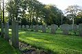
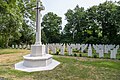
English: Description CWGC: Texel is one of the West Frisian islands and Den Burg is its main town. Follow the signs to Den Helder and then take the ferry to Texel. Coming off the ferry follow the main road towards Den Burg. At the first roundabout turn right, then turn first left into Beatrixlaan. Continue along here and turn left into Kogerstraat which is opposite Boogerd, and the cemetery is at the end of this road. Texel (Den Berg) General Cemetery contains a plot of 167 Commonwealth burials of the Second World War, most of them airmen. 44 of the burials are unidentified.
Nederlands: Oorlogsgraven van het Gemenebest, Erehof Texel (Kogerstraat 57, Den Burg)
Subcategories
This category has the following 2 subcategories, out of 2 total.
Media in category "Erehof Texel (Den Burg)"
The following 14 files are in this category, out of 14 total.
-
 1-Oorlogsgraven van het Gemenebest (den Burg).jpg 4,279 × 2,359; 7.47 MB
-
 2-Erehof Texel, Prieel.jpg 4,320 × 2,181; 5.2 MB
-
 3-Erehof Texel, gedenksteen.jpg 4,272 × 1,876; 5.13 MB
-
 Den Burg - cemetery-70 (cropped).JPG 1,639 × 2,668; 2.06 MB
-
 Den Burg - cemetery-70.JPG 2,592 × 3,888; 5.18 MB
-
 Den Burg, 'De Goede Herder' 2.jpg 4,912 × 3,264; 1.91 MB
-
 Den Burg, 'De Goede Herder' 3.jpg 3,153 × 4,837; 969 KB
-
 Den Burg, 'De Goede Herder' 4.jpg 4,912 × 3,264; 2.04 MB
-
 Kriegsgräber auf dem Friedhof Den Burg (Texel(.jpg 4,200 × 2,800; 10.19 MB
-
 Kriegsopfergedenken - Friedhof Den Burg (Texel).jpg 4,200 × 2,800; 9.68 MB
-
 Texel - Den Burg - begraafplaats -106.jpg 2,592 × 3,888; 6.66 MB
-
 Texel - Den Burg - begraafplaats -49.jpg 3,888 × 2,592; 5.38 MB
-
 Texel - Den Burg - begraafplaats -55.jpg 2,592 × 3,888; 5.37 MB
-
 Texel - Den Burg - begraafplaats -57.jpg 3,888 × 2,592; 5.49 MB
.jpg)


.JPG)


.jpg)


