Category:Evangelische Kirche Zweifall
Jump to navigation
Jump to search
| Object location | | View all coordinates using: OpenStreetMap |
|---|
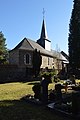
church building in Stolberg, Germany  | |||||
| Upload media | |||||
| Instance of | |||||
|---|---|---|---|---|---|
| Location | Stolberg, Aachen cities region, Cologne Government Region, North Rhine-Westphalia, Germany | ||||
 | |||||
Subcategories
This category has the following 4 subcategories, out of 4 total.
Media in category "Evangelische Kirche Zweifall"
The following 9 files are in this category, out of 9 total.
-
 202102211241a Zweifall Ev Kirche Grabstein.jpg 3,552 × 4,336; 14.21 MB
-
 202102211241b Zweifall Ev Kirche Grabstein.jpg 4,572 × 3,738; 15.95 MB
-
 202102211241c Zweifall Ev Kirche Grabstein.jpg 3,712 × 5,072; 15.41 MB
-
 202102211243b Zweifall Ev Kirche Eingang.jpg 4,000 × 5,856; 20.58 MB
-
 202102211244a Zweifall Ev Kirche + Ex Pastorat.jpg 5,861 × 3,940; 20.83 MB
-
 202102211248b Zweifall Ev Kirche + Friedhof.jpg 4,626 × 3,743; 12.11 MB
-
 202102211254b Zweifall Ev Kirche + Friedhof.jpg 4,000 × 6,016; 18.27 MB
-
 Evangelische Kirche Zweifall 2.JPG 2,160 × 3,840; 3.93 MB
-
 Evangelische Kirche Zweifall.JPG 2,736 × 3,648; 2.9 MB


