Category:Exelby, Leeming and Londonderry
Jump to navigation
Jump to search
civil parish in North Yorkshire, UK  | |||||
| Upload media | |||||
| Instance of | |||||
|---|---|---|---|---|---|
| Location | Hambleton, North Yorkshire, Yorkshire and the Humber, England | ||||
| Population |
| ||||
| Area |
| ||||
 | |||||
English: Exelby, Leeming and Londonderry, formerly Exelby, Leeming and Newton is a civil parish in the Hambleton district of North Yorkshire, England.
Subcategories
This category has the following 3 subcategories, out of 3 total.
E
- Exelby (20 F)
L
- Londonderry, North Yorkshire (10 F)
Media in category "Exelby, Leeming and Londonderry"
The following 59 files are in this category, out of 59 total.
-
 A1(M) heading north - geograph.org.uk - 3091257.jpg 640 × 430; 26 KB
-
 A1(M) near Cowfold Grange Farm - geograph.org.uk - 5825556.jpg 1,024 × 765; 88 KB
-
 A1(M) near Leeming - geograph.org.uk - 3091235.jpg 640 × 430; 26 KB
-
 A1(M) near Londonderry - geograph.org.uk - 5825551.jpg 1,024 × 695; 80 KB
-
 A1(M), heading north - geograph.org.uk - 3091253.jpg 640 × 430; 28 KB
-
 A1(M), northbound - geograph.org.uk - 3091245.jpg 640 × 430; 29 KB
-
 A1(M), northbound - geograph.org.uk - 3091259.jpg 640 × 430; 25 KB
-
 A6055 south west of Leeming - geograph.org.uk - 5722018.jpg 4,307 × 2,633; 2.61 MB
-
 A6055, Londonderry - geograph.org.uk - 5629937.jpg 640 × 371; 35 KB
-
 Approaching Londonderry along Dere Street - geograph.org.uk - 3532600.jpg 1,024 × 683; 149 KB
-
 B6285 outside High Grange Farm - geograph.org.uk - 4874288.jpg 1,600 × 1,067; 625 KB
-
 Bedale Beck from Leeming Bridge - geograph.org.uk - 5974545.jpg 4,299 × 3,005; 3.61 MB
-
 Benchmark on Leeming Bridge - geograph.org.uk - 3532730.jpg 1,024 × 683; 238 KB
-
 Benchmark on Londonderry Lodge - geograph.org.uk - 3532525.jpg 683 × 1,024; 279 KB
-
 Benchmark on wall at Leeming Lodge Farm - geograph.org.uk - 3532662.jpg 683 × 1,024; 303 KB
-
 Bend in the road, Leeming Bridge - geograph.org.uk - 5629899.jpg 640 × 351; 45 KB
-
 Brassica crop, off Westfield Lane - geograph.org.uk - 2254313.jpg 1,024 × 768; 163 KB
-
 Clapham Lodge on Dere Street - geograph.org.uk - 2524571.jpg 800 × 600; 280 KB
-
 Countryside beside the A6055 - geograph.org.uk - 4875484.jpg 1,600 × 1,067; 514 KB
-
 Dere Street - geograph.org.uk - 5629903.jpg 640 × 360; 53 KB
-
 Exelby Methodist Church - geograph.org.uk - 4874296.jpg 1,600 × 1,067; 418 KB
-
 Exelby, Leeming and Londonderry UK parish locator map.svg 1,425 × 1,037; 4.3 MB
-
 Field and Trees - geograph.org.uk - 371618.jpg 640 × 480; 190 KB
-
 Fields alongside Burtree Dyke - geograph.org.uk - 2254308.jpg 1,024 × 768; 191 KB
-
 Green corridor between A1M and A6055 - geograph.org.uk - 3532429.jpg 1,024 × 683; 217 KB
-
 Green Gate - geograph.org.uk - 2254305.jpg 1,024 × 768; 124 KB
-
 Greening field alongside Westfield Lane - geograph.org.uk - 2254311.jpg 1,024 × 768; 113 KB
-
 Greenvale Farm, Dere Street - geograph.org.uk - 3532624.jpg 1,024 × 683; 144 KB
-
 Hedge beside B6285 outside High Grange - geograph.org.uk - 3532453.jpg 1,024 × 683; 207 KB
-
 Houses on Green Gate - geograph.org.uk - 2254306.jpg 1,024 × 768; 174 KB
-
 Leeming Bridge, Leeming Lane - geograph.org.uk - 3532737.jpg 1,024 × 683; 179 KB
-
 Leeming Lodge Farmhouse, Dere Street - geograph.org.uk - 3532670.jpg 1,024 × 683; 206 KB
-
 Leeming Methodist chapel, Leeming - geograph.org.uk - 4723157.jpg 3,072 × 1,728; 1.38 MB
-
 Leeming, Exelby ^ Londonderry Village Hall - geograph.org.uk - 3810872.jpg 3,920 × 2,204; 1.68 MB
-
 Londonderry - The Yorkshire Version - geograph.org.uk - 4874092.jpg 1,600 × 1,067; 321 KB
-
 Londonderry Lodge - geograph.org.uk - 3532593.jpg 1,024 × 683; 146 KB
-
 Londonderry Lodge - geograph.org.uk - 4874111.jpg 1,600 × 1,067; 377 KB
-
 Looking towards Londonderry, Leeming - geograph.org.uk - 2524536.jpg 800 × 600; 228 KB
-
 Low Grange Farm - geograph.org.uk - 4493569.jpg 4,000 × 2,250; 2.09 MB
-
 Mill Farm Leeming - geograph.org.uk - 5970871.jpg 4,014 × 2,909; 2.24 MB
-
 Over the river (and a big fence) - geograph.org.uk - 3811865.jpg 3,920 × 2,204; 1.63 MB
-
 Paddock near Londonderry - geograph.org.uk - 4874306.jpg 1,600 × 1,067; 708 KB
-
 RAF Leeming from the air - geograph.org.uk - 5394967.jpg 640 × 480; 144 KB
-
 Road closed, Exelby Lane - geograph.org.uk - 2254310.jpg 1,024 × 768; 85 KB
-
 Roadworks on the A1 - geograph.org.uk - 2254303.jpg 1,024 × 768; 125 KB
-
 Roman Road beside Leeming Airfield - geograph.org.uk - 5629901.jpg 640 × 360; 56 KB
-
 Sluice Gate, Mill Farm - geograph.org.uk - 3810863.jpg 3,920 × 2,204; 2.1 MB
-
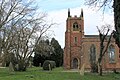 St. John the Baptist Church, Leeming - geograph.org.uk - 4874327.jpg 1,600 × 1,067; 773 KB
-
 Sustrans Bridleway under new A1(M) - geograph.org.uk - 3810832.jpg 3,920 × 2,204; 1.95 MB
-
 The Bottoms - geograph.org.uk - 3811834.jpg 3,920 × 2,204; 2.89 MB
-
 The Green Dragon, Exelby - geograph.org.uk - 4545625.jpg 2,660 × 4,000; 2.51 MB
-
 The lock that never was - geograph.org.uk - 5970863.jpg 3,240 × 4,319; 4.08 MB
-
 The middle Bromaking Grange - geograph.org.uk - 2254337.jpg 1,024 × 768; 211 KB
-

-
 The Willow Tree, Leeming - geograph.org.uk - 4874318.jpg 1,600 × 981; 338 KB
-
 Towards Bromakin Grange - geograph.org.uk - 5722008.jpg 4,147 × 2,779; 2.42 MB
-
 Upgrading the A1 - geograph.org.uk - 2310055.jpg 3,264 × 2,448; 1.22 MB
-
 Upgrading the A1 - geograph.org.uk - 2310063.jpg 3,264 × 2,448; 1.62 MB
-
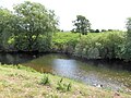 View across the Swale - geograph.org.uk - 5870384.jpg 4,320 × 3,240; 4.63 MB
_heading_north_-_geograph.org.uk_-_3091257.jpg)
_near_Cowfold_Grange_Farm_-_geograph.org.uk_-_5825556.jpg)
_near_Leeming_-_geograph.org.uk_-_3091235.jpg)
_near_Londonderry_-_geograph.org.uk_-_5825551.jpg)
,_heading_north_-_geograph.org.uk_-_3091253.jpg)
,_northbound_-_geograph.org.uk_-_3091245.jpg)
,_northbound_-_geograph.org.uk_-_3091259.jpg)


_-_geograph.org.uk_-_3811865.jpg)


_-_geograph.org.uk_-_3810832.jpg)