Category:Farmhouse, Emmersdorf an der Donau 6
Jump to navigation
Jump to search
| Object location | | View all coordinates using: OpenStreetMap |
|---|
human settlement in Austria  | |||||
| Upload media | |||||
| Instance of | |||||
|---|---|---|---|---|---|
| Part of |
| ||||
| Location | Emmersdorf an der Donau, Melk District, Lower Austria, Austria | ||||
| Street address |
| ||||
| Heritage designation | |||||
 | |||||
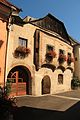
Deutsch: Emmersdorf an der Donau 6, Wohnhaus
Media in category "Farmhouse, Emmersdorf an der Donau 6"
The following 4 files are in this category, out of 4 total.
-
 Emmersdorf 7636.JPG 3,456 × 5,184; 9.65 MB
-
 Emmersdorf 7637.JPG 5,184 × 3,456; 8.95 MB
-
 Emmersdorf Emmersdorf 06 01.jpg 2,496 × 2,488; 3.02 MB
-
 Farmhouse 2.jpg 720 × 396; 83 KB


