Category:Faseny Water
Jump to navigation
Jump to search
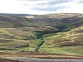
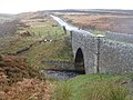
river in Scottish Borders, Scotland, UK, flows into the Whiteadder Reservoir | |||||
| Upload media | |||||
| Instance of | |||||
|---|---|---|---|---|---|
| Location |
| ||||
| Elevation above sea level |
| ||||
| Mouth of the watercourse |
| ||||
 | |||||

Media in category "Faseny Water"
The following 48 files are in this category, out of 48 total.
-
 Faseny Bridge - geograph.org.uk - 1749422.jpg 640 × 359; 92 KB
-
 Faseny Bridge - geograph.org.uk - 1749429.jpg 640 × 480; 119 KB
-
 Faseny Bridge - geograph.org.uk - 1756667.jpg 640 × 359; 89 KB
-
 Faseny Bridge - geograph.org.uk - 3140638.jpg 640 × 480; 102 KB
-
 Faseny Bridge - geograph.org.uk - 3385733.jpg 640 × 360; 174 KB
-
 Faseny Bridge - geograph.org.uk - 3572056.jpg 3,264 × 2,448; 4.69 MB
-
 Faseny Bridge - geograph.org.uk - 3572067.jpg 3,264 × 2,448; 5 MB
-
 Faseny Water - geograph.org.uk - 1627534.jpg 640 × 480; 102 KB
-
 Faseny Water - geograph.org.uk - 1756171.jpg 640 × 359; 100 KB
-
 Faseny Water - geograph.org.uk - 1756659.jpg 640 × 359; 94 KB
-
 Faseny Water - geograph.org.uk - 2959172.jpg 640 × 480; 312 KB
-
 Faseny Water - geograph.org.uk - 2959180.jpg 640 × 480; 341 KB
-
 Faseny Water - geograph.org.uk - 3385390.jpg 640 × 360; 174 KB
-
 Faseny Water - geograph.org.uk - 3603814.jpg 640 × 360; 216 KB
-
 Faseny Water - geograph.org.uk - 4100604.jpg 800 × 450; 375 KB
-
 Faseny Water - geograph.org.uk - 4100606.jpg 640 × 360; 264 KB
-
 Faseny Water - geograph.org.uk - 4101824.jpg 640 × 360; 205 KB
-
 Faseny Water - geograph.org.uk - 4247801.jpg 800 × 600; 404 KB
-
 Faseny Water - geograph.org.uk - 4247807.jpg 800 × 600; 378 KB
-
 Faseny Water - geograph.org.uk - 4247813.jpg 800 × 533; 339 KB
-
 Faseny Water - geograph.org.uk - 4258087.jpg 800 × 600; 394 KB
-
 Faseny Water - geograph.org.uk - 4258088.jpg 800 × 600; 387 KB
-
 Faseny Water - geograph.org.uk - 4751891.jpg 800 × 423; 70 KB
-
 Faseny Water - geograph.org.uk - 841721.jpg 640 × 433; 64 KB
-
 Faseny Water Valley - geograph.org.uk - 3140609.jpg 640 × 480; 90 KB
-

-
 Irish bridge on the Herring Road - geograph.org.uk - 1459547.jpg 640 × 359; 83 KB
-
 Looking down the Faseny Water - geograph.org.uk - 3572072.jpg 3,264 × 2,448; 5.17 MB
-
 Moorland, Duddy Bank - geograph.org.uk - 1075892.jpg 640 × 359; 90 KB
-
 Priestlaw Hill and Faseny Water. - geograph.org.uk - 205777.jpg 640 × 480; 90 KB
-
 Scrub woodland, Faseny Water - geograph.org.uk - 1627533.jpg 640 × 480; 130 KB
-

-

-
 The shades of green and brown - geograph.org.uk - 1043973.jpg 640 × 480; 63 KB
-
 The valley of the Faseny Water - geograph.org.uk - 3571107.jpg 3,264 × 2,448; 4.38 MB
-
 The valley of the Faseny Water - geograph.org.uk - 3572070.jpg 3,264 × 2,448; 5.26 MB
-

-
 Track, Faseny Water - geograph.org.uk - 1496164.jpg 640 × 480; 118 KB
-
 Faseny Bridge - geograph.org.uk - 238668.jpg 640 × 480; 77 KB
-
 Faseny Bridge, Lammermuirs - geograph.org.uk - 75235.jpg 640 × 480; 104 KB
-
 Faseny Water - geograph.org.uk - 121047.jpg 640 × 480; 315 KB
-
 Faseny Water - geograph.org.uk - 236821.jpg 640 × 480; 89 KB
-
 Faseny Water - geograph.org.uk - 238664.jpg 640 × 480; 79 KB
-
 Faseny Water - geograph.org.uk - 326147.jpg 640 × 326; 57 KB
-
 Faseny Water and Penshiel Hill - geograph.org.uk - 205759.jpg 640 × 480; 105 KB
-
 Ford, Faseny Water. - geograph.org.uk - 121038.jpg 640 × 480; 307 KB
-
 Grouse Butt - geograph.org.uk - 205684.jpg 640 × 480; 103 KB
-
 Redstone Rig - geograph.org.uk - 326138.jpg 640 × 480; 101 KB


