Category:Ferme de Montgarny
Jump to navigation
Jump to search
| Object location | | View all coordinates using: OpenStreetMap |
|---|
|
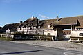
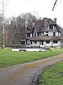
This building is inscrit au titre des monuments historiques de la France. It is indexed in the base Mérimée, a database of architectural heritage maintained by the French Ministry of Culture, under the reference PA02000038
|
human settlement in France .JPG) | |||||
| Upload media | |||||
| Instance of | |||||
|---|---|---|---|---|---|
| Location | Margival, Aisne, Hauts-de-France, Metropolitan France, France | ||||
| Street address |
| ||||
| Heritage designation |
| ||||
 | |||||
Media in category "Ferme de Montgarny"
The following 7 files are in this category, out of 7 total.
-
 Ferme de montgarny (1).JPG 4,000 × 2,672; 3.2 MB
-
 Ferme de montgarny (4).JPG 4,000 × 2,672; 3.21 MB
-
 Ferme de montgarny (5).JPG 4,000 × 2,672; 3.31 MB
-
 Ferme de montgarny (6).JPG 4,000 × 2,672; 2.47 MB
-
 Margival Ferme de Montgarny en 1912.jpg 1,094 × 721; 801 KB
-
 Moulin de la ferme de Montgarny (Aisne).jpg 3,456 × 4,608; 3.28 MB
-
 Moulin de la ferme de Montgarny.jpg 3,456 × 4,608; 2.2 MB
.JPG)
.JPG)
.JPG)

.jpg)
