Category:Flooding in Gloucester
Jump to navigation
Jump to search
Flooding in Gloucester
Media in category "Flooding in Gloucester"
The following 10 files are in this category, out of 10 total.
-
 Beefeater or Moat House^ - geograph.org.uk - 502941.jpg 640 × 482; 93 KB
-
 Gloucester, Llanthony Road - geograph.org.uk - 1091386.jpg 640 × 479; 65 KB
-
 Gloucester, The Quay, Flood Gate - geograph.org.uk - 1081053.jpg 640 × 479; 67 KB
-

-

-
 Parking Bay and Footpath flooding - geograph.org.uk - 502952.jpg 640 × 482; 95 KB
-
 The Quay (A4301) - geograph.org.uk - 502983.jpg 640 × 482; 72 KB
-
 The Quay (A4301) - Sandbags in place - geograph.org.uk - 502989.jpg 640 × 482; 62 KB
-
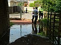 A pensive policeman - geograph.org.uk - 502970.jpg 640 × 482; 110 KB
-
 Footpath under the road bridge at 5-05pm - geograph.org.uk - 503000.jpg 640 × 482; 110 KB


_-_geograph.org.uk_-_502983.jpg)
_-_Sandbags_in_place_-_geograph.org.uk_-_502989.jpg)

