Category:Forte de São Sebastião (Castro Marim)
Jump to navigation
Jump to search
| Object location | | View all coordinates using: OpenStreetMap |
|---|
building in Castro Marim Municipality, Faro District, Portugal  | |||||
| Upload media | |||||
| Instance of | |||||
|---|---|---|---|---|---|
| Location | Castro Marim, Faro, Portugal | ||||
| Heritage designation | |||||
| Different from | |||||
 | |||||
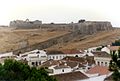
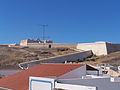
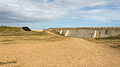
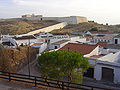
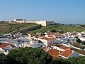
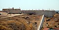
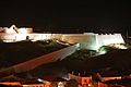
Português: Forte de São Sebastião e partes que restam dos Baluartes e Revelins exteriores que se ligavam ao Castelo. Em Portugal, Faro, Castro Marim, Castro Marim.
|
This monument is classified as
Monumento Nacional .It is indexed in the IGESPAR database ( Instituto de Gestão do Património Arquitectónico e Arqueológico ), under the reference 70936.It is indexed in the SIPA database (Sistema de Informação para o Património Arquitectónico) under the reference 5622. |
Media in category "Forte de São Sebastião (Castro Marim)"
The following 17 files are in this category, out of 17 total.
-
 Castelo de Castro Marim 061.jpg 1,481 × 999; 218 KB
-
 Castro Marim (Portugal) (15671378746).jpg 3,968 × 2,802; 4.97 MB
-
 Castro Marim 100 8288 (3832528437).jpg 2,576 × 1,932; 1.45 MB
-
 Castro Marim 100 8289 (3832529107).jpg 2,576 × 1,932; 1.47 MB
-
 Castro Marim 100 8296 (3833327776).jpg 2,576 × 1,932; 1.55 MB
-
 Castro Marim Castelo R03.jpg 2,262 × 1,687; 3.37 MB
-
 Castro Marim Fort 01.jpg 3,556 × 2,000; 3.84 MB
-
 Castro Marim Fort 02.jpg 3,556 × 2,000; 1.26 MB
-
 Castro Marim Fort 03.jpg 3,556 × 2,000; 1.36 MB
-
 Castro Marim fort.JPG 2,592 × 1,944; 2.2 MB
-
 Castro Marim R02.jpg 2,292 × 1,719; 3.87 MB
-
 Forte de São Sebastião (1).jpg 3,872 × 2,592; 4.1 MB
-
 Forte de São Sebastião (2).jpg 3,872 × 2,592; 4.31 MB
-
 Forte de São Sebastião (3).jpg 3,872 × 2,592; 3.67 MB
-
 Forte de São Sebastião Castro Marim.jpg 3,008 × 1,547; 4.15 MB
-
 Forte de São Sebastião over Castro Marim.jpg 2,000 × 2,238; 4.04 MB
-
 Forte de São Sebastião à noite.jpg 2,996 × 1,998; 703 KB

_(15671378746).jpg)
.jpg)
.jpg)
.jpg)


.jpg)
.jpg)
.jpg)


