Category:Fresh Kills Landfill
Jump to navigation
Jump to search
| Object location | | View all coordinates using: OpenStreetMap |
|---|
landfill site   | |||||
| Upload media | |||||
| Instance of | |||||
|---|---|---|---|---|---|
| Location | Staten Island, New York City, New York | ||||
| Inception |
| ||||
| Dissolved, abolished or demolished date |
| ||||
| Followed by | |||||
 | |||||
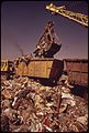
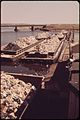
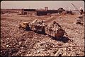
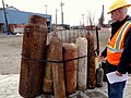
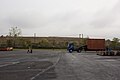
English: The Fresh Kills Landfill is a landfill on the central western edge of Staten Island in New York City. It accepted garbage from April 1948 to March 2001, and was also the site of about one third of the New York City debris from the September 11 attacks. The 2,200-acre (890-hectare) site is being converted into a park over a period of 30 years.
Subcategories
This category has the following 3 subcategories, out of 3 total.
1
- Fresh Kills Landfill in May 1973 (12 F)
2
- Fresh Kills Landfill after 9/11 (21 F)
F
- Freshkills Park (7 F)
Media in category "Fresh Kills Landfill"
The following 24 files are in this category, out of 24 total.
-
-

-
-

-
-

-

-

-

-

-

-
-
-

-
 Wpdms usgs photo fresh kills.jpg 460 × 350; 68 KB
-

-

-
-

-
 December 6, 2012 Fresh Kills Landfill Flyover, Staten Island, New York (8392483666).jpg 5,052 × 3,302; 8.73 MB
-
-
 Fresh Kills West Mound 2023.png 4,032 × 3,024; 8.66 MB
-
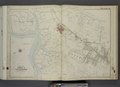
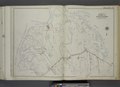
 Sheet No. 51 (Includes Island of Meadows, Fresh Kills and Arthur Kill.) NYPL1531762.tiff 7,230 × 5,428; 112.31 MB
-

_-_Richmond_County_-_Richmond_-_ED_43-1_to_285_-_NARA_-_24519610_(page_5).jpg)


.jpg)
.jpg)
.jpg)
.jpg)
.jpg)
