Category:Frostenden
Jump to navigation
Jump to search
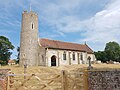
English: Frostenden is a small village in Suffolk, England. Its church, All Saints, is one of 38 existing round-tower churches in Suffolk. It is situated west to the A 12 and can be seen from this major road.
village in the United Kingdom | |||||
| Upload media | |||||
| Instance of | |||||
|---|---|---|---|---|---|
| Location |
| ||||
| Population |
| ||||
 | |||||
Subcategories
This category has the following 3 subcategories, out of 3 total.
Media in category "Frostenden"
The following 138 files are in this category, out of 138 total.
-
 1GL Bolt Frostenden Church - geograph.org.uk - 5744837.jpg 2,410 × 2,410; 2.95 MB
-
 A Claas rubber-track tractor - geograph.org.uk - 2076994.jpg 640 × 521; 108 KB
-

-
 A12 London Road - geograph.org.uk - 2852831.jpg 3,072 × 2,304; 1.32 MB
-
 A12 London Road - geograph.org.uk - 2852846.jpg 3,072 × 2,304; 1.27 MB
-
 A12 London Road, Frosenden - geograph.org.uk - 3522366.jpg 3,072 × 2,304; 1.28 MB
-
 A12 London Road, Frostenden - geograph.org.uk - 3493190.jpg 3,072 × 2,304; 1.36 MB
-
 A12 London Road, Frostenden - geograph.org.uk - 3522352.jpg 3,072 × 2,304; 1.22 MB
-
 A12 towards Lowestoft - geograph.org.uk - 5159297.jpg 640 × 475; 54 KB
-
 A12 towards Lowestoft - geograph.org.uk - 5159514.jpg 640 × 480; 71 KB
-
 All Saints' Church, Frostenden - geograph.org.uk - 5853665.jpg 4,032 × 3,024; 4.67 MB
-
 All Saints' church, rear view - geograph.org.uk - 5853666.jpg 4,032 × 3,024; 3.06 MB
-
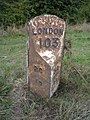
 Bench mark on a milestone (London 103) - geograph.org.uk - 2080415.jpg 640 × 480; 103 KB
-
 Bus Shelter on the A12 London Road - geograph.org.uk - 3522375.jpg 2,304 × 3,072; 1.64 MB
-

-
 Bus Stop on the A12 London Road - geograph.org.uk - 3522376.jpg 2,304 × 3,072; 1.46 MB
-
 Byway to Frostenden Hall - geograph.org.uk - 3864262.jpg 640 × 480; 199 KB
-
 Church Lane ^ footpaths to A12 London Road ^ Clay Common - geograph.org.uk - 3493206.jpg 3,072 × 2,304; 1.65 MB
-
 Church Lane, Frostenden - geograph.org.uk - 3493191.jpg 2,304 × 3,072; 1.32 MB
-
 Church Lane, Frostenden - geograph.org.uk - 3493234.jpg 3,072 × 2,304; 1.44 MB
-
 Church Lane, Frostenden - geograph.org.uk - 3493263.jpg 3,011 × 2,262; 1.41 MB
-
 Clay Common Lane ^ Clay Common Postbox - geograph.org.uk - 3522558.jpg 3,072 × 2,304; 1.39 MB
-
 Clay Common Lane ^ footpath - geograph.org.uk - 3522294.jpg 3,072 × 2,304; 1.34 MB
-
 Clay Common Lane, Clay Common - geograph.org.uk - 3522177.jpg 3,072 × 2,304; 1.31 MB
-
 Clay Common Lane, Clay Common - geograph.org.uk - 3522583.jpg 3,072 × 2,304; 1.47 MB
-
 Clay Common Lane, footpath ^ Low Farm - geograph.org.uk - 3522598.jpg 2,803 × 2,106; 1.17 MB
-
 Clay Common Lane, Frostenden - geograph.org.uk - 3522179.jpg 3,072 × 2,304; 1.48 MB
-
 Clay Common Lane, Frostenden - geograph.org.uk - 3522194.jpg 3,072 × 2,304; 1.46 MB
-
 Clay Common Lane, Frostenden - geograph.org.uk - 3522348.jpg 3,072 × 2,304; 1.25 MB
-
 Clay Common Lane, Frostenden - geograph.org.uk - 3522546.jpg 3,072 × 2,304; 1.57 MB
-
 Clay Common Lane, Uggeshall - geograph.org.uk - 3522613.jpg 3,072 × 2,123; 859 KB
-
 Clay Common Postbox - geograph.org.uk - 3522566.jpg 3,072 × 2,304; 1.6 MB
-
 Clay Common Postbox - geograph.org.uk - 3522570.jpg 2,304 × 3,072; 1.64 MB
-
 Clay Common Postbox - geograph.org.uk - 3522571.jpg 2,304 × 3,072; 1.65 MB
-
 Clay Common Postbox - geograph.org.uk - 3522572.jpg 2,304 × 3,072; 1.64 MB
-
 Clay Common Postbox - geograph.org.uk - 3523503.jpg 2,304 × 3,072; 1.42 MB
-
 Cottage at the four-cross-ways - geograph.org.uk - 2155553.jpg 640 × 480; 134 KB
-
 Country cottage in Frostenden - geograph.org.uk - 2165879.jpg 640 × 480; 290 KB
-

-

-
 Entrance to Frostenden Hall - geograph.org.uk - 3493258.jpg 3,072 × 2,304; 1.62 MB
-
 Farm track on Clay Common - geograph.org.uk - 3864231.jpg 640 × 480; 151 KB
-
 Farmland and woodland, Frostenden - geograph.org.uk - 5159519.jpg 640 × 480; 59 KB
-
 Farmland towards Gough's Wood - geograph.org.uk - 5159293.jpg 640 × 480; 67 KB
-
 Farmland, Frostenden - geograph.org.uk - 5159527.jpg 640 × 480; 54 KB
-
 Field on Clay Common - geograph.org.uk - 3864232.jpg 640 × 480; 162 KB
-
 Fields by Frostenden Hall - geograph.org.uk - 2220835.jpg 640 × 480; 115 KB
-
 Fields by Frostenden Spring - geograph.org.uk - 3864351.jpg 640 × 480; 129 KB
-
 Fields by Primrose Farm - geograph.org.uk - 3864244.jpg 640 × 480; 162 KB
-
 Fields by Primrose Farm - geograph.org.uk - 3864245.jpg 640 × 446; 140 KB
-
 Fields north of Green Lane - geograph.org.uk - 3864257.jpg 640 × 480; 197 KB
-
 Fingerposts on Green Lane - geograph.org.uk - 3864261.jpg 640 × 480; 220 KB
-
 Footpath - geograph.org.uk - 4761513.jpg 768 × 1,024; 298 KB
-
 Footpath across a field of cows - geograph.org.uk - 2155545.jpg 640 × 480; 191 KB
-
 Footpath at Frostenden Corner - geograph.org.uk - 1982112.jpg 640 × 480; 94 KB
-
 Footpath off Clay Common Lane - geograph.org.uk - 3522306.jpg 2,304 × 3,072; 1.67 MB
-
 Footpath off Clay Common Lane - geograph.org.uk - 3522311.jpg 2,304 × 3,072; 1.48 MB
-
 Footpath off Gypsy Lane - geograph.org.uk - 5853646.jpg 4,032 × 3,024; 5.76 MB
-
 Footpath off Kiln Road - geograph.org.uk - 3522218.jpg 2,304 × 3,072; 1.33 MB
-
 Footpath through the woods - geograph.org.uk - 1982135.jpg 640 × 480; 117 KB
-
 Footpath to Clay Common - geograph.org.uk - 3493220.jpg 3,072 × 2,304; 1.41 MB
-
 Footpath to Frostenden Corner - geograph.org.uk - 3491330.jpg 3,072 × 2,304; 1.66 MB
-
 Footpath to the A12 London Road - geograph.org.uk - 3493223.jpg 3,072 × 2,304; 1.36 MB
-
 Footpath to White House Farm ^ Gipsy Lane - geograph.org.uk - 3491290.jpg 3,072 × 2,304; 1.51 MB
-
 Ford at South Cove - geograph.org.uk - 3189365.jpg 3,872 × 2,592; 2.36 MB
-
 Four roads meet - geograph.org.uk - 3391185.jpg 640 × 480; 111 KB
-
 Frostenden Seaport Map.png 1,260 × 924; 272 KB
-
 Frostenden war memorial - geograph.org.uk - 5853668.jpg 2,268 × 3,024; 1.61 MB
-
 Game bird crop by Frostenden Spring - geograph.org.uk - 3864353.jpg 640 × 480; 127 KB
-
 Game bird crop by Frostenden Spring - geograph.org.uk - 3864354.jpg 640 × 416; 142 KB
-
 Gated track into wood by Green Lane - geograph.org.uk - 3864253.jpg 640 × 480; 281 KB
-
 Gipsy Lane sign - geograph.org.uk - 2852819.jpg 3,072 × 2,304; 1.67 MB
-
 Gipsy Lane, Frostenden - geograph.org.uk - 2852816.jpg 2,304 × 3,072; 1.36 MB
-
 Gipsy Lane, Frostenden - geograph.org.uk - 2852851.jpg 3,072 × 2,304; 1.52 MB
-

-
 Green Lane Byway to Frostenden - geograph.org.uk - 3522135.jpg 2,304 × 3,072; 1.32 MB
-
 House at Frostenden Corner, Suffolk - geograph.org.uk - 1982127.jpg 640 × 480; 114 KB
-
 Houses at Frostenden Corner, Suffolk.jpg 640 × 480; 50 KB
-
 Kiln Road with a Suffolk Pink house in the distance - geograph.org.uk - 2880671.jpg 2,448 × 3,264; 2.31 MB
-
 Kiln Road ^ footpath - geograph.org.uk - 3522213.jpg 2,948 × 2,214; 1.23 MB
-
 Kiln Road ^ footpath - geograph.org.uk - 3522275.jpg 3,072 × 2,304; 1.52 MB
-
 Kiln Road, Frostenden - geograph.org.uk - 3522266.jpg 2,304 × 3,072; 1.53 MB
-
 Kiln Road, Frostenden - geograph.org.uk - 3522272.jpg 2,304 × 3,072; 1.25 MB
-
 Lane at Frostenden Corner - geograph.org.uk - 3491307.jpg 2,304 × 3,072; 1.48 MB
-
 London Road (A12), Frostenden - geograph.org.uk - 5159523.jpg 640 × 480; 60 KB
-
 Main Road Postbox - geograph.org.uk - 2852805.jpg 2,304 × 3,072; 1.65 MB
-
 Milestone on the A12 (London 103) - geograph.org.uk - 2080419.jpg 640 × 480; 68 KB
-
 Minor road towards Brampton - geograph.org.uk - 5159511.jpg 640 × 480; 69 KB
-
 Muddy track through Frostenden Spring - geograph.org.uk - 3864350.jpg 640 × 480; 267 KB
-
 Old milepost, Frostenden - geograph.org.uk - 5159296.jpg 480 × 640; 115 KB
-
 Pond by Primrose Farm - geograph.org.uk - 3864246.jpg 640 × 480; 223 KB
-
 Pond by Primrose Farmhouse - geograph.org.uk - 3864240.jpg 640 × 408; 193 KB
-
 Pond in the corner of a field - geograph.org.uk - 3864346.jpg 640 × 480; 254 KB
-
 Postbox at Frostenden Corner - geograph.org.uk - 1982159.jpg 640 × 480; 133 KB
-
 Primrose Lane, Clay Common - geograph.org.uk - 3522585.jpg 3,072 × 2,304; 1.42 MB
-
 Public Conveniences off the A12 London Road - geograph.org.uk - 2852778.jpg 3,072 × 2,304; 1.48 MB
-
 Public footpath to Clay Common - geograph.org.uk - 2220833.jpg 640 × 480; 175 KB
-
 Road Junction - geograph.org.uk - 1660277.jpg 640 × 480; 95 KB
-
 Road leading into Blomfield Wood - geograph.org.uk - 2880664.jpg 3,264 × 2,448; 2.54 MB
-
 Roadsign at Frostenden Corner - geograph.org.uk - 3491313.jpg 2,304 × 3,072; 1.6 MB
-
 Roadsign at Frostenden Corner - geograph.org.uk - 3491319.jpg 2,304 × 3,072; 1.65 MB
-
 Roadsign at Gipsy Lane junction - geograph.org.uk - 3491340.jpg 2,304 × 3,072; 1.62 MB
-
 Roadsigns on the A12 London Road - geograph.org.uk - 2852841.jpg 2,304 × 3,072; 1.25 MB
-
 Roadsigns on the A12 London Road - geograph.org.uk - 3522382.jpg 2,304 × 3,072; 1.49 MB
-
 Shiplap Bungalow at Frostenden - geograph.org.uk - 2165872.jpg 640 × 480; 255 KB
-
 Small pond in field - geograph.org.uk - 3864349.jpg 480 × 640; 218 KB
-
 South Cove - geograph.org.uk - 3491370.jpg 3,072 × 2,304; 1.64 MB
-
 South Cove at Gipsy Lane junction - geograph.org.uk - 3491339.jpg 3,072 × 2,304; 1.52 MB
-
 South Cove ^ footpath - geograph.org.uk - 3491115.jpg 3,072 × 2,304; 1.46 MB
-
 South Cove ^ footpath to Frostenden Corner - geograph.org.uk - 3491323.jpg 3,072 × 2,304; 1.61 MB
-
 Telephone Box ^ Main Road Postbox - geograph.org.uk - 2852798.jpg 3,072 × 2,304; 1.68 MB
-
 Telephone Box ^ Main Road Postbox - geograph.org.uk - 2852802.jpg 2,304 × 3,072; 1.69 MB
-
 The Corner Postbox - geograph.org.uk - 3491300.jpg 3,072 × 2,304; 1.68 MB
-
 The Corner Postbox - geograph.org.uk - 3491302.jpg 2,304 × 3,072; 1.48 MB
-
 The Corner Postbox - geograph.org.uk - 3491305.jpg 2,304 × 3,072; 1.68 MB
-
 The Corner Postbox - geograph.org.uk - 3491314.jpg 2,304 × 3,072; 1.48 MB
-
 The lane to Frostenden Hall - geograph.org.uk - 2220830.jpg 640 × 480; 142 KB
-
 Track - geograph.org.uk - 4650124.jpg 1,024 × 768; 217 KB
-
 Trees in field by Primrose Farm - geograph.org.uk - 3864259.jpg 640 × 568; 173 KB
-
 View along Green Lane - geograph.org.uk - 3864250.jpg 640 × 480; 206 KB
-
 Wash Lane junction - geograph.org.uk - 3522201.jpg 3,072 × 2,001; 1.72 MB
-
 Wash Lane, Frostenden - geograph.org.uk - 3522184.jpg 3,072 × 2,304; 1.55 MB
-
 Wash Lane, Frostenden - geograph.org.uk - 3522186.jpg 2,304 × 3,072; 1.54 MB
-
 Wash Lane, Frostenden - geograph.org.uk - 3522288.jpg 3,072 × 2,304; 1.56 MB
-
 WW1 names of the fallen on the Frostenden war memorial - geograph.org.uk - 5853673.jpg 2,016 × 1,512; 1.32 MB
-
 WW2 names of the fallen on the Frostenden war memorial - geograph.org.uk - 5853674.jpg 2,016 × 1,512; 1.19 MB
-
 Young crop field, Frostenden - geograph.org.uk - 5159300.jpg 640 × 480; 51 KB
-
 Clay Common - geograph.org.uk - 439596.jpg 640 × 480; 85 KB
-
 Copper Covert and Track - geograph.org.uk - 439947.jpg 640 × 480; 74 KB
-
 End of track, footpath only from here - geograph.org.uk - 439921.jpg 640 × 480; 76 KB
-
 Gipsy Lane - geograph.org.uk - 439612.jpg 640 × 480; 93 KB
-
 Gipsy Lane meets the A12 - geograph.org.uk - 439910.jpg 640 × 480; 77 KB
-
 Green Way - geograph.org.uk - 101051.jpg 480 × 640; 107 KB
-
 Large Pond at Clay Common - geograph.org.uk - 439913.jpg 640 × 480; 105 KB
-
 Primrose Lane Junction - geograph.org.uk - 439917.jpg 640 × 480; 82 KB
-
 Road into Blomfield Wood - geograph.org.uk - 440740.jpg 640 × 480; 66 KB
-
 Turnip Field - geograph.org.uk - 101047.jpg 640 × 480; 174 KB
-
 Wash Lane and Brick Kiln Farm - geograph.org.uk - 439914.jpg 640 × 480; 72 KB


_-_geograph.org.uk_-_2080415.jpg)


,_Frostenden_-_geograph.org.uk_-_5159523.jpg)

_-_geograph.org.uk_-_2080419.jpg)


