Category:Gare de Montpon-Ménestérol
Jump to navigation
Jump to search
| Object location | | View all coordinates using: OpenStreetMap |
|---|
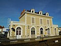
railway station in Montpon-Ménestérol, France  | |||||
| Upload media | |||||
| Instance of | |||||
|---|---|---|---|---|---|
| Location | Montpon-Ménestérol, Dordogne, New Aquitaine, Metropolitan France, France | ||||
| Transport network | |||||
| Owned by | |||||
| Operator | |||||
| Date of official opening |
| ||||
| Elevation above sea level |
| ||||
| Connecting line | |||||
| Adjacent station | |||||
 | |||||
Media in category "Gare de Montpon-Ménestérol"
The following 5 files are in this category, out of 5 total.
-
 Gare de Montpon-Ménestérol (1).jpg 4,608 × 3,456; 3.55 MB
-
 Gare de Montpon-Ménestérol ou « Monpont ».jpg 4,088 × 2,040; 1.78 MB
-
 Montpon-Ménestérol gare voie.JPG 3,264 × 2,448; 3.75 MB
-
 Montpon-Ménestérol gare.JPG 3,264 × 2,448; 3.22 MB
-
 TER Aquitaine, gare de Montpon-Ménestérol.jpg 4,186 × 3,136; 3.08 MB
.jpg)


