Category:Geroldsgrün
Vai alla navigazione
Vai alla ricerca
municipality of Germany     | |||||
| Carica un file multimediale | |||||
| Istanza di |
| ||||
|---|---|---|---|---|---|
| Parte di |
| ||||
| Luogo | circondario di Hof, Alta Franconia, Baviera, Germania | ||||
| Capo del governo |
| ||||
| Popolazione |
| ||||
| Superficie |
| ||||
| Altezza sul mare |
| ||||
| sito web ufficiale | |||||
 | |||||
Sottocategorie
Questa categoria contiene le 9 sottocategorie indicate di seguito, su un totale di 9.
File nella categoria "Geroldsgrün"
Questa categoria contiene 12 file, indicati di seguito, su un totale di 12.
-
 Wappen Geroldsgrün.png 150 × 160; 8 KB
-
 Wappen von Geroldsgrün.svg 646 × 754; 764 KB
-
 Blick vom Brendelfelsen auf Neuenhammer, Untersteinbach bei Geroldsgrün (MGK01366).jpg 5 184 × 3 456; 10,07 MB
-
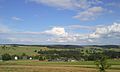 Blick vom Veiteknock nach Osten.jpg 2 560 × 1 536; 1,09 MB
-
 Digitales Orthofoto von Geroldsgrün (Bayerische Vermessungsverwaltung).tif 20 000 × 22 500; 1,26 GB
-
 Geroldsgrün im Landkreis Hof.png 613 × 489; 96 KB
-
 Geroldsgrün in HO.svg 642 × 501; 1,27 MB
-
 Geroldsgrün, HO - Geroldsreuth v NO, Geroldsgrün v O.jpg 4 608 × 2 592; 795 KB
-
 Heinrichs Ruh.jpg 1 536 × 2 048; 895 KB
-
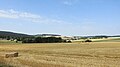
 Langenbach (Frankenwald).JPG 2 048 × 1 536; 700 KB
-
 Ortsschild Dürrenwaiderhammer.jpg 1 552 × 2 592; 690 KB
-
 Ortsschild Untersteinbach.jpg 1 536 × 2 048; 639 KB

.jpg)


.JPG)

