Category:Gevers Deynootplein
Jump to navigation
Jump to search
| Object location | | View all coordinates using: OpenStreetMap |
|---|
Nederlands: Afbeeldingen van het Gevers Deynootplein in Scheveningen in de gemeente Den Haag in de provincie Zuid-Holland in het westen van Nederland. Onder meer bereikbaar vanaf de straat de Gevers Deynootweg
square in Scheveningen (The Hague), the Netherlands  | |||||
| Upload media | |||||
| Instance of | |||||
|---|---|---|---|---|---|
| Named after | |||||
| Location | The Hague, South Holland, Netherlands | ||||
 | |||||
Nederlands: Gevers Deynootplein, Scheveningen, Den Haag, Den Haag (gemeente), Zuid-Holland, Nederland
Subcategories
This category has the following 3 subcategories, out of 3 total.
K
Media in category "Gevers Deynootplein"
The following 18 files are in this category, out of 18 total.
-
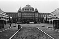
 Den haag Kurhaus Hotel.JPG 3,264 × 2,448; 1.4 MB
-
 Den Haag Scheveningen Kurhaus 12.jpg 4,484 × 2,845; 4.78 MB
-
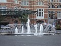 Fontein - panoramio.jpg 4,000 × 3,000; 4.33 MB
-

-

-

-
-
-
 KITLV A1044 - Leo Hageraats op het Gevers Deynootplein te Scheveningen, KITLV 116746.tiff 1,813 × 1,402; 7.29 MB
-
 Kurhaus Hotel in stadsdeel Scheveningen, 's-Gravenhage Augustus 2016 B.jpg 3,072 × 1,728; 1.57 MB
-
 Kurhaus Scheveningen P1290153.jpg 4,144 × 1,920; 4.99 MB
-
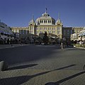
 Overzicht - Scheveningen - 20196204 - RCE.jpg 1,200 × 952; 163 KB
-
 Overzicht - Scheveningen - 20196205 - RCE.jpg 1,200 × 947; 201 KB
-
 Overzicht met Kurhaus - Scheveningen - 20196201 - RCE.jpg 1,200 × 957; 191 KB
-

-
 Overzicht voorzijde vanaf de boulevard gezien - Scheveningen - 20396182 - RCE.jpg 1,200 × 1,200; 226 KB
-
 Scheveningen Kurhaus achterkant.JPG 3,264 × 2,448; 3.43 MB
-


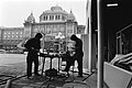
_in_Scheveningen,_twee_werklui_aan_het_werk_bij_het_plein,_Bestanddeelnr_931-4120.jpg)
_in_Scheveningen,_vernieuwde_plein_in_Scheveningen,_Bestanddeelnr_931-4119.jpg)


