Category:Grabmayrstraße 10 (Meran)
Jump to navigation
Jump to search
| Object location | | View all coordinates using: OpenStreetMap |
|---|
| This category shows the cultural heritage monument with the number 15924 in South Tyrol. (Wikidata)
|
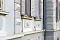
Deutsch: Grabmayrstraße 10 in Meran
 | |||||
| Upload media | |||||
| Instance of | |||||
|---|---|---|---|---|---|
| Location | Merano, South Tyrol, Trentino-South Tyrol, Italy | ||||
| Heritage designation | |||||
 | |||||
Media in category "Grabmayrstraße 10 (Meran)"
The following 6 files are in this category, out of 6 total.
-
 Grabmayrstraße 10, Mais, Meran (Nord).JPG 5,184 × 3,456; 9.75 MB
-
 Grabmayrstraße 10, Mais, Meran (Ost)(2).JPG 3,456 × 2,304; 1.09 MB
-
 Grabmayrstraße 10, Mais, Meran (Ost).JPG 5,184 × 3,456; 7.97 MB
-
 Meran Grabmayerstr. 10.jpg 3,391 × 2,523; 5.97 MB
-
 Meran Grabmayrstraße 10 Details.jpg 5,154 × 3,438; 4.31 MB
-
 Merano Karl-Grabmayrstraße 10.jpg 4,008 × 6,008; 20.73 MB
.JPG)
(2).JPG)
.JPG)

