Category:Green Lane, Eastham
Jump to navigation
Jump to search
| Object location | | View all coordinates using: OpenStreetMap |
|---|

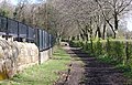
Green Lane is a public bridleway designated BR32 running roughly east from the A41 New Chester Road near Christ the King church, Bromborough, into Eastham Country Park and towards Eastham Ferry.
Subcategories
This category has the following 2 subcategories, out of 2 total.
Media in category "Green Lane, Eastham"
The following 8 files are in this category, out of 8 total.
-
 Green Lane, Eastham 1a.jpg 5,085 × 3,389; 29.81 MB
-
 Green Lane, Eastham 2.jpg 5,049 × 3,246; 21.55 MB
-
 Green Lane, Eastham 3a.jpg 5,170 × 3,458; 25.1 MB
-
 Green Lane, Eastham 3b.jpg 5,133 × 3,406; 23.06 MB
-
 Green Lane, Eastham 4a.jpg 5,198 × 3,462; 25.5 MB
-
 Green Lane, Eastham 4b.jpg 5,083 × 3,387; 23.47 MB
-
 Path to Green Lane, Eastham Country Park (geograph 4563598).jpg 1,024 × 683; 341 KB
-
 Public Footpath and Bridleway, Green Lane.JPG 3,648 × 2,736; 3.58 MB


.jpg)
