Category:Gruberhorn
Jump to navigation
Jump to search
mountain in the Salzkammergut-Berge in Salzburg  | |||||
| Upload media | |||||
| Instance of | |||||
|---|---|---|---|---|---|
| Location | |||||
| Mountain range | |||||
| Topographic isolation |
| ||||
| Elevation above sea level |
| ||||
 | |||||
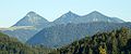
Deutsch: Das Gruberhorn ist ein 1732 m hoher Berg der Osterhorngruppe im Land Salzburg. Sein Gipfel befindet sich am Schnittpunkt der Gemeindegrenzen von Sankt Koloman, Abtenau und Hintersee.
Media in category "Gruberhorn"
The following 6 files are in this category, out of 6 total.
-
 Gruberhorn vom Gennerhorn aus betrachtet.jpg 2,448 × 3,264; 3.77 MB
-
 OsterhorngruppeFromFaistenauGennerGruberhornRegenspitz.jpg 1,000 × 414; 86 KB
-
 OsterhorngruppeGruberhornFromN.jpg 1,000 × 665; 216 KB
-
 OsterhorngruppeGruberhornFromW.jpg 665 × 1,000; 233 KB
-
 OsterhorngruppeGruberhornRegenspitzFromGennerhorn.jpg 1,000 × 665; 192 KB
-
 Sankt koloman.jpg 3,810 × 2,140; 5.94 MB


