Category:Gurgler Kamm
Jump to navigation
Jump to search
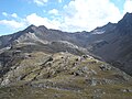
Deutsch: Der Gurgler Kamm (auch Gurglkamm) ist ein Gebirgskamm im Süden der Ötztaler Alpen und bildet zwischen Hoher Wilde und Timmelsjoch die Grenze zwischen Österreich und Italien. Höchste Gipfel: Hohe Wilde (3.480 m), Hintere Seelenkogel (3.470 m ü. A.), Hochfirst (3.403 m) und Liebener Spitze (3.399 m).
Français : Le Gurgler Kamm est une chaîne de montagne su sud des alpes de l'Ötztal. Elle forme la frontière entre l'Autriche et l'Italie. Les sommets remarquables sont Hohe Wilde (3.480 m), Hintere Seelenkogel (3.470 m ü. A.), Hochfirst (3.403 m) und Liebener Spitze (3.399 m).
mountain range of the Ötztal Alps along the border Tyrol / South Tyrol  | |||||
| Upload media | |||||
| Instance of |
| ||||
|---|---|---|---|---|---|
| Part of | |||||
| Location |
| ||||
| Mountain range | |||||
 | |||||
Subcategories
This category has the following 3 subcategories, out of 3 total.
G
H
- Hochwilde (1 P, 44 F)
Media in category "Gurgler Kamm"
The following 11 files are in this category, out of 11 total.
-
 2008 Ötztal 232 Nedersee.jpg 2,048 × 1,536; 1.39 MB
-
 2014-10-24 07-45-55 Austria Tirol Zellberg Hochfügen.jpg 4,288 × 2,848; 7 MB
-
 DS DSC 0065 2011.JPG 4,288 × 2,848; 3.69 MB
-
 Gaisbergferner gletscher ötztal.jpg 1,200 × 900; 639 KB
-
 Hohe Mut 10083 Rotmoosferner.jpg 2,043 × 1,161; 1.78 MB
-
 Hohe Mut 10088 Gaisbergferner.jpg 1,600 × 968; 1.61 MB
-
 Hohe Mut 10104 Hochfirst.jpg 1,280 × 960; 564 KB
-
 Hohe Mut 10108 Liebenerspitze.jpg 2,560 × 1,316; 891 KB
-
 Liebenerspitze, Hochfirst E.JPG 3,404 × 1,308; 3.57 MB
-
 Timmelsjoch Total.jpg 2,592 × 1,944; 2.17 MB
-
 Vorderer Seelenkogel, Mittlerer Seelenkogel and Eiskögele (12813202525).jpg 5,184 × 3,456; 8.79 MB


.jpg)