Category:Gutshof Sittendorf 17, Grafenegg
Jump to navigation
Jump to search
| Object location | | View all coordinates using: OpenStreetMap |
|---|
 | |||||
| Upload media | |||||
| Instance of | |||||
|---|---|---|---|---|---|
| Location | Grafenegg, Krems District, Lower Austria, Austria | ||||
| Street address |
| ||||
| Heritage designation | |||||
 | |||||
Deutsch: Der herrschaftliche Gutshof/Meierhof trägt sowohl die Hausnummer 16 als auch 17. Der Bau stammt aus dem 18. Jahrhundert.
Media in category "Gutshof Sittendorf 17, Grafenegg"
The following 3 files are in this category, out of 3 total.
-
 Sittendorf 16 - Garagentor des Gutshofs mit verschiedenen Hausnummern.jpg 5,195 × 3,463; 6.83 MB
-
 Sittendorf 16 - herrschaftlicher Gutshof.jpg 4,740 × 3,160; 5.07 MB
-
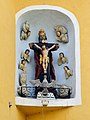 Sittendorf 16 - Skulpturengruppe hl Dreifaltigkeit.jpg 2,554 × 3,406; 5.29 MB

