Category:Heilig Hartkerk (Lier)
Jump to navigation
Jump to search
| Object location | | View all coordinates using: OpenStreetMap |
|---|
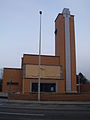
church in Lier, Belgium  | |||||
| Upload media | |||||
| Instance of | |||||
|---|---|---|---|---|---|
| Dedicated to | |||||
| Location | Lier, Arrondissement of Mechelen, Province of Antwerp, Flemish Region, Belgium | ||||
| Diocese | |||||
| Architect | |||||
| Heritage designation | |||||
 | |||||
|
This is a category about onroerend erfgoed number 10062
|
|
This is a category about Beschermd erfgoed number 4664
|
Subcategories
This category has the following 2 subcategories, out of 2 total.
Media in category "Heilig Hartkerk (Lier)"
The following 10 files are in this category, out of 10 total.
-
Heilig Hartkerk Lier klok.ogg 1 min 25 s; 1.64 MB
-
 Heilig Hartkerk 1.jpg 4,000 × 6,000; 7.42 MB
-
 Heilig Hartkerk 2.jpg 2,800 × 4,048; 4.12 MB
-
 Heilig Hartkerk achterzijde.jpg 6,000 × 4,000; 7.03 MB
-
 Heilig Hartkerk Goede Herder.jpg 6,000 × 4,000; 6.88 MB
-
 Heilig Hartkerk Lier.JPG 1,704 × 2,272; 862 KB
-
 Heilig Hartkerk plaat.jpg 800 × 1,200; 433 KB
-
 Heilig Hartkerk Toren west.jpg 4,000 × 6,000; 7.27 MB
-
 Heilig Hartkerk toren zuid.jpg 4,000 × 6,000; 6.05 MB
-
Kerkklokken begrafenis.ogg 26 s; 414 KB


