Category:Helgeladt in annis Christi 800, 1300 & 1649
Jump to navigation
Jump to search
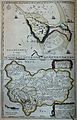
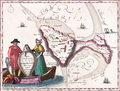
English: In the 17th century, it was purported among historians that Heligoland had been much larger in ancient times, and maps showing that former size were produced. The most widely circulated of these fabrications showed outlines of a supposed Heligoland in 800 and 1300 AD, as well as the shoals and actual shape of Heligoland in 1649.
Media in category "Helgeladt in annis Christi 800, 1300 & 1649"
The following 12 files are in this category, out of 12 total.
-
-
 Helgoland 1649.jpg 2,896 × 2,188; 1.83 MB
-
 DECKEN(1826) p267 Karten von. Helgoland im Mittelalter.jpg 2,873 × 4,171; 5.09 MB
-
 ETH-BIB-Helgoland, in annis Christi 800, 1300, 1619 (Schwindel!)-Dia 247-Z-00282.tif 3,620 × 2,848; 9.97 MB
-
 Helgoland 1651.jpg 3,049 × 4,604; 16.05 MB
-
 Helgoland 1652.jpg 945 × 696; 519 KB
-

-
 JBAM 069.JPG 2,592 × 1,950; 3.1 MB
-
 Karta. PBhist.287 36 - Skoklosters slott - 90127 (cropped - top).png 3,342 × 2,534; 14.5 MB
-
 Karta. PBhist.287 36 - Skoklosters slott - 90127.png 3,574 × 5,476; 34.17 MB
-
 Karta. PBhist.287:36 - Skoklosters slott - 90127.tif 3,574 × 5,476; 56.05 MB
-
 Travels in various countries of Europe, Asia and Africa (1810) (14781577332).jpg 1,500 × 1,105; 266 KB
.jpg)

_p267_Karten_von._Helgoland_im_Mittelalter.jpg)


_(With_plates,_including_a_portrait.)%27_(11001742315).jpg)

.png)

_(14781577332).jpg)