Category:Herrenhaus mit Kapelle St. Peter und Paul und Speicher (Maggenberg, Tafers)
Jump to navigation
Jump to search
| Object location | | View all coordinates using: OpenStreetMap |
|---|
 | |||||
| Upload media | |||||
| Instance of | |||||
|---|---|---|---|---|---|
| Location |
| ||||
| Heritage designation |
| ||||
 | |||||
Media in category "Herrenhaus mit Kapelle St. Peter und Paul und Speicher (Maggenberg, Tafers)"
The following 12 files are in this category, out of 12 total.
-
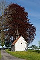 B-Tafers-Maggenberg-Kapelle-St-Peter-und-Paul.jpg 800 × 1,200; 1.41 MB
-
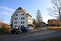
 Schloss Maggenberg 01.jpg 4,192 × 2,808; 2.46 MB
-
 Schloss Maggenberg 02.jpg 4,620 × 2,984; 2.37 MB
-
 Schloss Maggenberg 03.jpg 2,920 × 3,896; 1.93 MB
-
 Schloss Maggenberg 04.jpg 4,752 × 3,168; 4.06 MB
-
 Schloss Maggenberg 05.jpg 4,752 × 3,168; 2.76 MB
-
 Schloss Maggenberg 06 Kapelle.jpg 2,392 × 3,344; 1.96 MB
-
 Schloss Maggenberg 07 Kapelle.jpg 4,752 × 3,168; 2.96 MB
-
 Schloss Maggenberg 08 Kapelle.jpg 3,972 × 2,220; 5.02 MB
-
 Schloss Maggenberg 09 Kapelle.jpg 4,752 × 3,168; 2.17 MB
-
 Schloss Maggenberg 11 Baumbestand.jpg 4,752 × 3,168; 2.64 MB
-
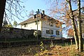 Schloss Maggenberg 12 Gärtnerhaus.JPG 4,752 × 3,168; 4.06 MB


