Category:Herrnbrunnen (Rothenburg ob der Tauber)
Jump to navigation
Jump to search
| Object location | | View all coordinates using: OpenStreetMap |
|---|
 | |||||
| Upload media | |||||
| Instance of | |||||
|---|---|---|---|---|---|
| Location | Rothenburg ob der Tauber, Ansbach, Middle Franconia, Bavaria, Germany | ||||
| Street address |
| ||||
| Heritage designation | |||||
 | |||||
This is the category of the Bavarian Baudenkmal (cultural heritage monument) with the ID D-5-71-193-196 (Wikidata)
|
Subcategories
This category has only the following subcategory.
Media in category "Herrnbrunnen (Rothenburg ob der Tauber)"
The following 40 files are in this category, out of 40 total.
-
 Alt-Nürnberg und das malerische Frankenland (1912) 051.jpg 2,062 × 2,762; 3.11 MB
-
 Brunnen in Rothenburg ob der Tauber 6802.jpg 2,048 × 1,536; 1.55 MB
-
 Fontän på torg i Rothenburg - TEK - TEKA0115237.tif 3,508 × 3,543; 23.73 MB
-
 Fountain IMG 6988 - Rothenburg ob der Tauber.JPG 2,255 × 3,233; 2.38 MB
-
 GER Rothenburg ob der Tauber, Herrngasse 003.jpg 4,032 × 3,024; 2.24 MB
-
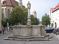
 Herrnbrunnen - panoramio.jpg 5,184 × 3,456; 7.54 MB
-
 Herrnbrunnen - Rothenburg ob der Tauber - Germany 2017.jpg 5,184 × 3,456; 11.64 MB
-
 Herrnbrunnen i Rothenburg - TEK - TEKA0117663.tif 2,466 × 3,543; 16.7 MB
-
 Herrnbrunnen, Rothenburg ob der Tauber, 1901.jpg 1,288 × 1,300; 335 KB
-
 Herrnbrunnen, Rothenburg ob der Tauber, 1910.jpg 906 × 1,300; 222 KB
-
 Herrnbrunnen, Rothenburg ob der Tauber.JPG 4,608 × 3,456; 3.91 MB
-
 Herrngasse, Herrnbrunnen Rothenburg ob der Tauber 20180922 001.jpg 6,016 × 4,016; 11.14 MB
-
 Herrngasse, Herrnbrunnen Rothenburg ob der Tauber 20230122 0067.jpg 5,775 × 4,023; 22.75 MB
-
 Herrngasse.jpg 4,288 × 2,848; 5.94 MB
-
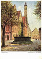
 Historische Ansichtskarte mit Motiv von Rothenburg 15.jpg 408 × 572; 266 KB
-
 Historische Ansichtskarte mit Rothenburger Motiv 07.jpg 402 × 563; 218 KB
-
 Illuminated Herrnbrunnen (Rothenburg ob der Tauber) 2021.jpg 4,032 × 2,268; 2.04 MB
-
 People at rest.jpg 3,480 × 2,652; 5.24 MB
-
 Rotenburg (27).jpg 3,264 × 4,912; 8.68 MB
-
 Rothenburg BW 6.JPG 3,443 × 2,286; 2.56 MB
-
 Rothenburg Herrnbrunnen Schandkorb1.JPG 3,264 × 4,252; 3.02 MB
-
 Rothenburg Herrnbrunnen Schandkorb2.JPG 4,928 × 3,264; 9 MB
-
 Rothenburg o.d.T. - panoramio (2).jpg 2,048 × 1,536; 583 KB
-
 Rothenburg ob der Tauber - Herrnbrunnen - 20040711.jpg 3,264 × 2,448; 3.49 MB
-
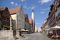
 Rothenburg ob der Tauber Herrngasse 001.JPG 3,444 × 2,496; 2.28 MB
-
 Rothenburg ob der Tauber Herrngasse Herrenbrunne-001.jpg 3,264 × 4,928; 5.97 MB
-
 Rothenburg ob der Tauber Herrngasse Herrenbrunne-002.jpg 3,264 × 4,928; 7.12 MB
-
 Rothenburg ob der Tauber May 2022 KW 22.jpg 3,643 × 2,732; 8.37 MB
-
 Rothenburg ob der Tauber, Brunnen in der Herrngasse, vom Rathausturm 20170526 001.jpg 5,995 × 4,002; 11.05 MB
-
 Rothenburg ob der Tauber, die Herrngasse und der Herrnbrunnen.jpg 4,768 × 3,450; 3.04 MB
-
 Rothenburg ob der Tauber, die Häuser Herrngasse 10 und 12, Herrnbrunnen.jpg 2,946 × 4,748; 4.17 MB
-
 Rothenburg ob der Tauber, Herrngasse, Herrnbrunnen-20121012-001.jpg 4,011 × 6,056; 9.83 MB
-
 Rothenburg ob der Tauber, Herrngasse, Herrnbrunnen-20121012-002.jpg 4,012 × 6,057; 12.46 MB
-
 Rothenburg ob der Tauber, Herrngasse, Herrnbrunnen-20150501-001.jpg 6,057 × 4,012; 12.36 MB
-
 Rothenburg ob der Tauber, Herrngasse, Herrnbrunnen-20150501-002.jpg 4,012 × 6,057; 12.13 MB
-
 Rothenburg ob der Tauber-(Herrnbrunnen-2-Herrngasse 12)-damir-zg.jpg 2,735 × 3,647; 2.88 MB
-
 Rothenburg odT Herrngasse.jpg 900 × 599; 310 KB
-
 Rothenburg, Herrenbrunnen-001.jpg 1,200 × 1,600; 367 KB
-
 Rothenburg, Herrenbrunnen-002.jpg 1,200 × 1,600; 440 KB
-
 Unterfranken - Eine Streife auf Volkskunst und malerische Winkel 022.jpg 3,000 × 2,626; 1.03 MB
_051.jpg)


_2021.jpg)

.jpg)


.jpg)


-damir-zg.jpg)


