Category:Hervormde Kerk (Eethen)
Jump to navigation
Jump to search
| Object location | | View all coordinates using: OpenStreetMap |
|---|
 | |||||
| Upload media | |||||
| Instance of | |||||
|---|---|---|---|---|---|
| Location | Eethen, Altena, North Brabant, Netherlands | ||||
| Street address |
| ||||
| Heritage designation |
| ||||
| Inception |
| ||||
 | |||||
Nederlands: Hervormde Kerk, Eethen - anno 12e eeuw
|
This is a category about rijksmonument number 6815
|
| Address |
|
Subcategories
This category has only the following subcategory.
I
Media in category "Hervormde Kerk (Eethen)"
The following 28 files are in this category, out of 28 total.
-
 Aanzicht noordzijde - Eethen - 20067859 - RCE.jpg 1,200 × 839; 196 KB
-
 Aanzicht zuidzijde - Eethen - 20067857 - RCE.jpg 1,200 × 828; 235 KB
-
 Aanzicht zuidzijde - Eethen - 20067858 - RCE.jpg 1,200 × 831; 219 KB
-
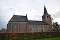
 De Hervormde Kerk te Eethen 2.jpg 6,221 × 5,033; 30.63 MB
-
 De Hervormde Kerk te Eethen.jpg 3,552 × 4,988; 17.04 MB
-
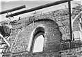
 Detail exterieur naar het noord-oosten - Eethen - 20067855 - RCE.jpg 955 × 1,200; 303 KB
-
 Eethen Hervormde Kerk (PKN) (foto 25-11-2017).1 (f2).jpg 6,000 × 4,000; 6.7 MB
-
 Eethen Hervormde Kerk (PKN) (foto 25-11-2017).2 (f2).jpg 4,000 × 6,000; 6.15 MB
-
 Exterieur naar het zuid-oosten - Eethen - 20067861 - RCE.jpg 1,200 × 961; 252 KB
-
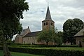
 Exterieur vanuit het noord-oosten - Eethen - 20067853 - RCE.jpg 1,200 × 953; 299 KB
-
 Exterieur vanuit het zuiden naar prentbriefkaart - Eethen - 20067856 - RCE.jpg 1,200 × 743; 218 KB
-
 Hervormde kerk Eethen.jpg 3,008 × 2,000; 1.89 MB
-
 Interieur - Eethen - 20067864 - RCE.jpg 1,200 × 843; 207 KB
-
 Interieur schip naar het westen - Eethen - 20067866 - RCE.jpg 836 × 1,200; 181 KB
-
 Interieur schip van het noordoosten - Eethen - 20067865 - RCE.jpg 1,200 × 841; 215 KB
-
 Inwendig - Eethen - 20067867 - RCE.jpg 843 × 1,200; 243 KB
-
 Noordgevel schip - Eethen - 20067860 - RCE.jpg 1,200 × 836; 245 KB
-
 Overzicht noordoostgevel met kerktoren - Eethen - 20347063 - RCE.jpg 1,197 × 1,200; 395 KB
-
 Overzicht noordoostgevel met kerktoren - Eethen - 20347066 - RCE.jpg 1,200 × 1,199; 343 KB
-
 Overzicht van de zuidgevel - Eethen - 20413612 - RCE.jpg 800 × 1,200; 236 KB
-
 Ruïne van kerkgebouw - Eethen - 20399094 - RCE.jpg 1,200 × 791; 243 KB
-
 Venster noord gevel - Eethen - 20067862 - RCE.jpg 1,200 × 828; 287 KB
-
 Voor - Eethen - 20067869 - RCE.jpg 805 × 1,200; 154 KB
-

-

-
 Zijgevel - Eethen - 20067868 - RCE.jpg 1,200 × 806; 181 KB
-
 Zijgevel - Eethen - 20067870 - RCE.jpg 1,200 × 812; 158 KB
-
 Zuid-gevel - Eethen - 20067854 - RCE.jpg 1,200 × 944; 341 KB


_(foto_25-11-2017).1_(f2).jpg)
_(foto_25-11-2017).2_(f2).jpg)


