Category:Hexenturm (Weinheim)
Jump to navigation
Jump to search
| Object location | | View all coordinates using: OpenStreetMap |
|---|
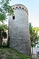
Deutsch: Der Hexenturm in der Grundelbachstraße, Weinheim ist ein Überrest eines im 13. Jh. erbauten Doppelturms.
Media in category "Hexenturm (Weinheim)"
The following 4 files are in this category, out of 4 total.
-
 Weinheim 2011 007.jpg 1,536 × 2,048; 1.21 MB
-
 Weinheim 2011 008.jpg 2,048 × 1,536; 1.09 MB
-
 Weinheim, Hexenturm 20170601 001.jpg 4,003 × 5,996; 14.14 MB
-
 Weinheim, Hexenturm 20170601 002.jpg 4,003 × 5,996; 14.04 MB


