Category:Hof Hauenstein
Jump to navigation
Jump to search
| Object location | | View all coordinates using: OpenStreetMap |
|---|
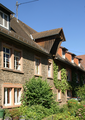
This is the category of the Bavarian Baudenkmal (cultural heritage monument) with the ID D-6-71-138-24 (Wikidata)
|
cultural heritage monument D-6-71-138-24 (0) in Krombach (Unterfranken), Bavaria  | |||||
| Upload media | |||||
| Instance of |
| ||||
|---|---|---|---|---|---|
| Location | Krombach, Aschaffenburg, Lower Franconia, Bavaria, Germany | ||||
| Street address |
| ||||
| Heritage designation | |||||
| Elevation above sea level |
| ||||
 | |||||
Media in category "Hof Hauenstein"
The following 6 files are in this category, out of 6 total.
-
 Hofgut Hauenstein.JPG 2,816 × 2,112; 2.28 MB
-
 Krombach Hof Hauenstein (01).png 2,580 × 1,521; 5.02 MB
-
 Krombach Hof Hauenstein (02).png 2,247 × 1,924; 6.11 MB
-
 Krombach Hof Hauenstein (03).png 1,900 × 2,680; 6.96 MB
-
 Wappen Hof Hauenstein (Spessart) 01.jpg 2,942 × 2,698; 1.24 MB
-
 Wappen Hof Hauenstein (Spessart) 02.jpg 4,935 × 2,823; 2.28 MB
.png)
.png)
.png)
_01.jpg)
_02.jpg)