Category:Hulme End
Jump to navigation
Jump to search
English: Hulme End is a small hamlet in Staffordshire, England. It is located in the Peak District National Park about 10 miles north of Ashbourne. A natural gateway to the Manifold valley, the settlement is located beside the river Manifold where it crosses the road from Hartington (the nearest small town) to Warslow.
human settlement in United Kingdom  | |||||
| Upload media | |||||
| Instance of | |||||
|---|---|---|---|---|---|
| Location |
| ||||
 | |||||
Media in category "Hulme End"
The following 31 files are in this category, out of 31 total.
-
 Back of Ecton Farm - geograph.org.uk - 1453278.jpg 640 × 480; 80 KB
-
 Barracks Farm campsite - geograph.org.uk - 414607.jpg 640 × 480; 123 KB
-
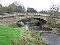 Bridge over River Manifold, Hulme End.jpg 800 × 600; 140 KB
-
 Cowlow Farm, Warslow - geograph.org.uk - 516186.jpg 640 × 422; 93 KB
-
 Descending Ecton Hill - geograph.org.uk - 1417802.jpg 640 × 426; 387 KB
-
 Entrance to Lower Hurst Farm - geograph.org.uk - 326482.jpg 640 × 480; 69 KB
-
 Footpath near Gateham Grange - geograph.org.uk - 198571.jpg 480 × 640; 100 KB
-
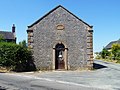 Former Chapel, Hulme End.jpg 4,059 × 3,044; 2.83 MB
-

-
 Milepost 1 mile from Hartington.jpg 480 × 640; 78 KB
-
 Smallholding at East Ecton - geograph.org.uk - 1453293.jpg 640 × 480; 82 KB
-
 Stroll through the hills - geograph.org.uk - 1417855.jpg 640 × 426; 380 KB
-
 The Manifold Valley above Hulme End - geograph.org.uk - 455732.jpg 640 × 427; 115 KB
-

-
 Winter feed for the sheep - geograph.org.uk - 326491.jpg 640 × 480; 142 KB
-
 Wolfscote dale - geograph.org.uk - 7264.jpg 640 × 480; 128 KB
-
 Bridge over the River Dove - geograph.org.uk - 327113.jpg 640 × 428; 129 KB
-
 Bridleway near Alstonefield - geograph.org.uk - 198581.jpg 480 × 640; 102 KB
-
 Bull with cows - geograph.org.uk - 198572.jpg 640 × 480; 83 KB
-
 Buttercup meadow - geograph.org.uk - 456295.jpg 640 × 480; 91 KB
-
 Endon Cottage near Hulme End - geograph.org.uk - 326505.jpg 640 × 479; 138 KB
-
 Farm house in valley below Wetton Hill - geograph.org.uk - 271522.jpg 640 × 427; 102 KB
-
 Footpath, Ecton Hill - geograph.org.uk - 326525.jpg 480 × 640; 145 KB
-
 Gate to access land - geograph.org.uk - 1419075.jpg 425 × 640; 98 KB
-
 Hole End Cottage - geograph.org.uk - 235562.jpg 640 × 480; 147 KB
-
 How Narrowdale - geograph.org.uk - 103298.jpg 640 × 480; 61 KB
-
 Muck spreader at Barracks Farm - geograph.org.uk - 397821.jpg 640 × 480; 124 KB
-
 Narrowdale Hill - geograph.org.uk - 307233.jpg 640 × 426; 138 KB
-
 Paddock House Farm, Back of Ecton - geograph.org.uk - 326528.jpg 640 × 453; 123 KB
-
 Upper Hurst Farm - geograph.org.uk - 326493.jpg 640 × 480; 81 KB
-
 Westside Mill - geograph.org.uk - 326502.jpg 640 × 480; 127 KB


