Category:Ifield
Jump to navigation
Jump to search
English: Ifield is a former village and now a neighbourhood within the town of Crawley in West Sussex, England. Ifield is in the west of the town and is bordered by Langley Green to the north east, West Green to the east across the ring road and Gossops Green and Bewbush to the south across the Arun Valley railway line.
village in United Kingdom  | |||||
| Upload media | |||||
| Instance of |
| ||||
|---|---|---|---|---|---|
| Location | Crawley, West Sussex, South East England, England | ||||
 | |||||
Subcategories
This category has the following 12 subcategories, out of 12 total.
E
- Elim Church Crawley, Ifield (5 F)
G
- Gurjar Hindu Temple, Crawley (10 F)
I
- Friends' Meeting House, Ifield (16 F)
- Ifield Barn Theatre (4 F)
- Ifield railway station (8 F)
- Ifield War Memorial, West Sussex (11 F)
- Ifield Water Mill (17 F)
P
- Plough Inn, Ifield (7 F)
R
- Royal Oak, Ifield (7 F)
Media in category "Ifield"
The following 24 files are in this category, out of 24 total.
-
 Air Training Corps (19th Crawley), Friston Walk, Ifield.JPG 2,200 × 1,600; 939 KB
-

-
 By Prestwood Lane - geograph.org.uk - 1459210.jpg 640 × 444; 56 KB
-
 Charlwood Road - geograph.org.uk - 1502345.jpg 640 × 480; 118 KB
-
 Charlwood Road Ifield Green - geograph.org.uk - 3583335.jpg 3,196 × 2,326; 3.44 MB
-
 Frederick Knott, Masonic Hall (4141704108).jpg 2,592 × 1,944; 1.81 MB
-
 Housing in Crawley - Cottages near St Margaret's Church, Ifield.JPG 2,000 × 1,800; 878 KB
-
 Housing in Crawley - Millfield Court, Ifield.JPG 2,200 × 1,600; 941 KB
-

-
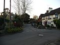
 Ifield Parade - geograph.org.uk - 516426.jpg 640 × 480; 97 KB
-
 Ifield Steam Mill, Mill Lane, Ifield, Crawley.JPG 2,400 × 1,800; 1.31 MB
-
 Ifield Village Green, Rectory Lane, Ifield, Crawley.JPG 640 × 480; 156 KB
-
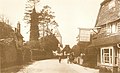 Ifield Village, Crawley, 1905.jpg 939 × 575; 73 KB
-
 Ifield Wood - geograph.org.uk - 3583341.jpg 3,264 × 2,448; 5.22 MB
-
 Manor Green Special Schools - geograph.org.uk - 516432.jpg 640 × 480; 73 KB
-
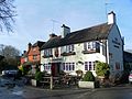 Plough Inn and Cottages in Ifield Village, Crawley.JPG 2,400 × 1,800; 1.14 MB
-
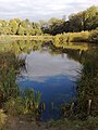 Pond at Ifield, by the mill - geograph.org.uk - 591319.jpg 480 × 640; 101 KB
-
 Pound Cottages - geograph.org.uk - 516464.jpg 480 × 640; 95 KB
-

-
 View of Ifield Village conservation area.JPG 3,456 × 2,592; 3.77 MB
-

-
 Ifield Community College - geograph.org.uk - 22132.jpg 450 × 298; 32 KB
-

-
 Telecom Mast, Ifield, Crawley, West Sussex - geograph.org.uk - 27580.jpg 640 × 449; 117 KB
,_Friston_Walk,_Ifield.JPG)
_to_Carylls_Lea_Junction_(Faygate)._-_geograph.org.uk_-_27322.jpg)


.jpg)


