Category:Imperii Orientalis et Circumjacentium Regionum (early 18th century map) by Guillaume Delisle
Jump to navigation
Jump to search
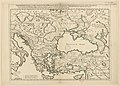
The map depicts the Byzantine Empire around the 10th and 11th century, and was created in the 18th-century.
The date of this map is given by "David Rumsey Historical Map Collection" as: 1715 (?)
The date of this map is given by "Geographicus" as: "probably the 1718 edition"
The date of various versions of this map are given by "Gallica" as: 1726, 1745 and "between 1700 and 1750".
Subcategories
This category has only the following subcategory.
Media in category "Imperii Orientalis et Circumjacentium Regionum (early 18th century map) by Guillaume Delisle"
The following 38 files are in this category, out of 38 total.
-

-
 Banduri and Lisle. Imperii Orientalis et Circumjacentium Regionum.A.jpg 7,731 × 5,787; 8.45 MB
-
 Banduri and Lisle. Imperii Orientalis et Circumjacentium Regionum.jpg 10,710 × 7,075; 12.78 MB
-
-

-

-

-

-
 Banduri, Covens et Mortier and Lisle. Imperii Orientalis et Circumjacentium Regionum.1742.jpg 9,910 × 7,104; 12.41 MB
-

-

-

-

-

-

-
 Banduri and Lisle. Imperii Orientalis et Circumjacentium Regionum.D.jpg 4,530 × 2,382; 2.15 MB
-
 Banduri and Lisle. Imperii Orientalis et Circumjacentium Regionum.E (Bulgaria).jpg 1,894 × 1,114; 407 KB
-
 Banduri and Lisle. Imperii Orientalis et Circumjacentium Regionum.E (Chazaria).jpg 1,948 × 2,004; 779 KB
-
 Banduri and Lisle. Imperii Orientalis et Circumjacentium Regionum.E (Patzinacia).jpg 2,460 × 1,970; 948 KB
-
 Banduri and Lisle. Imperii Orientalis et Circumjacentium Regionum.E (Serbia).jpg 1,244 × 802; 229 KB
-
 Banduri and Lisle. Imperii Orientalis et Circumjacentium Regionum.E (Turcia).jpg 2,756 × 2,053; 1.11 MB
-
 Banduri and Lisle. Imperii Orientalis et Circumjacentium Regionum.E.jpg 5,933 × 3,069; 3.37 MB
-
 Banduri and Lisle. Imperii Orientalis et Circumjacentium Regionum.F (DalmatiÆ Thema).jpg 1,404 × 1,414; 439 KB
-

-
 Banduri and Lisle. Imperii Orientalis et Circumjacentium Regionum.G.jpg 3,765 × 2,759; 2.03 MB
-
 Banduri and Lisle. Imperii Orientalis et Circumjacentium Regionum.H.jpg 6,184 × 298; 372 KB
-
 Banduri and Lisle. Imperii Orientalis et Circumjacentium Regionum.I.jpg 1,828 × 360; 112 KB
-

-

-

-

-

-
 Banduri and Lisle. Imperii Orientalis et Circumjacentium Regionum.B.jpg 4,286 × 2,410; 1.93 MB
-
-
 Banduri and Lisle. Imperii Orientalis et Circumjacentium Regionum.C (Iberia, Lazica).jpg 1,048 × 1,513; 319 KB
-

-
 Banduri and Lisle. Imperii Orientalis et Circumjacentium Regionum.C.jpg 3,078 × 2,923; 1.67 MB
-


_-_Geographicus_-_ImperiiOrientalis-delisle-1715.jpg)
.jpg)

.jpg)
.jpg)
.jpg)
.jpg)
.jpg)

.jpg)
.jpg)
.jpg)
.jpg)
.jpg)

.jpg)
.jpg)

.jpg)

.jpg)
.jpg)
.jpg)

.jpg)
.jpg)
.jpg)

.jpg)
.jpg)
Categories:
- 18th-century maps showing history
- Old maps of the Byzantine Empire
- Maps by Guillaume Delisle showing history
- Anselmo Banduri
- Maps of Byzantine provinces
- 18th-century maps of the Balkans
- 18th-century maps of the Black Sea
- David Rumsey Historical Map Collection
- Maps from Gallica by name
- Latin-language maps showing history
- Covens en Mortier