Category:Information boards in Landkreis Sächsische Schweiz-Osterzgebirge
Jump to navigation
Jump to search
Media in category "Information boards in Landkreis Sächsische Schweiz-Osterzgebirge"
The following 32 files are in this category, out of 32 total.
-
 2020 Dippoldiswalde Polypark Förderung.jpg 2,807 × 2,135; 3.4 MB
-
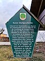 Altendorf-Infotafel-Dorfgeschichte 20240107 131711.jpg 2,992 × 4,000; 3.84 MB
-
 Amselgrund bei Rathen 19.JPG 4,000 × 3,000; 4.82 MB
-
 Aussichtspunkt Alte Teplicer Poststraße 04.jpg 2,962 × 2,038; 1.52 MB
-
 Aussichtspunkt Kalkofen-Rundwanderweg Borna 02.jpg 3,565 × 1,124; 1 MB
-
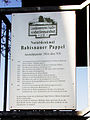 Informationstafel Babisnauer Pappel.JPG 1,536 × 2,048; 702 KB
-
 Babisnauer Pappel 03.jpg 3,456 × 3,840; 1.9 MB
-
 Bogenbrücke mit Geländer Hohnstein 03.jpg 1,816 × 4,032; 2.73 MB
-
 Brunnen Wilmsdorf 20210718.jpg 2,656 × 1,494; 1.68 MB
-
 Burg Tharandt 01.jpg 3,559 × 2,330; 1.47 MB
-
 Diebshöhle Hohnstein 02.jpg 1,816 × 2,666; 1.44 MB
-
 Dippoldiswalder Heide 1612.jpg 2,031 × 1,523; 659 KB
-
 DRK - Kreisverband Sebnitz - Bild 001.jpg 3,150 × 6,164; 9.19 MB
-
 FND Cottaer Spitzberg.jpg 532 × 407; 86 KB
-
 Friedenskapelle Kleinnaundorf (Freital), Infotafel.jpg 3,000 × 4,000; 2.63 MB
-
 Gaustritz 02.jpg 2,945 × 4,312; 2.43 MB
-
 Gaustritz 06.jpg 2,990 × 4,196; 1.93 MB
-
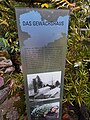 Gewächshaus im Forstbotanischen Garten Tharandt, Infotafel.jpg 3,000 × 4,000; 2.4 MB
-
 Grumbach Geleitstelle-01.jpg 5,239 × 3,929; 6.59 MB
-
 Grumbach Geleitstelle-02.jpg 5,145 × 3,859; 7.94 MB
-
 Grumbach Geleitstelle-03.jpg 3,992 × 5,323; 7.79 MB
-
 Infotafel am Königsplatz im Forstbotanischen Garten.jpg 3,000 × 4,000; 2.42 MB
-
 Labyrinth im Forstbotanischen Garten Tharandt, Infotafel.jpg 3,000 × 4,000; 2.21 MB
-
 Nationalpark Sächsische Schweiz Brand lub 2024-05-04 img18 Thümmelgrotte.jpg 3,024 × 4,032; 5.95 MB
-
 Nordkap Lobendava 2010 (06).jpg 3,072 × 2,304; 2.03 MB
-
 Polish-Saxon Post Milestone in Borna (Bahretal) 03.jpg 2,947 × 2,043; 1.47 MB
-
 Rathewalde, Infotafel Willy Alwin Rotzsch.jpg 3,000 × 4,000; 3.08 MB
-
 Schanzberg Hohnstein.jpg 2,600 × 1,814; 1.15 MB
-
 Schlacht bei Kesselsdorf 1745 - Gedenktafel auf dem Marktplatz.jpg 6,000 × 4,000; 19.93 MB
-
 Sign of Das Nordkap of Czech Republic near Severní, Lobendava, Děčin District.jpg 3,888 × 2,592; 4.43 MB
-
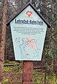
 Zeisiggrund, Infotafel.jpg 3,000 × 4,000; 2.62 MB
-
 Zeisiggrundbrücke, Infotafel.jpg 2,475 × 3,973; 2.08 MB


,_Infotafel.jpg)


.jpg)
_03.jpg)


