Category:Isle of Man
Перайсьці да навігацыі
Перайсьці да пошуку
Краіны Эўропы: Азэрбайджан‡ · Альбанія · Андора · Армэнія‡ · Аўстрыя · Баўгарыя · Беларусь · Босьнія і Герцагавіна · Бэльгія · Ватыкан · Вугоршчына · Вялікабрытанія · Гішпанія‡ · Грузія‡ · Грэцыя · Данія · Ірляндыя · Ісьляндыя · Італія · Казахстан‡ · Кіпр‡ · Латвія · Летува · Ліхтэнштайн · Люксэмбург · Паўночная Македонія · Малдова · Мальта · Манака · Нарвэгія · Нідэрлянды‡ · Нямеччына · Партугалія‡ · Польшча · Расея‡ · Румынія · Сан-Марына · Славаччына · Славенія · Сэрбія · Турэччына‡ · Украіна · Фінляндыя · Францыя‡ · Харватыя · Чарнагорыя · Чэхія · Швайцарыя · Швэцыя · Эстонія
Асаблівы статус: Акратыры і Дэкелія‡ · Фарэрскія астравы · Гернсі · Гібральтар · Джэрзі · Мэн · Шпіцбэрген – Абмежаванае прызнаньне: Абхазія‡ · Гагавузія · Косава · Паўднёвая Асэтыя‡ · Паўночны Кіпр‡ · Прыднястроўе · UN Buffer Zone in Cyprus‡
‡: часткова знаходзяцца ў Эўропе
Асаблівы статус: Акратыры і Дэкелія‡ · Фарэрскія астравы · Гернсі · Гібральтар · Джэрзі · Мэн · Шпіцбэрген – Абмежаванае прызнаньне: Абхазія‡ · Гагавузія · Косава · Паўднёвая Асэтыя‡ · Паўночны Кіпр‡ · Прыднястроўе · UN Buffer Zone in Cyprus‡
‡: часткова знаходзяцца ў Эўропе
Countries of the British Isles: Ірляндыя · Вялікабрытанія
UK constituent countries: Ангельшчына · Паўночная Ірляндыя · Шатляндыя · Ўэйлз
Crown dependencies: Гернсі‡ · Джэрзі‡ · Мэн
Islands: Alderney · Вялікабрытанія · Ірляндыя · Джэрзі‡ · Мэн · Сарк‡
‡: Sometimes considered part of the British Isles
UK constituent countries: Ангельшчына · Паўночная Ірляндыя · Шатляндыя · Ўэйлз
Crown dependencies: Гернсі‡ · Джэрзі‡ · Мэн
Islands: Alderney · Вялікабрытанія · Ірляндыя · Джэрзі‡ · Мэн · Сарк‡
‡: Sometimes considered part of the British Isles
Краіны Вялікай Брытаніі: Ангельшчына · Паўночная Ірляндыя · Ўэйлз · Шатляндыя – Залежнасьці Брытанскай кароны: Гернсі · Джэрзі · Мэн
Брытанскія заморскія тэрыторыі: British Antarctic Territory · Акратыры і Дэкелія · Ангілья · Астравы Піткейрна · Астравы Сьвятой Гэлены · Брытанская тэрыторыя ў Індыйскім акіяне · Брытанскія Віргінскія астравы · Бэрмудзкія астравы · Гібральтар · Кайманавы астравы · Паўднёвая Георгія і Паўднёвыя Сэндвічавыя астравы · Тэркс і Кэйкас · Фолклэндзкія астравы
Брытанскія заморскія тэрыторыі: British Antarctic Territory · Акратыры і Дэкелія · Ангілья · Астравы Піткейрна · Астравы Сьвятой Гэлены · Брытанская тэрыторыя ў Індыйскім акіяне · Брытанскія Віргінскія астравы · Бэрмудзкія астравы · Гібральтар · Кайманавы астравы · Паўднёвая Георгія і Паўднёвыя Сэндвічавыя астравы · Тэркс і Кэйкас · Фолклэндзкія астравы
historic nation and a self-governing British Crown dependency  someja satełitar in agosto    | |||||
| Загрузіць мэдыя | |||||
| Асобны выпадак панятку | |||||
|---|---|---|---|---|---|
| Частка ад |
| ||||
| Цяперашняе месцазнаходжаньне | Ірляндзкае мора | ||||
| Сталіца | |||||
| Заканадаўчы орган | |||||
| Выканаўчая ўлада | |||||
| Афіцыйная мова | |||||
| Гімн | |||||
| Валюта | |||||
| Кіраўнік дзяржавы |
| ||||
| Кіраўнік адміністрацыі |
| ||||
| Дата заснаваньня / стварэньня |
| ||||
| Найвышэйшы пункт | |||||
| Колькасьць насельніцтва |
| ||||
| Плошча |
| ||||
| Дамэн верхняга роўню | |||||
| Ня блытаць з | |||||
| афіцыйны вэб-сайт | |||||
 | |||||
Падкатэгорыі
Гэтая катэгорыя зьмяшчае наступную 21 падкатэгорыю з 21 агулам.
Старонкі ў катэгорыі «Isle of Man»
Гэтая катэгорыя ўтрымлівае толькі адну старонку.
Файлы ў катэгорыі «Isle of Man»
Паказаныя 200 файлаў гэтай катэгорыі з 578.
(папярэдняя старонка) (наступная старонка)-
 'Bollelin' pewter plate designed by Archibald Knox.jpg 4608 × 3456; 3,38 Мб
-
 1966 Morris Minor.jpg 5184 × 3456; 6,48 Мб
-
 1973 Rolls Royce Silver Shadow.jpg 5184 × 3456; 5,93 Мб
-
 1999 Toyota Avensis 01.jpg 3648 × 2736; 3,36 Мб
-
 1999 Toyota Avensis 02.jpg 3648 × 2736; 4,11 Мб
-
 1999 Toyota Avensis 03.jpg 3648 × 2736; 4,47 Мб
-
 1999 Toyota Avensis 04.jpg 5120 × 3840; 6 Мб
-
 1999 Toyota Avensis 05.jpg 3648 × 2736; 4,27 Мб
-
 26th Milestone IMG P000037.jpg 1533 × 1150; 639 кб
-
 29.07.17 Bungalow No.1 (36271748346).jpg 6016 × 4000; 12,83 Мб
-
 29.07.17 Derby Castle "Steve" (35919258180).jpg 5953 × 3958; 12,95 Мб
-
 29.07.17 Derby Castle No.2 (36271809126).jpg 5840 × 3882; 15,76 Мб
-
 29.07.17 Groudle No.21 (36313934445).jpg 5953 × 3629; 13,48 Мб
-
 29.07.17 Snaefell Summit No.2 and No.6 (36313908225).jpg 5725 × 3806; 12,91 Мб
-
 29.07.17 Snaefell Summit No.6 (36313916495).jpg 5180 × 3899; 11,93 Мб
-
 A Fence past its Best Before Date - geograph.org.uk - 5346956.jpg 640 × 424; 81 кб
-
 A guiding light ^^^ - geograph.org.uk - 1252883.jpg 640 × 480; 33 кб
-
 A Little Glen Near Kionlough - geograph.org.uk - 5346845.jpg 640 × 424; 72 кб
-
 A Mini Waterfall Below Ballasalla Farm - geograph.org.uk - 6122437.jpg 678 × 1024; 177 кб
-
 A Quarter wall, on Clay Head - geograph.org.uk - 1814364.jpg 600 × 800; 236 кб
-
 A Small Dark Drop (14523385887).jpg 4928 × 3264; 3,84 Мб
-
 A small prominence in the coastline - geograph.org.uk - 1815268.jpg 800 × 600; 217 кб
-
 A stiff breeze today - geograph.org.uk - 3850095.jpg 640 × 480; 56 кб
-
 A Stream Across The Beach - geograph.org.uk - 6122443.jpg 1024 × 678; 148 кб
-
 A Stream Near Jurby Head - geograph.org.uk - 6122480.jpg 678 × 1024; 205 кб
-
 A Stream Reaches the Sea - geograph.org.uk - 6122429.jpg 1024 × 678; 172 кб
-
 A trifle inclement n'est pas^ - geograph.org.uk - 2597562.jpg 3200 × 1800; 1,42 Мб
-
 A view across the washing floors of the Great Snaefell Mine.jpg 320 × 240; 37 кб
-
 Abandoned Boiler along Tram Line - panoramio.jpg 3648 × 2736; 2,91 Мб
-
 Abandoned Structure at Cronk y Cliwe - geograph.org.uk - 6121765.jpg 1024 × 678; 151 кб
-
 An abstract of the laws, customs, and ordinances of the Isle of Man, vol. 1. (microform) (IA abstractoflawscu00gelliala).pdf 781 × 1281, 282 старонкі; 14,92 Мб
-
 California Digital Library (IA accountofpastpre00woodrich).pdf 777 × 1304, 390 старонак; 28,29 Мб
-
 Across Orrisdale Beach - geograph.org.uk - 6122107.jpg 1024 × 678; 183 кб
-
 Advert for St David.png 394 × 724; 63 кб
-
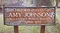 Amy Johnson's tree.jpg 3264 × 1836; 4,82 Мб
-
 An 'easel' clock style 0608 designed by Knox.jpg 3456 × 4608; 3,32 Мб
-
 An October evening at Rue Point - geograph.org.uk - 5569979.jpg 1600 × 1202; 421 кб
-
 Approaching The Cronk - geograph.org.uk - 6122256.jpg 1024 × 678; 168 кб
-
 Arch to former tramway - geograph.org.uk - 3620657.jpg 640 × 480; 98 кб
-
 Baie Doo and Ooigyn Dhoo - geograph.org.uk - 1825087.jpg 800 × 600; 183 кб
-
 Balladoole Isle of Man.jpg 1600 × 1200; 410 кб
-
 Ballaugh Shore - geograph.org.uk - 3939049.jpg 640 × 480; 69 кб
-
 Bay below Keristal - geograph.org.uk - 3153098.jpg 2592 × 1936; 2,02 Мб
-
 Bay ny Carrickey (or Gansey Bay) - geograph.org.uk - 5550994.jpg 2592 × 1944; 1,03 Мб
-
 Bay Ny Carrickey - geograph.org.uk - 2384244.jpg 640 × 480; 179 кб
-
 Bay ny Carrickey - the eastern shoreline - geograph.org.uk - 4874601.jpg 5184 × 3888; 5,36 Мб
-
 Bay Stacka - geograph.org.uk - 4824527.jpg 640 × 480; 97 кб
-

-

-

-

-

-
 Beach and Ramsey Bay - geograph.org.uk - 3620008.jpg 1920 × 1276; 583 кб
-
 Beach at Kirk Michael - geograph.org.uk - 6290927.jpg 1024 × 683; 185 кб
-
 Beach at Orisdale Head - geograph.org.uk - 6122068.jpg 1024 × 678; 147 кб
-
 Beach at Port St Mary - geograph.org.uk - 1847295.jpg 800 × 600; 127 кб
-
 Beach below Orrisdale Head - geograph.org.uk - 2145487.jpg 1024 × 768; 105 кб
-
 Beach by Cronk y Scottey - geograph.org.uk - 4821987.jpg 640 × 480; 65 кб
-
 Beach near Kirk Michael - geograph.org.uk - 4445849.jpg 1024 × 678; 155 кб
-
 Bee Gees Birthplace.jpg 3648 × 2736; 3,22 Мб
-
 Boat approaching Cow Harbour - geograph.org.uk - 4379500.jpg 640 × 480; 51 кб
-
 Boat stranded in Douglas Harbour - panoramio.jpg 4320 × 3240; 4,51 Мб
-
 Boat to Isle of Man. Irish Sea (050230) (9453726762).jpg 1604 × 2330; 1,24 Мб
-
 Bond Bug & Classic Cars.jpg 5184 × 3456; 6,55 Мб
-
 Boulder Eroding Out Of The Cliff - geograph.org.uk - 5346925.jpg 424 × 640; 96 кб
-
 Boulder ^ Beach - geograph.org.uk - 5346879.jpg 424 × 640; 63 кб
-
 Boulders on The Beach - geograph.org.uk - 5346903.jpg 424 × 640; 86 кб
-
 Braddan 138.jpg 1136 × 885; 350 кб
-
 Braddan Bridge pass out.JPG 486 × 342; 26 кб
-
 Braggan Point - geograph.org.uk - 1819647.jpg 800 × 600; 142 кб
-
 Breaking waves on the shoreline at Blue Point - geograph.org.uk - 6301677.jpg 1600 × 1200; 625 кб
-
 Bridge on the old mine road - panoramio.jpg 4320 × 3240; 4,27 Мб
-
 Burroo Ned and Spanish Head - geograph.org.uk - 5696688.jpg 1620 × 1080; 498 кб
-
 Calf Sound in the Mist - panoramio.jpg 4000 × 3000; 3,48 Мб
-
 Cammag Sticks.jpg 3448 × 4592; 8,83 Мб
-
 Capt. Kitto's Grave.jpg 480 × 640; 186 кб
-
 Castle from Fenella Beach, Peel - panoramio.jpg 3008 × 2000; 758 кб
-
 Castle Mona.jpg 960 × 705; 116 кб
-
 Castle street in peel.jpg 1536 × 2048; 1,02 Мб
-
 Citroen 2CV in red.jpg 5184 × 3456; 5,74 Мб
-
 Clay Head - geograph.org.uk - 1814342.jpg 800 × 600; 152 кб
-
 Cliff Fall Below Cronk ny Arry Lhaa - geograph.org.uk - 6122494.jpg 1024 × 678; 169 кб
-
 Cliff just south of The Clett - geograph.org.uk - 1819616.jpg 800 × 600; 184 кб
-
 Cliff scenery near Ballavarane - geograph.org.uk - 1819603.jpg 800 × 600; 157 кб
-
 Cliffs and beach looking towards Shellag Point - geograph.org.uk - 3620012.jpg 1920 × 1276; 494 кб
-
 Cliffs and Cove North of Traie Cronkan - geograph.org.uk - 6123134.jpg 1024 × 678; 166 кб
-
 Cliffs at Port Soderick - geograph.org.uk - 3153119.jpg 2592 × 1936; 2,01 Мб
-
 Cliffs from Marine Drive - geograph.org.uk - 3153141.jpg 2592 × 1936; 2,43 Мб
-
 Cliffs just north of The Clett rock - geograph.org.uk - 1814379.jpg 800 × 600; 196 кб
-
 Cliffs near Shellag Point - geograph.org.uk - 2145539.jpg 1024 × 768; 173 кб
-
 Cmglee Douglas Isle of Man aerial view.jpg 3200 × 4800; 2 Мб
-
 Coast at Glen Mooar - geograph.org.uk - 4445826.jpg 1024 × 678; 219 кб
-
 Coastal cliffs north of Traie ny Unaig - geograph.org.uk - 1815786.jpg 800 × 600; 170 кб
-
 Coastal Path at Derby Haven - geograph.org.uk - 5726886.jpg 1600 × 1065; 621 кб
-
 Coastal path at Ronaldsway airport - geograph.org.uk - 5726882.jpg 1600 × 1065; 584 кб
-
 Coastal scenery near Ballakilley Farm - geograph.org.uk - 1819613.jpg 800 × 600; 177 кб
-
 Coastline near the Keristal - geograph.org.uk - 3636128.jpg 640 × 480; 85 кб
-
-
 Coastline view from near Keristal - geograph.org.uk - 5779437.jpg 427 × 640; 85 кб
-
 Collapsing cliffs near Cronk ny Arrey Laa - geograph.org.uk - 3620019.jpg 1600 × 1657; 774 кб
-
 Concrete Eroded From the Cliff - geograph.org.uk - 6122208.jpg 1024 × 678; 146 кб
-
 Concrete On The Beach - geograph.org.uk - 6122463.jpg 1024 × 678; 218 кб
-
 Concrete on the Beach Below Jurby Head - geograph.org.uk - 6122451.jpg 1024 × 678; 167 кб
-
 Cor Stack - geograph.org.uk - 1822252.jpg 800 × 600; 193 кб
-
 Cor Stack - geograph.org.uk - 1822268.jpg 800 × 600; 155 кб
-
 Corrin's Tower.jpg 1023 × 683; 173 кб
-
 Cronk y Scottey Beach - geograph.org.uk - 6121724.jpg 1024 × 678; 157 кб
-
 Cronk-y-voddy, bus shelter (geograph 4617178).jpg 1024 × 764; 176 кб
-
 Cronkbreck, dunes - geograph.org.uk - 4619505.jpg 1024 × 768; 226 кб
-
 Crosh Cuirn.jpg 4478 × 3362; 5,23 Мб
-
 Crumbling clay at Shellag Point - geograph.org.uk - 3617160.jpg 1920 × 1278; 489 кб
-
 Departing Douglas - panoramio.jpg 4320 × 3240; 3,47 Мб
-
 Derby Fort.jpg 570 × 427; 76 кб
-
 Derbyhaven Bay - panoramio.jpg 2048 × 1360; 1,33 Мб
-
 Derbyhaven bay, Isle of Man - geograph.org.uk - 1977099.jpg 1024 × 851; 98 кб
-
 Dhoon Bay - geograph.org.uk - 1832543.jpg 800 × 600; 138 кб
-
 Dhoon Beach - geograph.org.uk - 4905744.jpg 640 × 424; 67 кб
-
 Dismembered Crab - geograph.org.uk - 6121732.jpg 1024 × 678; 233 кб
-
 Douglas Transmission station.jpg 133 × 100; 3 кб
-
 Douglas, harbor with steamers, Isle of Man-LCCN2002697025.tif 3711 × 2758; 29,29 Мб
-
 Down the Hillside - panoramio.jpg 3648 × 2736; 2,55 Мб
-
 Drift Wood and The Ayres Beach - geograph.org.uk - 6121496.jpg 678 × 1024; 201 кб
-

-
 Dry Stone Fences north of Dhoon Glen - panoramio.jpg 3648 × 2736; 2 Мб
-
 Dunes and Beach at The Cronk - geograph.org.uk - 6122354.jpg 1024 × 678; 193 кб
-
 Dusk approaching on the shoreline - geograph.org.uk - 6301615.jpg 1600 × 1200; 624 кб
-
 Dusk over Port St Mary viewed from Strandhall Beach - geograph.org.uk - 2742969.jpg 3296 × 2472; 1,29 Мб
-
 Electric Tram Car - panoramio.jpg 3240 × 4320; 3,13 Мб
-
 Electric Tram Stop at Ballaglass - geograph.org.uk - 475154.jpg 640 × 480; 131 кб
-
 End of Glion Cam - geograph.org.uk - 5741790.jpg 424 × 640; 72 кб
-
 Eroded rocks - geograph.org.uk - 3620013.jpg 1920 × 1276; 815 кб
-
 Eroding Cliff Near The Cronk - geograph.org.uk - 6122302.jpg 1024 × 678; 156 кб
-
 Eroding Cliffs at Jurby Head - geograph.org.uk - 6122468.jpg 1024 × 678; 231 кб
-
 Eroding Foundations on The Cliff - geograph.org.uk - 6122219.jpg 678 × 1024; 155 кб
-
 Evening at the Sloc - looking south - panoramio.jpg 4000 × 3000; 3,12 Мб
-
 Fairy Bridge Isle Of Man.jpeg 3264 × 2448; 5,13 Мб
-
 Fields near the railway - geograph.org.uk - 3136442.jpg 3648 × 2736; 1,86 Мб
-

-

-

-
 Fitislaubsänger Isle of Man.jpg 566 × 848; 529 кб
-
 Fleshwick Bay - geograph.org.uk - 2557574.jpg 1280 × 786; 423 кб
-
 Fleshwick Bay - geograph.org.uk - 2592647.jpg 3296 × 2472; 1,98 Мб
-
 Fleshwick Bay - geograph.org.uk - 2592649.jpg 3296 × 2472; 2 Мб
-
 Fleshwick Bay - geograph.org.uk - 3414270.jpg 2560 × 1920; 3,21 Мб
-
 Fleshwick Bay - geograph.org.uk - 5458142.jpg 800 × 549; 132 кб
-
 Fleshwick Bay - geograph.org.uk - 6301716.jpg 1600 × 1200; 513 кб
-
 Flytipping, Isle of Man.jpg 640 × 480; 76 кб
-
 Fog horn at Point of Ayre. Isle of Man. - geograph.org.uk - 4340779.jpg 3648 × 2736; 1,44 Мб
-
 Footbridge and picnic at Glen Maye - geograph.org.uk - 3571727.jpg 1200 × 1239; 657 кб
-
 Footprints in The Sand - geograph.org.uk - 6121803.jpg 678 × 1024; 187 кб
-
 Ford Focus illa de Man.jpg 1800 × 1151; 1,42 Мб
-
 Foreshore, Langness - geograph.org.uk - 4677427.jpg 4608 × 3456; 2,73 Мб
-
 Gansey Beach - geograph.org.uk - 2384736.jpg 640 × 480; 194 кб
-
 Gansey Beach - geograph.org.uk - 2384806.jpg 640 × 480; 214 кб
-
 Gansey Beach - geograph.org.uk - 2384807.jpg 640 × 480; 216 кб
-
 Gansey, Port St Mary - geograph.org.uk - 1849259.jpg 800 × 600; 147 кб
-
 Gian Wooar - geograph.org.uk - 1832603.jpg 800 × 600; 178 кб
-
 Glen Helen, Isle of Man. 781 (NBY 420661).jpg 825 × 521; 72 кб
-
 Glen Maye Beach at low tide - geograph.org.uk - 3571725.jpg 720 × 1000; 255 кб
-
-
 Gob ny Calla - geograph.org.uk - 1815350.jpg 800 × 600; 136 кб
-
 Gob ny Garvain - geograph.org.uk - 1815825.jpg 800 × 600; 135 кб
-
 Gob ny Garvain - geograph.org.uk - 1815862.jpg 800 × 600; 149 кб
-
 Gob ny How - geograph.org.uk - 1815309.jpg 800 × 600; 207 кб
-
 Gob ny Portmooar - geograph.org.uk - 3165847.jpg 2592 × 1936; 1,88 Мб
-
 Gob ny Rona - geograph.org.uk - 1832770.jpg 800 × 600; 146 кб
-
 Gob ny Rona - geograph.org.uk - 1832775.jpg 800 × 600; 142 кб
-
 Gob ny Skey - geograph.org.uk - 1822311.jpg 800 × 600; 158 кб
-
 Gob ny Stroma - geograph.org.uk - 1822647.jpg 800 × 600; 169 кб
-
 Grave of Henry Bloom Nolbe.jpg 480 × 640; 113 кб
-
 Great Britain private parcel service stamps - 4.jpg 2165 × 1269; 345 кб
-
 Great Snaefell Mine (1).jpg 320 × 240; 27 кб
-
 Groudle Glen and Hotel, Isle of Man-LCCN2002697032.tif 2748 × 3722; 29,27 Мб
-
 Groudle Glen, the mill, Isle of Man-LCCN2002697033.tif 2747 × 3660; 28,77 Мб
-
 Guardian of The Cronk Brook - geograph.org.uk - 6122348.jpg 1024 × 678; 153 кб
-
 High Tide at Cronk y Scottey - geograph.org.uk - 6121694.jpg 1024 × 678; 159 кб
-
 Housing development in Groudle Glen - geograph.org.uk - 1825052.jpg 800 × 600; 122 кб
-
 Irree ny Greiney.jpg 4592 × 3240; 3,19 Мб
-
 Isle Of Man (181106699).jpeg 2048 × 1546; 626 кб
-
 Isle Of Man (181106701).jpeg 2048 × 1538; 344 кб
-
 Isle Of Man (181106703).jpeg 2048 × 1544; 856 кб
-
 Isle Of Man (181106727).jpeg 2048 × 1460; 665 кб
-
 Isle Of Man (181106731).jpeg 2048 × 1536; 462 кб
-
 Isle Of Man (181106733).jpeg 2048 × 1536; 664 кб
-
 Isle Of Man (181106737).jpeg 2048 × 1536; 664 кб
-
 Isle Of Man (181106739).jpeg 1932 × 1452; 436 кб
-
 Isle Of Man (181106741).jpeg 2048 × 1536; 1,12 Мб
-
 Isle Of Man (181106745).jpeg 2048 × 1536; 1,34 Мб
-
 Isle Of Man (181106763).jpeg 2048 × 1536; 1,56 Мб
-
 Isle Of Man (181106765).jpeg 2048 × 1536; 1,54 Мб
-
 Isle Of Man (181106769).jpeg 2048 × 1532; 1003 кб
-
 Isle Of Man (181106771).jpeg 2048 × 1536; 1,1 Мб
-
 Isle Of Man (181106773).jpeg 2048 × 1524; 1012 кб
-
 Isle Of Man (181106781).jpeg 2048 × 1536; 1,04 Мб
-
 Isle Of Man (181106783).jpeg 2048 × 1536; 903 кб
-
 Isle Of Man (181106785).jpeg 1600 × 1200; 201 кб
-
 Isle Of Man (181106789).jpeg 2048 × 1524; 1,17 Мб
-
 Isle Of Man (181106859).jpeg 2048 × 1535; 957 кб
-
 Isle Of Man (181106877).jpeg 2048 × 1538; 878 кб


.jpg)
.jpg)
.jpg)
.jpg)
.jpg)
.jpg)


.jpg)


_-_geograph.org.uk_-_5550994.jpg)


_(14)_-_geograph.org.uk_-_2117066.jpg)
_(15)_-_geograph.org.uk_-_2117070.jpg)
_(19)_-_geograph.org.uk_-_2117096.jpg)
_(20)_-_geograph.org.uk_-_2117098.jpg)
_(21)_-_geograph.org.uk_-_2117106.jpg)


_(9453726762).jpg)


.jpg)


.jpg)


.jpg)


.jpeg)
.jpeg)
.jpeg)
.jpeg)
.jpeg)
.jpeg)
.jpeg)
.jpeg)
.jpeg)
.jpeg)
.jpeg)
.jpeg)
.jpeg)
.jpeg)
.jpeg)
.jpeg)
.jpeg)
.jpeg)
.jpeg)
.jpeg)
.jpeg)